Property Record
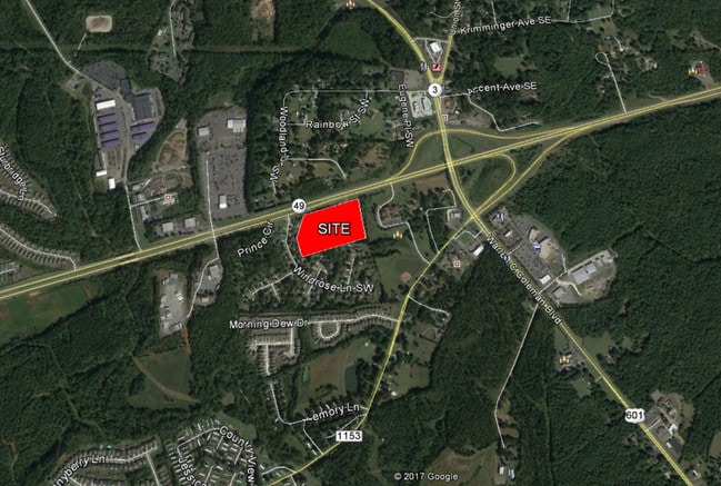
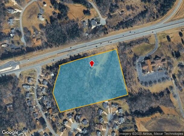
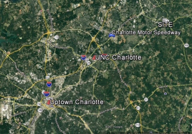
Highway 49, Concord, NC 28025
This Property Is For Sale
NEARBY LISTINGS FOR SALE OR LEASE
Property Detail
Highway 49
Charlotte-Concord-Gastonia, NC-SC
Hwy 60149
5539-63-1768-0000
SOUTH SIDE HWY 49 ADJ WINDROSE
Commercialnec
Cabarrus
X
North Carolina
3710553900K
9.78 AC
2025
Cabarrus County
2025
Charlotte
042202
DEMOGRAPHICS near Highway 49
1 Mile
3 Mile
5 Mile
2024 Total Population
6,013
37,973
72,758
2029 Population
6,724
42,876
82,047
Pop Growth 2024-2029
+ 11.82%
+ 12.91%
+ 12.77%
Average Age
35
37
38
2024 Total Households
1,993
13,188
26,080
HH Growth 2024-2029
+ 10.39%
+ 11.51%
+ 11.35%
Median Household Inc
$79,066
$72,574
$71,173
Avg Household Size
2.90
2.70
2.70
2024 Avg HH Vehicles
2.00
2.00
2.00
Median Home Value
$249,345
$230,882
$243,883
Median Year Built
1999
1991
1990
Nearby Places
Map Layers
Map Styles
 Street
 Aerial
- Restaurants
- Banks
- Shops
- Fitness
- Groceries
PUBLIC TRANSPORTATION
AIRPORT
Concord-Padgett Regional
DRIVE
WALK
Distance
Concord-Padgett Regional
25 min
14.6 mi
Charlotte/Douglas International
DRIVE
WALK
Distance
Charlotte/Douglas International
46 min
30.0 mi
Freight Ports
Port of Wilmington
DRIVE
WALK
Distance
Port of Wilmington
246 min
192.4 mi
Nearby Properties
Address
Land Use
TOTAL SIZE
Lot Size
Zoning
Address
Land Use
TOTAL SIZE
Lot Size
Zoning
162,854 SF
2.11 AC
CC
Address
Land Use
TOTAL SIZE
Lot Size
Zoning
103,849 SF
3.03 AC
CC
Address
Land Use
TOTAL SIZE
Lot Size
Zoning
32,872 SF
0.90 AC
CC
Address
Land Use
TOTAL SIZE
Lot Size
Zoning
122,102 SF
4.69 AC
CC
Address
Land Use
TOTAL SIZE
Lot Size
Zoning
161,202 SF
2.68 AC
CC
Address
Land Use
TOTAL SIZE
Lot Size
Zoning
15,215 SF
30.18 AC
RM-2
Address
Land Use
TOTAL SIZE
Lot Size
Zoning
6,539 SF
173.17 AC
LI
Address
Land Use
TOTAL SIZE
Lot Size
Zoning
19,673 SF
26.67 AC
RC
Address
Land Use
TOTAL SIZE
Lot Size
Zoning
199,363 SF
53.36 AC
I-1
Address
Land Use
TOTAL SIZE
Lot Size
Zoning
94,924 SF
0.39 AC
CC
Address
Land Use
TOTAL SIZE
Lot Size
Zoning
160,412 SF
39.97 AC
O-I
Address
Land Use
TOTAL SIZE
Lot Size
Zoning
126,483 SF
28 AC
OI
Address
Land Use
TOTAL SIZE
Lot Size
Zoning
30,170 SF
0.80 AC
CC
Address
Land Use
TOTAL SIZE
Lot Size
Zoning
7,000 SF
72.56 AC
I-2
Address
Land Use
TOTAL SIZE
Lot Size
Zoning
8,640 SF
15.51 AC
RC
Address
Land Use
TOTAL SIZE
Lot Size
Zoning
126,214 SF
93.87 AC
O-I
Address
Land Use
TOTAL SIZE
Lot Size
Zoning
7,584 SF
12.63 AC
RC
Address
Land Use
TOTAL SIZE
Lot Size
Zoning
170,832 SF
1.27 AC
CC
Address
Land Use
TOTAL SIZE
Lot Size
Zoning
29,256 SF
0.17 AC
CC
Address
Land Use
TOTAL SIZE
Lot Size
Zoning
60,343 SF
14.04 AC
I-1
Address
Land Use
TOTAL SIZE
Lot Size
Zoning
61,196 SF
16.60 AC
I-2
Address
Land Use
TOTAL SIZE
Lot Size
Zoning
17,286 SF
48.94 AC
O-I
Address
Land Use
TOTAL SIZE
Lot Size
Zoning
21,152 SF
6.03 AC
MDR
Address
Land Use
TOTAL SIZE
Lot Size
Zoning
29,883 SF
0.36 AC
CC
Address
Land Use
TOTAL SIZE
Lot Size
Zoning
18,325 SF
20.73 AC
O-I
Address
Land Use
TOTAL SIZE
Lot Size
Zoning
35,313 SF
36.05 AC
C-2
Address
Land Use
TOTAL SIZE
Lot Size
Zoning
2,056 SF
7.23 AC
RC
Address
Land Use
TOTAL SIZE
Lot Size
Zoning
2,154 SF
12.57 AC
RC
Address
Land Use
TOTAL SIZE
Lot Size
Zoning
11,341 SF
7.37 AC
RC
Address
Land Use
TOTAL SIZE
Lot Size
Zoning
34,085 SF
4.26 AC
C-2
The World's #1 Commercial Real Estate Marketplace
Connect with us
© 2026 CoStar Group
The information above has been obtained from sources believed reliable. While we do not doubt its accuracy we have not verified it and make no guarantee, warranty or representation about it. It is your responsibility to independently confirm its accuracy and completeness. Any projections, opinions, assumptions, or estimates used are for example only and do not represent the current or future performance of the property. The value of this transaction to you depends on tax and other factors which should be evaluated by your tax, financial, and legal advisors. You and your advisors should conduct a careful, independent investigation of the property to determine to your satisfaction the suitability of the property for your needs.