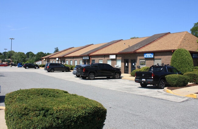
Property Record
0 S Sproul Rd, Broomall, PA 19008


Current Lease Availabilities
NEARBY LISTINGS FOR SALE OR LEASE
Property Detail
0 S Sproul Rd
25-00-04572-01
2-1 STY BLDGS 1.58 ACRES+- (DEBOTTON)
Officebuilding
Delaware
X
Pennsylvania
42045C0103F
1.54 AC
2024
Delaware County
2025
Philadelphia
408102
Philadelphia-Camden-Wilmington, PA-NJ-DE-MD
18,816 SF
DEMOGRAPHICS near 0 S Sproul Rd
1 Mile
3 Mile
5 Mile
2024 Total Population
6,993
102,768
319,225
2029 Population
6,885
101,807
316,437
Pop Growth 2024-2029
(1.54%)
(0.94%)
(0.87%)
Average Age
44
42
40
2024 Total Households
2,616
38,885
121,014
HH Growth 2024-2029
(1.57%)
(0.86%)
(0.88%)
Median Household Inc
$102,561
$108,407
$91,997
Avg Household Size
2.60
2.60
2.50
2024 Avg HH Vehicles
2.00
2.00
2.00
Median Home Value
$388,711
$368,644
$334,798
Median Year Built
1957
1955
1954
Nearby Places
Map Layers
Map Styles
 Street
 Aerial
- Restaurants
- Banks
- Shops
- Fitness
- Groceries
PUBLIC TRANSPORTATION
COMMUTER RAIL
Morton (R3 - Southeastern Pennsylvania Transportation Authority Regional Rail (SEPTA Regional Rail))
DRIVE
WALK
Distance
Morton (R3 - Southeastern Pennsylvania Transportation Authority Regional Rail (SEPTA Regional Rail))
10 min
4.4 mi
Secane (R3 - Southeastern Pennsylvania Transportation Authority Regional Rail (SEPTA Regional Rail))
DRIVE
WALK
Distance
Secane (R3 - Southeastern Pennsylvania Transportation Authority Regional Rail (SEPTA Regional Rail))
11 min
5.1 mi
AIRPORT
Philadelphia International
DRIVE
WALK
Distance
Philadelphia International
24 min
10.9 mi
Freight Ports
South Jersey Port
DRIVE
WALK
Distance
South Jersey Port
35 min
16.2 mi
Nearby Properties
Address
Land Use
TOTAL SIZE
Lot Size
Zoning
Address
Land Use
TOTAL SIZE
Lot Size
Zoning
45,294 SF
83.20 AC
Address
Land Use
TOTAL SIZE
Lot Size
Zoning
59,126 SF
84.57 AC
Address
Land Use
TOTAL SIZE
Lot Size
Zoning
60,768 SF
16.17 AC
Address
Land Use
TOTAL SIZE
Lot Size
Zoning
15,660 SF
56.60 AC
Address
Land Use
TOTAL SIZE
Lot Size
Zoning
48,739 SF
30 AC
Address
Land Use
TOTAL SIZE
Lot Size
Zoning
308,248 SF
52 AC
Address
Land Use
TOTAL SIZE
Lot Size
Zoning
90,784 SF
26.26 AC
Address
Land Use
TOTAL SIZE
Lot Size
Zoning
345,135 SF
37 AC
Address
Land Use
TOTAL SIZE
Lot Size
Zoning
264,399 SF
122.05 AC
Address
Land Use
TOTAL SIZE
Lot Size
Zoning
82,153 SF
13.97 AC
Address
Land Use
TOTAL SIZE
Lot Size
Zoning
702,532 SF
11 AC
Address
Land Use
TOTAL SIZE
Lot Size
Zoning
20,880 SF
27.20 AC
Address
Land Use
TOTAL SIZE
Lot Size
Zoning
30,204 SF
13.75 AC
Address
Land Use
TOTAL SIZE
Lot Size
Zoning
114,058 SF
3.20 AC
Address
Land Use
TOTAL SIZE
Lot Size
Zoning
261,618 SF
30.57 AC
Address
Land Use
TOTAL SIZE
Lot Size
Zoning
13,932 SF
9 AC
Address
Land Use
TOTAL SIZE
Lot Size
Zoning
93,068 SF
12.47 AC
Address
Land Use
TOTAL SIZE
Lot Size
Zoning
229,612 SF
6.05 AC
Address
Land Use
TOTAL SIZE
Lot Size
Zoning
76,600 SF
16.90 AC
Address
Land Use
TOTAL SIZE
Lot Size
Zoning
331,021 SF
35.19 AC
Address
Land Use
TOTAL SIZE
Lot Size
Zoning
69,420 SF
17.12 AC
Address
Land Use
TOTAL SIZE
Lot Size
Zoning
282,520 SF
24.44 AC
Address
Land Use
TOTAL SIZE
Lot Size
Zoning
26,999 SF
21 AC
Address
Land Use
TOTAL SIZE
Lot Size
Zoning
86,052 SF
7.63 AC
Address
Land Use
TOTAL SIZE
Lot Size
Zoning
38,220 SF
22.05 AC
Address
Land Use
TOTAL SIZE
Lot Size
Zoning
72,564 SF
24.44 AC
Address
Land Use
TOTAL SIZE
Lot Size
Zoning
60,588 SF
9.43 AC
Address
Land Use
TOTAL SIZE
Lot Size
Zoning
140,426 SF
10.46 AC
Address
Land Use
TOTAL SIZE
Lot Size
Zoning
100,242 SF
5 AC
Address
Land Use
TOTAL SIZE
Lot Size
Zoning
90,368 SF
124 AC
The World's #1 Commercial Real Estate Marketplace
Connect with us
© 2026 CoStar Group
The information above has been obtained from sources believed reliable. While we do not doubt its accuracy we have not verified it and make no guarantee, warranty or representation about it. It is your responsibility to independently confirm its accuracy and completeness. Any projections, opinions, assumptions, or estimates used are for example only and do not represent the current or future performance of the property. The value of this transaction to you depends on tax and other factors which should be evaluated by your tax, financial, and legal advisors. You and your advisors should conduct a careful, independent investigation of the property to determine to your satisfaction the suitability of the property for your needs.