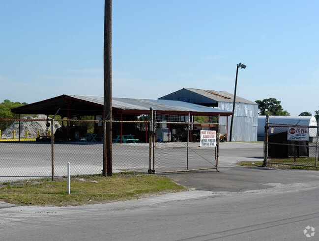
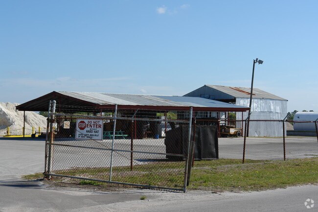
Property Record
Saluda Rd, Lakeland, FL 33801

NEARBY LISTINGS FOR SALE OR LEASE
Property Detail
Saluda Rd
Lakeland-Winter Haven, FL
Howenoca Hills Subdivision
24-28-21-239500-001150
HOWENOCA HILLS SUB PB 9 PG 36 IN SECS 21 22 28 T28 R24 BLK 1 LOTS 15 THRU 25 & THAT PT OF S1/2 OF SE1/4 OF NW1/4 OF SEC 22 ADJ TO LOT 25 DESC AS FOLL: BEGIN AT NE COR OF LOT 25 S89-55-25E ALG N BNDRY OF S1/2 OF SE1/4 OF NW1/4 82.74 FT S52-01- 49W 105
Commercialnec
Polk
AE
Florida
12105C0320G
15-25
2024
2.06 AC
2025
Polk County
011731
Tampa/St Petersburg
DEMOGRAPHICS near Saluda Rd
1 Mile
3 Mile
5 Mile
2024 Total Population
8,652
45,867
118,914
2029 Population
10,300
54,318
141,699
Pop Growth 2024-2029
+ 19.05%
+ 18.43%
+ 19.16%
Average Age
34
37
40
2024 Total Households
2,811
16,500
46,350
HH Growth 2024-2029
+ 19.10%
+ 19.28%
+ 19.50%
Median Household Inc
$40,211
$44,973
$50,640
Avg Household Size
2.50
2.40
2.30
2024 Avg HH Vehicles
2.00
2.00
2.00
Median Home Value
$125,735
$145,964
$165,328
Median Year Built
1976
1974
1978
Nearby Places
Map Layers
Map Styles
 Street
 Aerial
- Restaurants
- Banks
- Shops
- Fitness
- Groceries
PUBLIC TRANSPORTATION
COMMUTER RAIL
Lakeland (Silver Star - Amtrak)
DRIVE
WALK
Distance
Lakeland (Silver Star - Amtrak)
7 min
3.7 mi
Freight Ports
Port of Tampa Bay
DRIVE
WALK
Distance
Port of Tampa Bay
53 min
38.1 mi
Nearby Properties
Address
Land Use
TOTAL SIZE
Lot Size
Zoning
Address
Land Use
TOTAL SIZE
Lot Size
Zoning
414,112 SF
13.60 AC
MF22
Address
Land Use
TOTAL SIZE
Lot Size
Zoning
417,661 SF
39.48 AC
Address
Land Use
TOTAL SIZE
Lot Size
Zoning
24,871 SF
54.24 AC
RB1
Address
Land Use
TOTAL SIZE
Lot Size
Zoning
394,631 SF
32.27 AC
XX
Address
Land Use
TOTAL SIZE
Lot Size
Zoning
282,596 SF
27.51 AC
RA3
Address
Land Use
TOTAL SIZE
Lot Size
Zoning
132,716 SF
20.62 AC
Address
Land Use
TOTAL SIZE
Lot Size
Zoning
155,735 SF
24.24 AC
XX
Address
Land Use
TOTAL SIZE
Lot Size
Zoning
103,446 SF
2.12 AC
RB1
Address
Land Use
TOTAL SIZE
Lot Size
Zoning
135,189 SF
2.57 AC
RB1
Address
Land Use
TOTAL SIZE
Lot Size
Zoning
96,412 SF
11.03 AC
I1
Address
Land Use
TOTAL SIZE
Lot Size
Zoning
286,120 SF
2.49 AC
C6
Address
Land Use
TOTAL SIZE
Lot Size
Zoning
175,230 SF
7.23 AC
MF22
Address
Land Use
TOTAL SIZE
Lot Size
Zoning
109,883 SF
12.40 AC
C4
Address
Land Use
TOTAL SIZE
Lot Size
Zoning
130,375 SF
14.51 AC
Address
Land Use
TOTAL SIZE
Lot Size
Zoning
218,911 SF
39.21 AC
Address
Land Use
TOTAL SIZE
Lot Size
Zoning
206,796 SF
14.28 AC
I1
Address
Land Use
TOTAL SIZE
Lot Size
Zoning
152,129 SF
19.35 AC
MF12
Address
Land Use
TOTAL SIZE
Lot Size
Zoning
325,851 SF
21.97 AC
C4
Address
Land Use
TOTAL SIZE
Lot Size
Zoning
154,016 SF
7.24 AC
PUD
Address
Land Use
TOTAL SIZE
Lot Size
Zoning
55,772 SF
0.87 AC
MF22
Address
Land Use
TOTAL SIZE
Lot Size
Zoning
225,389 SF
37.49 AC
Address
Land Use
TOTAL SIZE
Lot Size
Zoning
259,200 SF
8.17 AC
Address
Land Use
TOTAL SIZE
Lot Size
Zoning
108,000 SF
2.14 AC
PUD
Address
Land Use
TOTAL SIZE
Lot Size
Zoning
82,416 SF
0.88 AC
Address
Land Use
TOTAL SIZE
Lot Size
Zoning
81,720 SF
1.52 AC
C7
Address
Land Use
TOTAL SIZE
Lot Size
Zoning
21,571 SF
154.48 AC
Address
Land Use
TOTAL SIZE
Lot Size
Zoning
48,617 SF
1.08 AC
C2
Address
Land Use
TOTAL SIZE
Lot Size
Zoning
131,741 SF
17.34 AC
Address
Land Use
TOTAL SIZE
Lot Size
Zoning
76,643 SF
34.20 AC
R3
Address
Land Use
TOTAL SIZE
Lot Size
Zoning
98,793 SF
2.76 AC
The World's #1 Commercial Real Estate Marketplace
Connect with us
© 2026 CoStar Group
The information above has been obtained from sources believed reliable. While we do not doubt its accuracy we have not verified it and make no guarantee, warranty or representation about it. It is your responsibility to independently confirm its accuracy and completeness. Any projections, opinions, assumptions, or estimates used are for example only and do not represent the current or future performance of the property. The value of this transaction to you depends on tax and other factors which should be evaluated by your tax, financial, and legal advisors. You and your advisors should conduct a careful, independent investigation of the property to determine to your satisfaction the suitability of the property for your needs.