Property Record
Fair St, Centralia, WA 98531
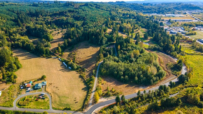
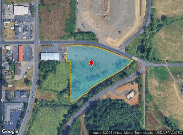

This Property Is For Sale
NEARBY LISTINGS FOR SALE OR LEASE
-
-
-
No Photo
-
-
View all Centralia listings for sale on LoopNet.com
Property Detail
Fair St
Other Market Areas
Tract 1
Centralia, WA
SECTION 17 TOWNSHIP 14N RANGE 02W PT SE4 NE4 & NE4 SE4 BEING TRACT 1 BLA 2020-0668 3540427
003417-048-131
Lewis
Residentialacreage
Washington
2024
3.72 AC
2025
Washington State Area
970500
DEMOGRAPHICS near Fair St
1 Mile
3 Mile
5 Mile
2024 Total Population
3,018
25,065
37,806
2029 Population
3,147
25,974
39,162
Pop Growth 2024-2029
+ 4.27%
+ 3.63%
+ 3.59%
Average Age
37
40
40
2024 Total Households
1,131
9,698
14,442
HH Growth 2024-2029
+ 4.33%
+ 3.60%
+ 3.57%
Median Household Inc
$64,235
$63,977
$65,429
Avg Household Size
2.60
2.50
2.50
2024 Avg HH Vehicles
2.00
2.00
2.00
Median Home Value
$375,297
$353,110
$360,287
Median Year Built
1964
1974
1976
Nearby Places
- Restaurants
- Banks
- Shops
- Fitness
- Groceries
PUBLIC TRANSPORTATION
COMMUTER RAIL
Centralia Amtrak Station (Amtrak Cascades - Amtrak, Coast Starlight - Amtrak)
DRIVE
WALK
Distance
Centralia Amtrak Station (Amtrak Cascades - Amtrak, Coast Starlight - Amtrak)
3 min
1.5 mi
Freight Ports
Port of Long View, WA
DRIVE
WALK
Distance
Port of Long View, WA
60 min
45.8 mi
Nearby Properties
Address
Land Use
TOTAL SIZE
Lot Size
Zoning
Address
Land Use
TOTAL SIZE
Lot Size
Zoning
19,200 SF
3.12 AC
ILCG
Address
Land Use
TOTAL SIZE
Lot Size
Zoning
2,003 SF
27.85 AC
LBD
Address
Land Use
TOTAL SIZE
Lot Size
Zoning
Address
Land Use
TOTAL SIZE
Lot Size
Zoning
10,848 SF
2.08 AC
EPFG
Address
Land Use
TOTAL SIZE
Lot Size
Zoning
1,714 SF
220.30 AC
EPFA
Address
Land Use
TOTAL SIZE
Lot Size
Zoning
222,077 SF
Address
Land Use
TOTAL SIZE
Lot Size
Zoning
2,956 SF
4.99 AC
R15
Address
Land Use
TOTAL SIZE
Lot Size
Zoning
64,421 SF
5 AC
H1
Address
Land Use
TOTAL SIZE
Lot Size
Zoning
7,168 SF
4.10 AC
OSPF
Address
Land Use
TOTAL SIZE
Lot Size
Zoning
43,477 SF
8.64 AC
CG
Address
Land Use
TOTAL SIZE
Lot Size
Zoning
57,621 SF
5.33 AC
H1
Address
Land Use
TOTAL SIZE
Lot Size
Zoning
1.03 AC
C1
Address
Land Use
TOTAL SIZE
Lot Size
Zoning
29,204 SF
3.91 AC
R20
Address
Land Use
TOTAL SIZE
Lot Size
Zoning
75,993 SF
18.76 AC
PMP
Address
Land Use
TOTAL SIZE
Lot Size
Zoning
34,150 SF
7.20 AC
CG
Address
Land Use
TOTAL SIZE
Lot Size
Zoning
Address
Land Use
TOTAL SIZE
Lot Size
Zoning
Address
Land Use
TOTAL SIZE
Lot Size
Zoning
3,196 SF
4.48 AC
R15
Address
Land Use
TOTAL SIZE
Lot Size
Zoning
48,865 SF
4.70 AC
H1
Address
Land Use
TOTAL SIZE
Lot Size
Zoning
104,872 SF
Address
Land Use
TOTAL SIZE
Lot Size
Zoning
4,361 SF
5.41 AC
R2
Address
Land Use
TOTAL SIZE
Lot Size
Zoning
94,044 SF
Address
Land Use
TOTAL SIZE
Lot Size
Zoning
Address
Land Use
TOTAL SIZE
Lot Size
Zoning
3,536 SF
1.73 AC
R20
Address
Land Use
TOTAL SIZE
Lot Size
Zoning
83,043 SF
6.76 AC
CG
Address
Land Use
TOTAL SIZE
Lot Size
Zoning
1,512 SF
8.64 AC
OSPF
Address
Land Use
TOTAL SIZE
Lot Size
Zoning
21,672 SF
2.08 AC
R20
Address
Land Use
TOTAL SIZE
Lot Size
Zoning
864 SF
45.31 AC
OSPF
Address
Land Use
TOTAL SIZE
Lot Size
Zoning
1,161 SF
2.11 AC
R15
Address
Land Use
TOTAL SIZE
Lot Size
Zoning
2,088 SF
1.48 AC
R15
The World's #1 Commercial Real Estate Marketplace
Connect with us
© 2025 CoStar Group
The information above has been obtained from sources believed reliable. While we do not doubt its accuracy we have not verified it and make no guarantee, warranty or representation about it. It is your responsibility to independently confirm its accuracy and completeness. Any projections, opinions, assumptions, or estimates used are for example only and do not represent the current or future performance of the property. The value of this transaction to you depends on tax and other factors which should be evaluated by your tax, financial, and legal advisors. You and your advisors should conduct a careful, independent investigation of the property to determine to your satisfaction the suitability of the property for your needs.