Property Record
Sand Ridge Rd, Hubert, NC 28539
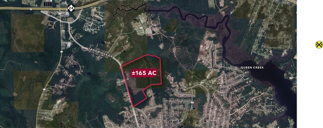

This Property Is For Sale
Property Detail
Sand Ridge Rd
032202
SR 1501
Residentialacreage
ONSLOW
R-8M
North Carolina
AE The base floodplain where base flood elevations are provided. AE Zones are now used on new format FIRMs instead of A1-A30 Zones.
168.18 AC
2025
Coastal Carolina
2025
Other Market Areas
002803
Jacksonville, NC
NEARBY LISTINGS FOR SALE OR LEASE
DEMOGRAPHICS near Sand Ridge Rd
1 mile
3 mile
5 mile
2025 Total Population
2,293
17,995
26,193
2030 Population
2,432
18,951
27,733
Pop Growth 2025-2030
+ 6.06%
+ 5.31%
+ 5.88%
Average Age
33
34
36
2025 Total Households
871
6,041
9,391
HH Growth 2025-2030
+ 6.31%
+ 6.12%
+ 6.56%
Median Household Inc
$61,277
$69,918
$72,827
Avg Household Size
2.60
2.60
2.50
2025 Avg HH Vehicles
2.00
2.00
2.00
Median Home Value
$223,110
$253,566
$278,713
Median Year Built
1999
1999
1999
Nearby Places
Map Layers
Map Styles
 Street
 Aerial
Transit
 Traffic
 Biking
Places
Listings with unknown addresses are not visible on the map
- Restaurants
- Banks
- Shops
- Fitness
- Groceries
PUBLIC TRANSPORTATION
AIRPORT
Albert J Ellis
Drive
Walk
Distance
Albert J Ellis
53 min
28.7 mi
Coastal Carolina Regional
Drive
Walk
Distance
Coastal Carolina Regional
70 min
44.8 mi
Freight Ports
Port of Morehead City
Drive
Walk
Distance
Port of Morehead City
61 min
34.5 mi
Nearby Properties
Address
Land Use
TOTAL SIZE
Lot Size
Zoning
Address
Land Use
TOTAL SIZE
Lot Size
Zoning
77,063 SF
50.22 AC
RA
Address
Land Use
TOTAL SIZE
Lot Size
Zoning
73,855 SF
7.51 AC
RA
Address
Land Use
TOTAL SIZE
Lot Size
Zoning
10,350 SF
22.80 AC
HB
Address
Land Use
TOTAL SIZE
Lot Size
Zoning
1,320 SF
59.95 AC
CB
Address
Land Use
TOTAL SIZE
Lot Size
Zoning
45,900 SF
7.96 AC
RA(CZ)
Address
Land Use
TOTAL SIZE
Lot Size
Zoning
218.40 AC
R-15
Address
Land Use
TOTAL SIZE
Lot Size
Zoning
1,325 SF
17.24 AC
HB
Address
Land Use
TOTAL SIZE
Lot Size
Zoning
2,000 SF
6.29 AC
HB
Address
Land Use
TOTAL SIZE
Lot Size
Zoning
55.80 AC
R-8M
Address
Land Use
TOTAL SIZE
Lot Size
Zoning
4,050 SF
45.50 AC
HB
Address
Land Use
TOTAL SIZE
Lot Size
Zoning
13.04 AC
HB
Address
Land Use
TOTAL SIZE
Lot Size
Zoning
9,100 SF
2.37 AC
HB
Address
Land Use
TOTAL SIZE
Lot Size
Zoning
9,020 SF
1.18 AC
CB
Address
Land Use
TOTAL SIZE
Lot Size
Zoning
8,400 SF
1.77 AC
RA
Address
Land Use
TOTAL SIZE
Lot Size
Zoning
5,506 SF
77.23 AC
RA
Address
Land Use
TOTAL SIZE
Lot Size
Zoning
4,141 SF
2.33 AC
R-15
Address
Land Use
TOTAL SIZE
Lot Size
Zoning
6,237 SF
2.06 AC
HB
Address
Land Use
TOTAL SIZE
Lot Size
Zoning
10,803 SF
3.90 AC
RA
Address
Land Use
TOTAL SIZE
Lot Size
Zoning
21.51 AC
HB
Address
Land Use
TOTAL SIZE
Lot Size
Zoning
3,367 SF
2.09 AC
HB
Address
Land Use
TOTAL SIZE
Lot Size
Zoning
8,990 SF
2.32 AC
HB
Address
Land Use
TOTAL SIZE
Lot Size
Zoning
7,548 SF
1.66 AC
R-8M
Address
Land Use
TOTAL SIZE
Lot Size
Zoning
8,106 SF
4.70 AC
R-8M
Address
Land Use
TOTAL SIZE
Lot Size
Zoning
11,131 SF
2 AC
R-8M
Address
Land Use
TOTAL SIZE
Lot Size
Zoning
59.77 AC
HB
Address
Land Use
TOTAL SIZE
Lot Size
Zoning
95.89 AC
R-8M
Address
Land Use
TOTAL SIZE
Lot Size
Zoning
4,000 SF
1.65 AC
CB
Address
Land Use
TOTAL SIZE
Lot Size
Zoning
5,400 SF
1.42 AC
HB
Address
Land Use
TOTAL SIZE
Lot Size
Zoning
40.72 AC
RA
Address
Land Use
TOTAL SIZE
Lot Size
Zoning
3,120 SF
4.38 AC
R-8M
The World's #1 Commercial Real Estate Marketplace
Connect with us
© 2026 CoStar Group
The information above has been obtained from sources believed reliable. While we do not doubt its accuracy we have not verified it and make no guarantee, warranty or representation about it. It is your responsibility to independently confirm its accuracy and completeness. Any projections, opinions, assumptions, or estimates used are for example only and do not represent the current or future performance of the property. The value of this transaction to you depends on tax and other factors which should be evaluated by your tax, financial, and legal advisors. You and your advisors should conduct a careful, independent investigation of the property to determine to your satisfaction the suitability of the property for your needs.