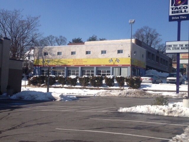
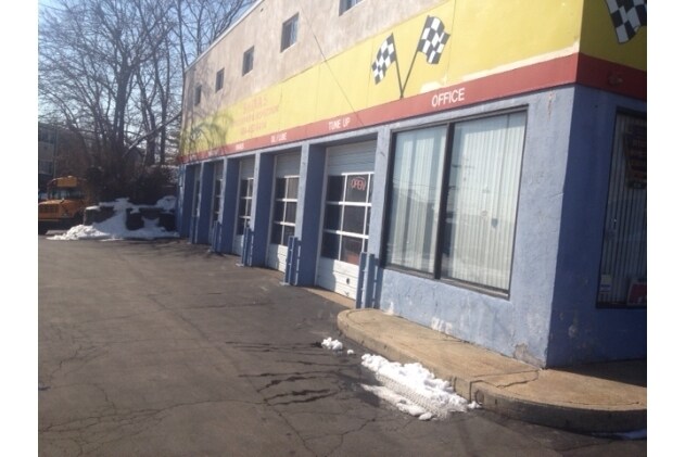
Property Record
0 State Rd, Upper Darby, PA 19082

Property Detail
0 State Rd
16-07-00810-00
2 STY BLDG 77 X 125 IRR
Autorepair
DELAWARE
B and X Area of moderate flood hazard, usually the area between the limits of the 100-year and 500-year floods.
Pennsylvania
2024
0.12 AC
2025
Delaware County
400700
Philadelphia
4,292 SF
Philadelphia-Camden-Wilmington, PA-NJ-DE-MD
NEARBY LISTINGS FOR SALE OR LEASE
DEMOGRAPHICS near 0 State Rd
1 mile
3 mile
5 mile
2024 Total Population
39,296
314,652
651,707
2029 Population
39,374
315,182
655,677
Pop Growth 2024-2029
+ 0.20%
+ 0.17%
+ 0.61%
Average Age
38
39
39
2024 Total Households
14,272
120,772
254,651
HH Growth 2024-2029
+ 0.24%
+ 0.05%
+ 0.50%
Median Household Inc
$62,651
$62,784
$64,726
Avg Household Size
2.60
2.50
2.40
2024 Avg HH Vehicles
1.00
1.00
1.00
Median Home Value
$177,929
$228,528
$268,689
Median Year Built
1948
1947
1949
Nearby Places
Map Layers
Map Styles
 Street
 Aerial
Transit
 Traffic
 Biking
Places
Listings with unknown addresses are not visible on the map
- Restaurants
- Banks
- Shops
- Fitness
- Groceries
PUBLIC TRANSPORTATION
TRANSIT/SUBWAY
Walnut Street (Route 101 - Southeastern Pennsylvania Transportation Authority Rapid Transit (SEPTA Subway & Trolley), Route 102 - Southeastern Pennsylvania Transportation Authority Rapid Transit (SEPTA Subway & Trolley))
Drive
Walk
Distance
Walnut Street (Route 101 - Southeastern Pennsylvania Transportation Authority Rapid Transit (SEPTA Subway & Trolley), Route 102 - Southeastern Pennsylvania Transportation Authority Rapid Transit (SEPTA Subway & Trolley))
2 min
10 min
0.5 mi
Avon Road (Route 101 - Southeastern Pennsylvania Transportation Authority Rapid Transit (SEPTA Subway & Trolley), Route 102 - Southeastern Pennsylvania Transportation Authority Rapid Transit (SEPTA Subway & Trolley))
Drive
Walk
Distance
Avon Road (Route 101 - Southeastern Pennsylvania Transportation Authority Rapid Transit (SEPTA Subway & Trolley), Route 102 - Southeastern Pennsylvania Transportation Authority Rapid Transit (SEPTA Subway & Trolley))
2 min
10 min
0.5 mi
Fairfield Avenue (Route 101 - Southeastern Pennsylvania Transportation Authority Rapid Transit (SEPTA Subway & Trolley), Route 102 - Southeastern Pennsylvania Transportation Authority Rapid Transit (SEPTA Subway & Trolley))
Drive
Walk
Distance
Fairfield Avenue (Route 101 - Southeastern Pennsylvania Transportation Authority Rapid Transit (SEPTA Subway & Trolley), Route 102 - Southeastern Pennsylvania Transportation Authority Rapid Transit (SEPTA Subway & Trolley))
2 min
11 min
0.6 mi
Parkview (Route 100 - Southeastern Pennsylvania Transportation Authority Rapid Transit (SEPTA Subway & Trolley))
Drive
Walk
Distance
Parkview (Route 100 - Southeastern Pennsylvania Transportation Authority Rapid Transit (SEPTA Subway & Trolley))
5 min
14 min
0.7 mi
Beverly Boulevard (Route 101 - Southeastern Pennsylvania Transportation Authority Rapid Transit (SEPTA Subway & Trolley), Route 102 - Southeastern Pennsylvania Transportation Authority Rapid Transit (SEPTA Subway & Trolley))
Drive
Walk
Distance
Beverly Boulevard (Route 101 - Southeastern Pennsylvania Transportation Authority Rapid Transit (SEPTA Subway & Trolley), Route 102 - Southeastern Pennsylvania Transportation Authority Rapid Transit (SEPTA Subway & Trolley))
3 min
17 min
0.9 mi
COMMUTER RAIL
Fernwood-Yeadon (R3 - Southeastern Pennsylvania Transportation Authority Regional Rail (SEPTA Regional Rail))
Drive
Walk
Distance
Fernwood-Yeadon (R3 - Southeastern Pennsylvania Transportation Authority Regional Rail (SEPTA Regional Rail))
7 min
2.3 mi
Lansdowne (R3 - Southeastern Pennsylvania Transportation Authority Regional Rail (SEPTA Regional Rail))
Drive
Walk
Distance
Lansdowne (R3 - Southeastern Pennsylvania Transportation Authority Regional Rail (SEPTA Regional Rail))
8 min
2.9 mi
AIRPORT
Philadelphia International
Drive
Walk
Distance
Philadelphia International
22 min
8.5 mi
Trenton Mercer
Drive
Walk
Distance
Trenton Mercer
63 min
40.3 mi
Freight Ports
South Jersey Port
Drive
Walk
Distance
South Jersey Port
24 min
10.9 mi
Nearby Properties
Address
Land Use
TOTAL SIZE
Lot Size
Zoning
Address
Land Use
TOTAL SIZE
Lot Size
Zoning
2,178,860 SF
48.65 AC
R3
Address
Land Use
TOTAL SIZE
Lot Size
Zoning
158,496 SF
Address
Land Use
TOTAL SIZE
Lot Size
Zoning
175,069 SF
2.20 AC
CMX3
Address
Land Use
TOTAL SIZE
Lot Size
Zoning
1,600 SF
177.07 AC
SPPOA
Address
Land Use
TOTAL SIZE
Lot Size
Zoning
511,806 SF
1.70 AC
RM4
Address
Land Use
TOTAL SIZE
Lot Size
Zoning
15,660 SF
56.60 AC
Address
Land Use
TOTAL SIZE
Lot Size
Zoning
461,834 SF
4.73 AC
CMX3
Address
Land Use
TOTAL SIZE
Lot Size
Zoning
448,864 SF
32.89 AC
Address
Land Use
TOTAL SIZE
Lot Size
Zoning
112,268 SF
28.27 AC
Address
Land Use
TOTAL SIZE
Lot Size
Zoning
281,508 SF
18.93 AC
SPINS
Address
Land Use
TOTAL SIZE
Lot Size
Zoning
530,525 SF
36.29 AC
R3
Address
Land Use
TOTAL SIZE
Lot Size
Zoning
475,984 SF
5.74 AC
ICMX
Address
Land Use
TOTAL SIZE
Lot Size
Zoning
82,153 SF
13.97 AC
Address
Land Use
TOTAL SIZE
Lot Size
Zoning
1.65 AC
CMX3
Address
Land Use
TOTAL SIZE
Lot Size
Zoning
180,000 SF
0.57 AC
RM4
Address
Land Use
TOTAL SIZE
Lot Size
Zoning
7.96 AC
Address
Land Use
TOTAL SIZE
Lot Size
Zoning
164,640 SF
0.62 AC
CMX4
Address
Land Use
TOTAL SIZE
Lot Size
Zoning
390,000 SF
17.57 AC
SPINS
Address
Land Use
TOTAL SIZE
Lot Size
Zoning
20,880 SF
27.20 AC
Address
Land Use
TOTAL SIZE
Lot Size
Zoning
321,744 SF
14 AC
C1
Address
Land Use
TOTAL SIZE
Lot Size
Zoning
454,536 SF
26.63 AC
Address
Land Use
TOTAL SIZE
Lot Size
Zoning
93,353 SF
1.03 AC
CMX2.5
Address
Land Use
TOTAL SIZE
Lot Size
Zoning
170,880 SF
17.34 AC
CA2
Address
Land Use
TOTAL SIZE
Lot Size
Zoning
252,350 SF
0.91 AC
SPINS
Address
Land Use
TOTAL SIZE
Lot Size
Zoning
131,980 SF
9.17 AC
Address
Land Use
TOTAL SIZE
Lot Size
Zoning
131,200 SF
2.19 AC
RM4
Address
Land Use
TOTAL SIZE
Lot Size
Zoning
114,058 SF
3.20 AC
Address
Land Use
TOTAL SIZE
Lot Size
Zoning
746,701 SF
71.71 AC
R3
Address
Land Use
TOTAL SIZE
Lot Size
Zoning
128,453 SF
1.21 AC
ICMX
Address
Land Use
TOTAL SIZE
Lot Size
Zoning
75,500 SF
0.80 AC
CMX3
The World's #1 Commercial Real Estate Marketplace
Connect with us
© 2026 CoStar Group
The information above has been obtained from sources believed reliable. While we do not doubt its accuracy we have not verified it and make no guarantee, warranty or representation about it. It is your responsibility to independently confirm its accuracy and completeness. Any projections, opinions, assumptions, or estimates used are for example only and do not represent the current or future performance of the property. The value of this transaction to you depends on tax and other factors which should be evaluated by your tax, financial, and legal advisors. You and your advisors should conduct a careful, independent investigation of the property to determine to your satisfaction the suitability of the property for your needs.