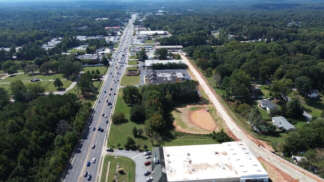
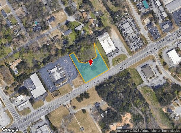
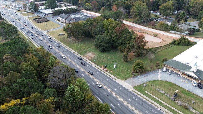
Property Record
Stone Mountain Hwy, Snellville, GA 30039
NEARBY LISTINGS FOR SALE OR LEASE
Property Detail
Stone Mountain Hwy
Atlanta-Sandy Springs-Roswell, GA
Hwy 78
6-053-051
US HWY 78
Commercialacreage
Gwinnett
X
Georgia
13135C0136F
3
2025
1.60 AC
2025
Lawrenceville/Lilburn
050734
Atlanta
DEMOGRAPHICS near Stone Mountain Hwy
1 Mile
3 Mile
5 Mile
2024 Total Population
9,264
64,958
168,918
2029 Population
9,682
67,597
175,816
Pop Growth 2024-2029
+ 4.51%
+ 4.06%
+ 4.08%
Average Age
36
38
39
2024 Total Households
3,147
21,222
54,633
HH Growth 2024-2029
+ 4.54%
+ 4.13%
+ 4.12%
Median Household Inc
$69,388
$88,269
$89,590
Avg Household Size
2.80
3.00
3.00
2024 Avg HH Vehicles
2.00
2.00
2.00
Median Home Value
$257,452
$288,520
$293,324
Median Year Built
1987
1986
1987
Nearby Places
Map Layers
Map Styles
 Street
 Aerial
- Restaurants
- Banks
- Shops
- Fitness
- Groceries
PUBLIC TRANSPORTATION
AIRPORT
Hartsfield - Jackson Atlanta International
DRIVE
WALK
Distance
Hartsfield - Jackson Atlanta International
45 min
30.6 mi
Freight Ports
Georgia Ports - Savannah
DRIVE
WALK
Distance
Georgia Ports - Savannah
298 min
262.4 mi
SALE & LEASE HISTORY
LISTING DATE
SALE/LEASE

Oct 31, 2024
For Sale
Jun 06, 2019
For Sale
Nearby Properties
Address
Land Use
TOTAL SIZE
Lot Size
Zoning
Address
Land Use
TOTAL SIZE
Lot Size
Zoning
301,646 SF
23.90 AC
RM13
Address
Land Use
TOTAL SIZE
Lot Size
Zoning
462,669 SF
102.65 AC
R100
Address
Land Use
TOTAL SIZE
Lot Size
Zoning
469,566 SF
24.30 AC
RS180
Address
Land Use
TOTAL SIZE
Lot Size
Zoning
319,290 SF
2.05 AC
TC-MU
Address
Land Use
TOTAL SIZE
Lot Size
Zoning
278,756 SF
27.72 AC
RM
Address
Land Use
TOTAL SIZE
Lot Size
Zoning
230,417 SF
24.09 AC
BG
Address
Land Use
TOTAL SIZE
Lot Size
Zoning
283,953 SF
20.56 AC
RS30
Address
Land Use
TOTAL SIZE
Lot Size
Zoning
175,045 SF
13.01 AC
RM
Address
Land Use
TOTAL SIZE
Lot Size
Zoning
357,243 SF
59.63 AC
R100
Address
Land Use
TOTAL SIZE
Lot Size
Zoning
113,100 SF
11.39 AC
C2
Address
Land Use
TOTAL SIZE
Lot Size
Zoning
38,438 SF
130.10 AC
R100
Address
Land Use
TOTAL SIZE
Lot Size
Zoning
139,448 SF
15.97 AC
RM
Address
Land Use
TOTAL SIZE
Lot Size
Zoning
202,864 SF
1.35 AC
TC-MU
Address
Land Use
TOTAL SIZE
Lot Size
Zoning
217,730 SF
29.68 AC
C2
Address
Land Use
TOTAL SIZE
Lot Size
Zoning
79,339 SF
38.25 AC
RS180
Address
Land Use
TOTAL SIZE
Lot Size
Zoning
120,113 SF
13 AC
BG
Address
Land Use
TOTAL SIZE
Lot Size
Zoning
99,280 SF
4.51 AC
C2
Address
Land Use
TOTAL SIZE
Lot Size
Zoning
106,114 SF
16.59 AC
C2
Address
Land Use
TOTAL SIZE
Lot Size
Zoning
97,411 SF
8.47 AC
BG
Address
Land Use
TOTAL SIZE
Lot Size
Zoning
111,732 SF
9.71 AC
CI
Address
Land Use
TOTAL SIZE
Lot Size
Zoning
89,686 SF
18.29 AC
C2
Address
Land Use
TOTAL SIZE
Lot Size
Zoning
103,821 SF
10.80 AC
M1
Address
Land Use
TOTAL SIZE
Lot Size
Zoning
44,452 SF
0.68 AC
TC-MU
Address
Land Use
TOTAL SIZE
Lot Size
Zoning
48,985 SF
17.87 AC
C2
Address
Land Use
TOTAL SIZE
Lot Size
Zoning
57,322 SF
9.18 AC
C2
Address
Land Use
TOTAL SIZE
Lot Size
Zoning
77,284 SF
3.93 AC
C2
Address
Land Use
TOTAL SIZE
Lot Size
Zoning
91,096 SF
28.67 AC
OI
Address
Land Use
TOTAL SIZE
Lot Size
Zoning
100,000 SF
10.39 AC
C2
Address
Land Use
TOTAL SIZE
Lot Size
Zoning
99,893 SF
7.48 AC
OI
Address
Land Use
TOTAL SIZE
Lot Size
Zoning
52,262 SF
6.02 AC
C3
The World's #1 Commercial Real Estate Marketplace
Connect with us
© 2026 CoStar Group
The information above has been obtained from sources believed reliable. While we do not doubt its accuracy we have not verified it and make no guarantee, warranty or representation about it. It is your responsibility to independently confirm its accuracy and completeness. Any projections, opinions, assumptions, or estimates used are for example only and do not represent the current or future performance of the property. The value of this transaction to you depends on tax and other factors which should be evaluated by your tax, financial, and legal advisors. You and your advisors should conduct a careful, independent investigation of the property to determine to your satisfaction the suitability of the property for your needs.