Property Record
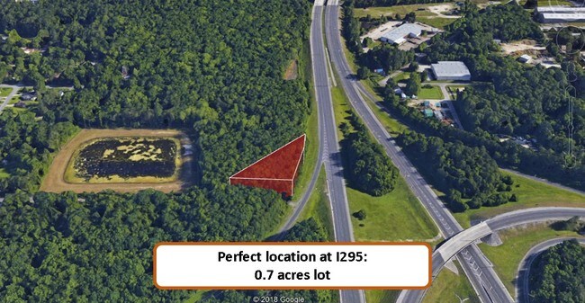
0 Stuart Ave, Jacksonville, FL 32220

Property Detail
0 Stuart Ave
007420-0000
14-32 38-2S-25E .697 CHASE HEIGHTS 2 PT TRACT 7 RECD D BK 837-265 LYING W OF I-295(EX PT RECD O/R 2948-1100)
Industrialacreage
DUVAL
IL
Florida
B and X Area of moderate flood hazard, usually the area between the limits of the 100-year and 500-year floods.
0.68 AC
2025
Northwest Jacksonville
2026
Jacksonville (Florida)
011901
Jacksonville, FL
NEARBY LISTINGS FOR SALE OR LEASE
-
-
-
-
-
-
-
-
-
-
-
-
-
-
-
-
No Photo
-
View all Jacksonville listings for sale on LoopNet.com
DEMOGRAPHICS near 0 Stuart Ave
1 mile
3 mile
5 mile
2025 Total Population
4,533
48,897
150,062
2030 Population
4,847
52,114
159,551
Pop Growth 2025-2030
+ 6.93%
+ 6.58%
+ 6.32%
Average Age
39
39
39
2025 Total Households
1,706
19,079
59,988
HH Growth 2025-2030
+ 7.09%
+ 6.89%
+ 6.61%
Median Household Inc
$49,510
$57,414
$60,858
Avg Household Size
2.50
2.50
2.40
2025 Avg HH Vehicles
2.00
2.00
2.00
Median Home Value
$183,812
$239,002
$253,038
Median Year Built
1968
1975
1971
Nearby Places
Map Layers
Map Styles
 Street
 Aerial
Transit
 Traffic
 Biking
Places
Listings with unknown addresses are not visible on the map
- Restaurants
- Banks
- Shops
- Fitness
- Groceries
PUBLIC TRANSPORTATION
COMMUTER RAIL
Jacksonville (Silver Meteor - Amtrak, Silver Star - Amtrak)
Drive
Walk
Distance
Jacksonville (Silver Meteor - Amtrak, Silver Star - Amtrak)
17 min
9.7 mi
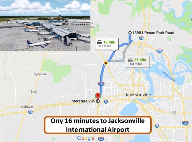
AIRPORT
Jacksonville International
Drive
Walk
Distance
Jacksonville International
30 min
20.2 mi
Freight Ports
Jacksonville Port
Drive
Walk
Distance
Jacksonville Port
22 min
14.0 mi
SALE & LEASE HISTORY
LISTING DATE
SALE/LEASE

Apr 30, 2019
For Sale
Nearby Properties
Address
Land Use
TOTAL SIZE
Lot Size
Zoning
Address
Land Use
TOTAL SIZE
Lot Size
Zoning
744,280 SF
53.40 AC
RMD-D
Address
Land Use
TOTAL SIZE
Lot Size
Zoning
600,857 SF
38.14 AC
IL
Address
Land Use
TOTAL SIZE
Lot Size
Zoning
506,816 SF
39.32 AC
IBP
Address
Land Use
TOTAL SIZE
Lot Size
Zoning
874,178 SF
46.91 AC
PBF-2
Address
Land Use
TOTAL SIZE
Lot Size
Zoning
465,664 SF
21.27 AC
IL
Address
Land Use
TOTAL SIZE
Lot Size
Zoning
888,083 SF
46.65 AC
IL
Address
Land Use
TOTAL SIZE
Lot Size
Zoning
352,439 SF
3.40 AC
CCBD
Address
Land Use
TOTAL SIZE
Lot Size
Zoning
397,865 SF
42 AC
IL
Address
Land Use
TOTAL SIZE
Lot Size
Zoning
321,547 SF
17.17 AC
PUD
Address
Land Use
TOTAL SIZE
Lot Size
Zoning
222,138 SF
13.18 AC
IL
Address
Land Use
TOTAL SIZE
Lot Size
Zoning
505,748 SF
94.71 AC
IL
Address
Land Use
TOTAL SIZE
Lot Size
Zoning
594,573 SF
27.69 AC
IL
Address
Land Use
TOTAL SIZE
Lot Size
Zoning
290,599 SF
27.84 AC
RMD-D
Address
Land Use
TOTAL SIZE
Lot Size
Zoning
310,972 SF
19.91 AC
RMD-D
Address
Land Use
TOTAL SIZE
Lot Size
Zoning
233,363 SF
20.36 AC
PUD
Address
Land Use
TOTAL SIZE
Lot Size
Zoning
481,686 SF
43.54 AC
IL
Address
Land Use
TOTAL SIZE
Lot Size
Zoning
64,013 SF
8.37 AC
PUD
Address
Land Use
TOTAL SIZE
Lot Size
Zoning
196,790 SF
12.62 AC
RMD-D
Address
Land Use
TOTAL SIZE
Lot Size
Zoning
240,410 SF
16.76 AC
IL
Address
Land Use
TOTAL SIZE
Lot Size
Zoning
169,370 SF
10.87 AC
RMD-D
Address
Land Use
TOTAL SIZE
Lot Size
Zoning
323,261 SF
56.62 AC
IL
Address
Land Use
TOTAL SIZE
Lot Size
Zoning
162,283 SF
14.29 AC
IL
Address
Land Use
TOTAL SIZE
Lot Size
Zoning
161,001 SF
10.32 AC
IL
Address
Land Use
TOTAL SIZE
Lot Size
Zoning
209,480 SF
22.42 AC
CCG-1
Address
Land Use
TOTAL SIZE
Lot Size
Zoning
114,316 SF
20.57 AC
IL
Address
Land Use
TOTAL SIZE
Lot Size
Zoning
279,053 SF
21.03 AC
IBP
Address
Land Use
TOTAL SIZE
Lot Size
Zoning
170,550 SF
7.48 AC
IL
Address
Land Use
TOTAL SIZE
Lot Size
Zoning
167,854 SF
8.01 AC
IL
Address
Land Use
TOTAL SIZE
Lot Size
Zoning
269,178 SF
129.93 AC
PBF-2
Address
Land Use
TOTAL SIZE
Lot Size
Zoning
296,340 SF
10.63 AC
IL
The World's #1 Commercial Real Estate Marketplace
Connect with us
© 2026 CoStar Group
The information above has been obtained from sources believed reliable. While we do not doubt its accuracy we have not verified it and make no guarantee, warranty or representation about it. It is your responsibility to independently confirm its accuracy and completeness. Any projections, opinions, assumptions, or estimates used are for example only and do not represent the current or future performance of the property. The value of this transaction to you depends on tax and other factors which should be evaluated by your tax, financial, and legal advisors. You and your advisors should conduct a careful, independent investigation of the property to determine to your satisfaction the suitability of the property for your needs.