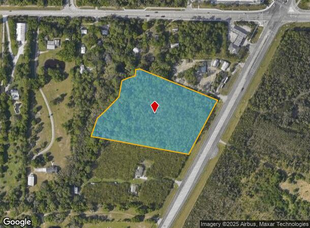
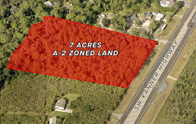
Property Record
0 Sw Kanner Hwy, Stuart, FL 34994

NEARBY LISTINGS FOR SALE OR LEASE
Property Detail
0 Sw Kanner Hwy
Port St Lucie, FL
Tropical Fruit Farms
18-39-41-000-003-00040-0
18 39 41 TROPICAL FRUIT FARMS BEG S/LN LOT 3 & W R/W SR 76 NELY 420.27 FOR BEG NELY ALG R/W 420.27 TO C/LN SRD DITCH NWLY ALG C/LN 596.53 TO C/LN OF CREEK MEANDER SWLY TO LN 79 DEG 03 34 W FROM BEG & SELY 655 TO BEG
Recreationalacreage
Martin
AE
Florida
12085C0284H
3
2024
7 AC
2025
Martin Inland
000701
Port St Lucie/Fort Pierce
DEMOGRAPHICS near 0 Sw Kanner Hwy
1 Mile
3 Mile
5 Mile
2024 Total Population
2,908
8,856
21,698
2029 Population
2,999
9,121
22,424
Pop Growth 2024-2029
+ 3.13%
+ 2.99%
+ 3.35%
Average Age
48
48
48
2024 Total Households
1,170
3,578
8,838
HH Growth 2024-2029
+ 2.91%
+ 2.82%
+ 3.33%
Median Household Inc
$64,476
$83,457
$83,437
Avg Household Size
2.40
2.40
2.40
2024 Avg HH Vehicles
2.00
2.00
2.00
Median Home Value
$335,084
$394,397
$394,658
Median Year Built
1996
1995
1994
Nearby Places
Map Layers
Map Styles
 Street
 Aerial
- Restaurants
- Banks
- Shops
- Fitness
- Groceries
SALE & LEASE HISTORY
LISTING DATE
SALE/LEASE

Jan 27, 2023
For Sale
Nearby Properties
Address
Land Use
TOTAL SIZE
Lot Size
Zoning
Address
Land Use
TOTAL SIZE
Lot Size
Zoning
49.11 AC
Address
Land Use
TOTAL SIZE
Lot Size
Zoning
20.76 AC
Address
Land Use
TOTAL SIZE
Lot Size
Zoning
6,510 SF
1,216.20 AC
A2
Address
Land Use
TOTAL SIZE
Lot Size
Zoning
16.75 AC
Address
Land Use
TOTAL SIZE
Lot Size
Zoning
17.29 AC
Address
Land Use
TOTAL SIZE
Lot Size
Zoning
39,801 SF
8.50 AC
LI
Address
Land Use
TOTAL SIZE
Lot Size
Zoning
56,281 SF
28.86 AC
LI
Address
Land Use
TOTAL SIZE
Lot Size
Zoning
69,133 SF
6 AC
PUDC
Address
Land Use
TOTAL SIZE
Lot Size
Zoning
97,783 SF
6.34 AC
LI
Address
Land Use
TOTAL SIZE
Lot Size
Zoning
190,638 SF
147 AC
A1
Address
Land Use
TOTAL SIZE
Lot Size
Zoning
8,630 SF
24.45 AC
PUDC
Address
Land Use
TOTAL SIZE
Lot Size
Zoning
5.52 AC
LI
Address
Land Use
TOTAL SIZE
Lot Size
Zoning
44,712 SF
15.18 AC
PS2
Address
Land Use
TOTAL SIZE
Lot Size
Zoning
47,906 SF
28.52 AC
RE2A
Address
Land Use
TOTAL SIZE
Lot Size
Zoning
39,555 SF
2.47 AC
PUDC
Address
Land Use
TOTAL SIZE
Lot Size
Zoning
248.21 AC
A1
Address
Land Use
TOTAL SIZE
Lot Size
Zoning
51,969 SF
16.19 AC
GI
Address
Land Use
TOTAL SIZE
Lot Size
Zoning
2.99 AC
LI
Address
Land Use
TOTAL SIZE
Lot Size
Zoning
28,488 SF
181.84 AC
PR
Address
Land Use
TOTAL SIZE
Lot Size
Zoning
53,801 SF
7.30 AC
WGC
Address
Land Use
TOTAL SIZE
Lot Size
Zoning
11.97 AC
PUDC
Address
Land Use
TOTAL SIZE
Lot Size
Zoning
80,989 SF
31.75 AC
A1
Address
Land Use
TOTAL SIZE
Lot Size
Zoning
52,800 SF
3.78 AC
LI
Address
Land Use
TOTAL SIZE
Lot Size
Zoning
18,017 SF
1.38 AC
WGC
Address
Land Use
TOTAL SIZE
Lot Size
Zoning
29,700 SF
2.01 AC
LI
Address
Land Use
TOTAL SIZE
Lot Size
Zoning
36,000 SF
2.79 AC
LI
Address
Land Use
TOTAL SIZE
Lot Size
Zoning
27,209 SF
5.68 AC
M2
Address
Land Use
TOTAL SIZE
Lot Size
Zoning
62,120 SF
4.99 AC
LC
Address
Land Use
TOTAL SIZE
Lot Size
Zoning
29.60 AC
Address
Land Use
TOTAL SIZE
Lot Size
Zoning
13,762 SF
1.94 AC
COR1
The World's #1 Commercial Real Estate Marketplace
Connect with us
© 2025 CoStar Group
The information above has been obtained from sources believed reliable. While we do not doubt its accuracy we have not verified it and make no guarantee, warranty or representation about it. It is your responsibility to independently confirm its accuracy and completeness. Any projections, opinions, assumptions, or estimates used are for example only and do not represent the current or future performance of the property. The value of this transaction to you depends on tax and other factors which should be evaluated by your tax, financial, and legal advisors. You and your advisors should conduct a careful, independent investigation of the property to determine to your satisfaction the suitability of the property for your needs.