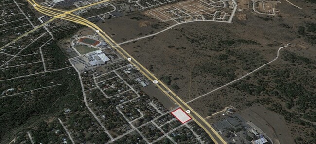
Property Record
0 Tbd, New Braunfels, TX 78130

Property Detail
0 Tbd
San Antonio-New Braunfels, TX
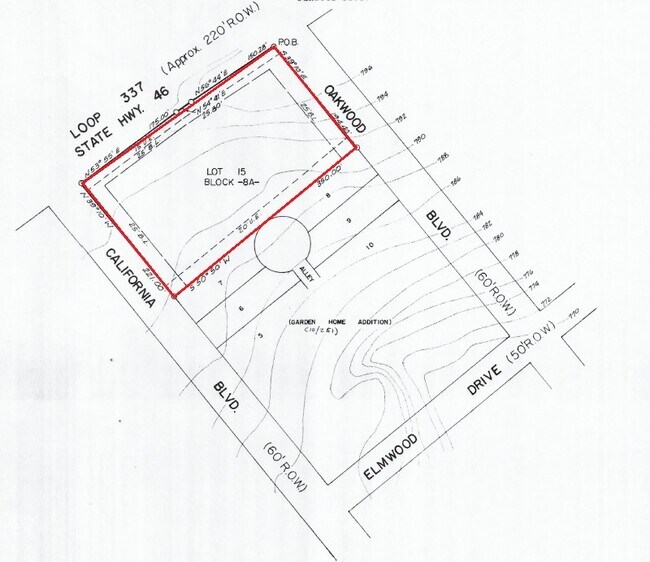
OAKWOOD ESTATES 5 GARDEN HOME ADDITION, BLOCK 8A, LOT 15
40-0560-0068-00
COMAL
Vacantlandnec
Texas
B and X Area of moderate flood hazard, usually the area between the limits of the 100-year and 500-year floods.
15
2024
1.66 AC
2025
Comal County
310100
San Antonio
NEARBY LISTINGS FOR SALE OR LEASE
DEMOGRAPHICS near 0 Tbd
1 mile
3 mile
5 mile
2025 Total Population
5,406
40,649
99,846
2030 Population
6,336
47,762
116,521
Pop Growth 2025-2030
+ 17.20%
+ 17.50%
+ 16.70%
Average Age
45
42
39
2025 Total Households
2,194
16,822
38,454
HH Growth 2025-2030
+ 17.27%
+ 17.58%
+ 16.96%
Median Household Inc
$102,659
$76,612
$89,862
Avg Household Size
2.30
2.30
2.50
2025 Avg HH Vehicles
2.00
2.00
2.00
Median Home Value
$542,112
$463,518
$377,230
Median Year Built
1995
1993
2005
Nearby Places
Map Layers
Map Styles
 Street
 Aerial
Layers
 Traffic
 Biking
Places
Listings with unknown addresses are not visible on the map
- Restaurants
- Banks
- Shops
- Fitness
- Groceries
PUBLIC TRANSPORTATION
AIRPORT
San Antonio International
Drive
Walk
Distance
San Antonio International
36 min
28.3 mi
SALE & LEASE HISTORY
LISTING DATE
SALE/LEASE

Sep 27, 2021
For Lease
Nearby Properties
Address
Land Use
TOTAL SIZE
Lot Size
Zoning
Address
Land Use
TOTAL SIZE
Lot Size
Zoning
111.44 AC
Address
Land Use
TOTAL SIZE
Lot Size
Zoning
350,595 SF
21.78 AC
Address
Land Use
TOTAL SIZE
Lot Size
Zoning
304,097 SF
14.98 AC
Address
Land Use
TOTAL SIZE
Lot Size
Zoning
433,083 SF
16.24 AC
Address
Land Use
TOTAL SIZE
Lot Size
Zoning
251,498 SF
8.63 AC
Address
Land Use
TOTAL SIZE
Lot Size
Zoning
325,518 SF
12.97 AC
Address
Land Use
TOTAL SIZE
Lot Size
Zoning
225,158 SF
52.63 AC
Address
Land Use
TOTAL SIZE
Lot Size
Zoning
170,266 SF
16.78 AC
Address
Land Use
TOTAL SIZE
Lot Size
Zoning
229,773 SF
11.18 AC
Address
Land Use
TOTAL SIZE
Lot Size
Zoning
103,782 SF
105.82 AC
Address
Land Use
TOTAL SIZE
Lot Size
Zoning
215,244 SF
11.38 AC
Address
Land Use
TOTAL SIZE
Lot Size
Zoning
282,995 SF
21.83 AC
Address
Land Use
TOTAL SIZE
Lot Size
Zoning
238,683 SF
9.42 AC
Address
Land Use
TOTAL SIZE
Lot Size
Zoning
102,856 SF
16.06 AC
Address
Land Use
TOTAL SIZE
Lot Size
Zoning
88,620 SF
10.11 AC
Address
Land Use
TOTAL SIZE
Lot Size
Zoning
152,240 SF
14.13 AC
Address
Land Use
TOTAL SIZE
Lot Size
Zoning
170,019 SF
4.46 AC
Address
Land Use
TOTAL SIZE
Lot Size
Zoning
105,976 SF
30.86 AC
Address
Land Use
TOTAL SIZE
Lot Size
Zoning
179,869 SF
10 AC
Address
Land Use
TOTAL SIZE
Lot Size
Zoning
188,600 SF
4.61 AC
Address
Land Use
TOTAL SIZE
Lot Size
Zoning
132,319 SF
8.80 AC
Address
Land Use
TOTAL SIZE
Lot Size
Zoning
97,200 SF
12.87 AC
Address
Land Use
TOTAL SIZE
Lot Size
Zoning
105,729 SF
12.66 AC
Address
Land Use
TOTAL SIZE
Lot Size
Zoning
165,768 SF
15.39 AC
Address
Land Use
TOTAL SIZE
Lot Size
Zoning
117,201 SF
4.72 AC
Address
Land Use
TOTAL SIZE
Lot Size
Zoning
61,079 SF
2.53 AC
Address
Land Use
TOTAL SIZE
Lot Size
Zoning
130,210 SF
13.57 AC
Address
Land Use
TOTAL SIZE
Lot Size
Zoning
127,491 SF
11 AC
Address
Land Use
TOTAL SIZE
Lot Size
Zoning
205,071 SF
23.66 AC
Address
Land Use
TOTAL SIZE
Lot Size
Zoning
93,699 SF
41.62 AC
The World's #1 Commercial Real Estate Marketplace
Connect with us
© 2026 CoStar Group
The information above has been obtained from sources believed reliable. While we do not doubt its accuracy we have not verified it and make no guarantee, warranty or representation about it. It is your responsibility to independently confirm its accuracy and completeness. Any projections, opinions, assumptions, or estimates used are for example only and do not represent the current or future performance of the property. The value of this transaction to you depends on tax and other factors which should be evaluated by your tax, financial, and legal advisors. You and your advisors should conduct a careful, independent investigation of the property to determine to your satisfaction the suitability of the property for your needs.