Property Record
0 Tbd, New Braunfels, TX 78132


Property Detail
0 Tbd
San Antonio-New Braunfels, TX
A-430 SUR-259 J NOYES, ACRES 2.112
74-0430-0020-00
COMAL
Vacantlandnec
Texas
B and X Area of moderate flood hazard, usually the area between the limits of the 100-year and 500-year floods.
2.11 AC
2024
Comal County
2025
San Antonio
310901
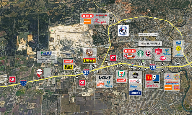
NEARBY LISTINGS FOR SALE OR LEASE
DEMOGRAPHICS near 0 Tbd
1 mile
3 mile
5 mile
2025 Total Population
3,205
14,768
75,428
2030 Population
3,648
16,939
85,935
Pop Growth 2025-2030
+ 13.82%
+ 14.70%
+ 13.93%
Average Age
35
36
37
2025 Total Households
1,084
5,019
26,290
HH Growth 2025-2030
+ 13.84%
+ 14.90%
+ 14.41%
Median Household Inc
$103,005
$98,101
$102,713
Avg Household Size
3.00
2.90
2.80
2025 Avg HH Vehicles
2.00
2.00
2.00
Median Home Value
$334,833
$360,357
$363,795
Median Year Built
2008
2010
2009
Nearby Places
Map Layers
Map Styles
 Street
 Aerial
Transit
 Traffic
 Biking
Places
Listings with unknown addresses are not visible on the map
- Restaurants
- Banks
- Shops
- Fitness
- Groceries
PUBLIC TRANSPORTATION
AIRPORT
San Antonio International
Drive
Walk
Distance
San Antonio International
25 min
20.9 mi
Freight Ports
Calhoun Port
Drive
Walk
Distance
Calhoun Port
179 min
152.5 mi
SALE & LEASE HISTORY
LISTING DATE
SALE/LEASE

Sep 24, 2016
For Sale
Sep 05, 2025
For Sale
Nov 07, 2022
For Sale
May 15, 2024
For Sale
Aug 03, 2017
For Sale
Apr 03, 2023
For Sale
Nearby Properties
Address
Land Use
TOTAL SIZE
Lot Size
Zoning
Address
Land Use
TOTAL SIZE
Lot Size
Zoning
361,563 SF
53.38 AC
Address
Land Use
TOTAL SIZE
Lot Size
Zoning
1.80 AC
Address
Land Use
TOTAL SIZE
Lot Size
Zoning
Address
Land Use
TOTAL SIZE
Lot Size
Zoning
94,020 SF
40.08 AC
Address
Land Use
TOTAL SIZE
Lot Size
Zoning
397,600 SF
25.95 AC
Address
Land Use
TOTAL SIZE
Lot Size
Zoning
102,000 SF
8.26 AC
Address
Land Use
TOTAL SIZE
Lot Size
Zoning
Address
Land Use
TOTAL SIZE
Lot Size
Zoning
52,898 SF
39.39 AC
Address
Land Use
TOTAL SIZE
Lot Size
Zoning
3,372 SF
76.62 AC
Address
Land Use
TOTAL SIZE
Lot Size
Zoning
969.31 AC
Address
Land Use
TOTAL SIZE
Lot Size
Zoning
141,551 SF
16 AC
Address
Land Use
TOTAL SIZE
Lot Size
Zoning
78,677 SF
21.12 AC
Address
Land Use
TOTAL SIZE
Lot Size
Zoning
89,104 SF
13.86 AC
Address
Land Use
TOTAL SIZE
Lot Size
Zoning
52,567 SF
10.32 AC
Address
Land Use
TOTAL SIZE
Lot Size
Zoning
524.42 AC
Address
Land Use
TOTAL SIZE
Lot Size
Zoning
10,523 SF
14.11 AC
Address
Land Use
TOTAL SIZE
Lot Size
Zoning
6,080 SF
3.86 AC
Address
Land Use
TOTAL SIZE
Lot Size
Zoning
1,308 SF
376.27 AC
Address
Land Use
TOTAL SIZE
Lot Size
Zoning
8,424 SF
13.50 AC
Address
Land Use
TOTAL SIZE
Lot Size
Zoning
44,533 SF
3.48 AC
Address
Land Use
TOTAL SIZE
Lot Size
Zoning
Address
Land Use
TOTAL SIZE
Lot Size
Zoning
40,358 SF
3.27 AC
Address
Land Use
TOTAL SIZE
Lot Size
Zoning
121,451 SF
7.33 AC
Address
Land Use
TOTAL SIZE
Lot Size
Zoning
410.44 AC
Address
Land Use
TOTAL SIZE
Lot Size
Zoning
16,276 SF
1.62 AC
Address
Land Use
TOTAL SIZE
Lot Size
Zoning
50,334 SF
17.38 AC
Address
Land Use
TOTAL SIZE
Lot Size
Zoning
160,783 SF
7.49 AC
Address
Land Use
TOTAL SIZE
Lot Size
Zoning
7,208 SF
6.06 AC
Address
Land Use
TOTAL SIZE
Lot Size
Zoning
2,912 SF
155.70 AC
Address
Land Use
TOTAL SIZE
Lot Size
Zoning
1,248 SF
53.66 AC
The World's #1 Commercial Real Estate Marketplace
Connect with us
© 2026 CoStar Group
The information above has been obtained from sources believed reliable. While we do not doubt its accuracy we have not verified it and make no guarantee, warranty or representation about it. It is your responsibility to independently confirm its accuracy and completeness. Any projections, opinions, assumptions, or estimates used are for example only and do not represent the current or future performance of the property. The value of this transaction to you depends on tax and other factors which should be evaluated by your tax, financial, and legal advisors. You and your advisors should conduct a careful, independent investigation of the property to determine to your satisfaction the suitability of the property for your needs.