Property Record
N Mcdonough Rd, Griffin, GA 30223

NEARBY LISTINGS FOR SALE OR LEASE
Property Detail
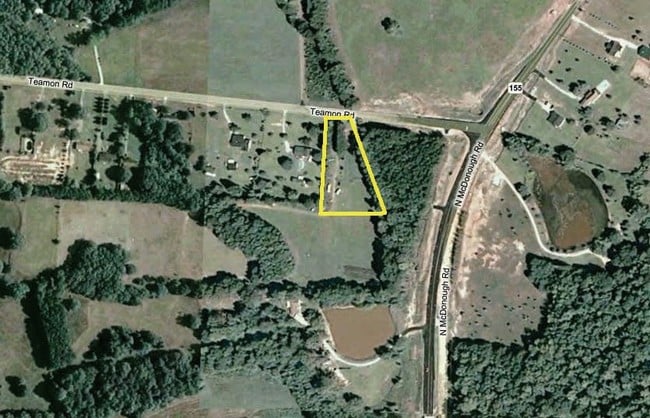
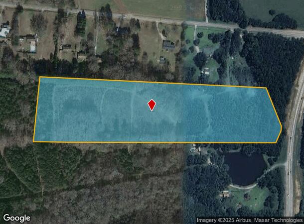
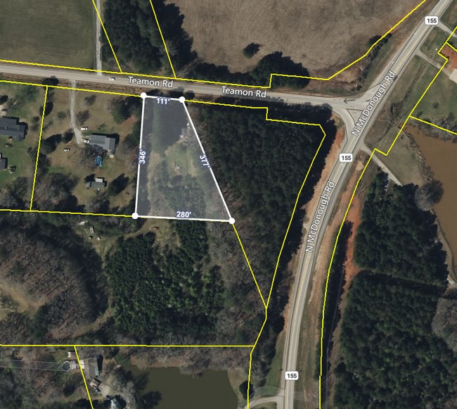
N Mcdonough Rd
201-01-026
13.224 AC PB 11/509
Agriculturalland
Spalding
X
Georgia
13255C0090E
13.22 AC
2024
Spalding County
2024
Atlanta
160402
Atlanta-Sandy Springs-Roswell, GA
DEMOGRAPHICS near N Mcdonough Rd
1 Mile
3 Mile
5 Mile
2024 Total Population
291
9,752
26,400
2029 Population
308
10,481
28,616
Pop Growth 2024-2029
+ 5.84%
+ 7.48%
+ 8.39%
Average Age
48
44
41
2024 Total Households
121
3,632
9,709
HH Growth 2024-2029
+ 5.79%
+ 7.21%
+ 8.21%
Median Household Inc
$71,249
$86,776
$74,634
Avg Household Size
2.40
2.60
2.70
2024 Avg HH Vehicles
2.00
2.00
2.00
Median Home Value
$247,727
$268,269
$240,574
Median Year Built
1997
2003
2003
Nearby Places
Map Layers
Map Styles
 Street
 Aerial
- Restaurants
- Banks
- Shops
- Fitness
- Groceries
PUBLIC TRANSPORTATION
AIRPORT
Hartsfield - Jackson Atlanta International
DRIVE
WALK
Distance
Hartsfield - Jackson Atlanta International
42 min
32.3 mi
Freight Ports
Georgia Ports - Savannah
DRIVE
WALK
Distance
Georgia Ports - Savannah
240 min
214.5 mi
SALE & LEASE HISTORY
LISTING DATE
SALE/LEASE

May 12, 2022
For Sale
Nearby Properties
Address
Land Use
TOTAL SIZE
Lot Size
Zoning
Address
Land Use
TOTAL SIZE
Lot Size
Zoning
6,720 SF
1,081.34 AC
Address
Land Use
TOTAL SIZE
Lot Size
Zoning
312 SF
258.57 AC
AAR
Address
Land Use
TOTAL SIZE
Lot Size
Zoning
16,698 SF
34.19 AC
AR1
Address
Land Use
TOTAL SIZE
Lot Size
Zoning
23.64 AC
R2
Address
Land Use
TOTAL SIZE
Lot Size
Zoning
279.69 AC
R1
Address
Land Use
TOTAL SIZE
Lot Size
Zoning
9,374 SF
168.36 AC
AAR
Address
Land Use
TOTAL SIZE
Lot Size
Zoning
92.40 AC
R2
Address
Land Use
TOTAL SIZE
Lot Size
Zoning
6,640 SF
2.93 AC
C1
Address
Land Use
TOTAL SIZE
Lot Size
Zoning
64.01 AC
PDD
Address
Land Use
TOTAL SIZE
Lot Size
Zoning
7,000 SF
2 AC
C1
Address
Land Use
TOTAL SIZE
Lot Size
Zoning
1,406 SF
183.89 AC
RA
Address
Land Use
TOTAL SIZE
Lot Size
Zoning
9,360 SF
2 AC
C-1
Address
Land Use
TOTAL SIZE
Lot Size
Zoning
16,817 SF
155.32 AC
C2
Address
Land Use
TOTAL SIZE
Lot Size
Zoning
5,040 SF
1.95 AC
C2
Address
Land Use
TOTAL SIZE
Lot Size
Zoning
4,790 SF
1.39 AC
C
Address
Land Use
TOTAL SIZE
Lot Size
Zoning
466.19 AC
R2/AR1
Address
Land Use
TOTAL SIZE
Lot Size
Zoning
10,733 SF
0.40 AC
C
Address
Land Use
TOTAL SIZE
Lot Size
Zoning
2.90 AC
AR1
Address
Land Use
TOTAL SIZE
Lot Size
Zoning
33,816 SF
3.50 AC
C3
Address
Land Use
TOTAL SIZE
Lot Size
Zoning
99.95 AC
R2
Address
Land Use
TOTAL SIZE
Lot Size
Zoning
167.93 AC
R2
Address
Land Use
TOTAL SIZE
Lot Size
Zoning
9,217 SF
1.46 AC
Address
Land Use
TOTAL SIZE
Lot Size
Zoning
600 SF
25.53 AC
R2/AR1
Address
Land Use
TOTAL SIZE
Lot Size
Zoning
2,328 SF
43.67 AC
AT
Address
Land Use
TOTAL SIZE
Lot Size
Zoning
200.93 AC
AR1
Address
Land Use
TOTAL SIZE
Lot Size
Zoning
2,760 SF
1.18 AC
C1
Address
Land Use
TOTAL SIZE
Lot Size
Zoning
3,150 SF
1.74 AC
R2
Address
Land Use
TOTAL SIZE
Lot Size
Zoning
153.27 AC
R2
The World's #1 Commercial Real Estate Marketplace
Connect with us
© 2025 CoStar Group
The information above has been obtained from sources believed reliable. While we do not doubt its accuracy we have not verified it and make no guarantee, warranty or representation about it. It is your responsibility to independently confirm its accuracy and completeness. Any projections, opinions, assumptions, or estimates used are for example only and do not represent the current or future performance of the property. The value of this transaction to you depends on tax and other factors which should be evaluated by your tax, financial, and legal advisors. You and your advisors should conduct a careful, independent investigation of the property to determine to your satisfaction the suitability of the property for your needs.