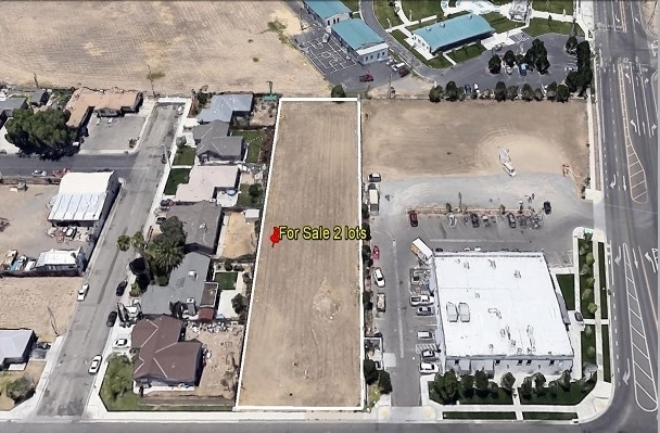
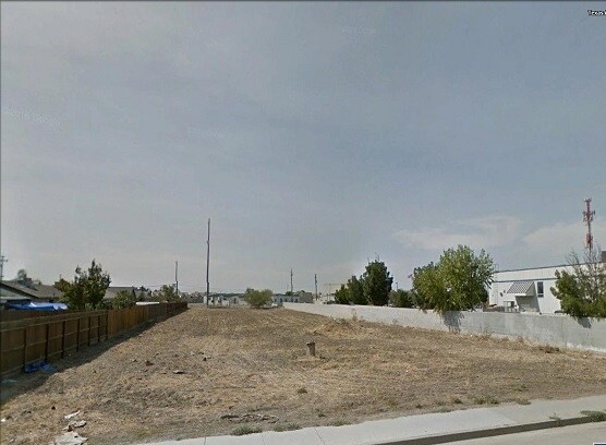
Property Record
110 W Madrone St, Los Banos, CA 93635

NEARBY LISTINGS FOR SALE OR LEASE
Property Detail
110 W Madrone St
Merced, CA
Cor Terrace
027-201-031
COR TER LOT 5
Recreationalacreage
Merced
X
California
06047C0850G
5
2024
0.29 AC
2025
Los Banos
002301
Fresno
DEMOGRAPHICS near 110 W Madrone St
1 Mile
3 Mile
5 Mile
2024 Total Population
11,936
51,067
52,895
2029 Population
12,876
55,356
57,310
Pop Growth 2024-2029
+ 7.88%
+ 8.40%
+ 8.35%
Average Age
35
35
35
2024 Total Households
3,433
14,194
14,706
HH Growth 2024-2029
+ 8.07%
+ 8.50%
+ 8.44%
Median Household Inc
$53,192
$64,438
$64,310
Avg Household Size
3.40
3.50
3.50
2024 Avg HH Vehicles
2.00
2.00
2.00
Median Home Value
$345,698
$369,567
$370,840
Median Year Built
1980
1993
1993
Nearby Places
- Restaurants
- Banks
- Shops
- Fitness
- Groceries
SALE & LEASE HISTORY
LISTING DATE
SALE/LEASE

Apr 11, 2017
For Sale
Nearby Properties
Address
Land Use
TOTAL SIZE
Lot Size
Zoning
Address
Land Use
TOTAL SIZE
Lot Size
Zoning
31.40 AC
A1
Address
Land Use
TOTAL SIZE
Lot Size
Zoning
7.16 AC
R3
Address
Land Use
TOTAL SIZE
Lot Size
Zoning
14.29 AC
HC
Address
Land Use
TOTAL SIZE
Lot Size
Zoning
4.93 AC
C2
Address
Land Use
TOTAL SIZE
Lot Size
Zoning
17.50 AC
HC
Address
Land Use
TOTAL SIZE
Lot Size
Zoning
5.80 AC
PF
Address
Land Use
TOTAL SIZE
Lot Size
Zoning
155,987 SF
10.12 AC
HC
Address
Land Use
TOTAL SIZE
Lot Size
Zoning
6.20 AC
A1
Address
Land Use
TOTAL SIZE
Lot Size
Zoning
13.30 AC
HC
Address
Land Use
TOTAL SIZE
Lot Size
Zoning
51,600 SF
3 AC
C2
Address
Land Use
TOTAL SIZE
Lot Size
Zoning
2,914 SF
77 AC
A2
Address
Land Use
TOTAL SIZE
Lot Size
Zoning
37,753 SF
3.46 AC
HC
Address
Land Use
TOTAL SIZE
Lot Size
Zoning
Address
Land Use
TOTAL SIZE
Lot Size
Zoning
4.22 AC
PD
Address
Land Use
TOTAL SIZE
Lot Size
Zoning
5.90 AC
R3
Address
Land Use
TOTAL SIZE
Lot Size
Zoning
12.40 AC
HC
Address
Land Use
TOTAL SIZE
Lot Size
Zoning
4,770 SF
4.78 AC
HC
Address
Land Use
TOTAL SIZE
Lot Size
Zoning
8,003 SF
5.17 AC
A1
Address
Land Use
TOTAL SIZE
Lot Size
Zoning
Address
Land Use
TOTAL SIZE
Lot Size
Zoning
21,080 SF
2.45 AC
Address
Land Use
TOTAL SIZE
Lot Size
Zoning
3,057 SF
2.60 AC
R3
Address
Land Use
TOTAL SIZE
Lot Size
Zoning
1.41 AC
HC
Address
Land Use
TOTAL SIZE
Lot Size
Zoning
Address
Land Use
TOTAL SIZE
Lot Size
Zoning
478.30 AC
A1
Address
Land Use
TOTAL SIZE
Lot Size
Zoning
13.40 AC
R1
Address
Land Use
TOTAL SIZE
Lot Size
Zoning
Address
Land Use
TOTAL SIZE
Lot Size
Zoning
The World's #1 Commercial Real Estate Marketplace
Connect with us
© 2025 CoStar Group
The information above has been obtained from sources believed reliable. While we do not doubt its accuracy we have not verified it and make no guarantee, warranty or representation about it. It is your responsibility to independently confirm its accuracy and completeness. Any projections, opinions, assumptions, or estimates used are for example only and do not represent the current or future performance of the property. The value of this transaction to you depends on tax and other factors which should be evaluated by your tax, financial, and legal advisors. You and your advisors should conduct a careful, independent investigation of the property to determine to your satisfaction the suitability of the property for your needs.