Property Record
0 Tracy Rd, Walbridge, OH 43465

Save to a Folder
{{folder.Name}}
{{folder.ListingIds.length}} Properties
{{folder.ListingIds.length}} Property
Create a New Folder
This Property Is For Sale
Property Detail
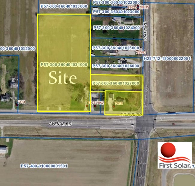
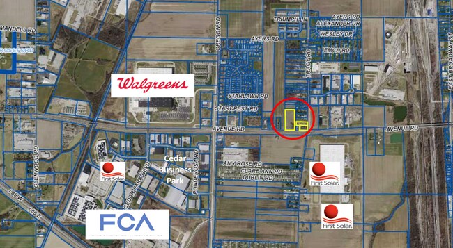
0 Tracy Rd
Toledo, OH
USR 03-36 N116.25 S256.29 E342.03SE SE
P57-300-360401027000
WOOD
Recreationalacreage
Ohio
B and X Area of moderate flood hazard, usually the area between the limits of the 100-year and 500-year floods.
0.93 AC
2025
Perrysburg/Northwood
2025
Toledo
020800
NEARBY LISTINGS FOR SALE OR LEASE
DEMOGRAPHICS near 0 Tracy Rd
1 mile
3 mile
5 mile
2025 Total Population
4,466
12,658
63,173
2030 Population
4,569
12,873
63,534
Pop Growth 2025-2030
+ 2.31%
+ 1.70%
+ 0.57%
Average Age
38
41
40
2025 Total Households
2,087
5,738
26,748
HH Growth 2025-2030
+ 2.06%
+ 1.66%
+ 0.55%
Median Household Inc
$59,981
$67,274
$66,249
Avg Household Size
2.10
2.10
2.30
2025 Avg HH Vehicles
2.00
2.00
2.00
Median Home Value
$139,338
$174,799
$177,802
Median Year Built
1998
1986
1969
Nearby Places
Map Layers
Map Styles
 Street
 Aerial
Layers
 Traffic
 Biking
Places
Listings with unknown addresses are not visible on the map
- Restaurants
- Banks
- Shops
- Fitness
- Groceries
PUBLIC TRANSPORTATION
COMMUTER RAIL
Toledo (Floridian - Amtrak, Lake Shore Limited - Amtrak)
Drive
Walk
Distance
Toledo (Floridian - Amtrak, Lake Shore Limited - Amtrak)
13 min
6.8 mi
AIRPORT
Eugene F Kranz Toledo Express
Drive
Walk
Distance
Eugene F Kranz Toledo Express
33 min
17.8 mi
Freight Ports
Port of Toledo
Drive
Walk
Distance
Port of Toledo
22 min
10.3 mi
Nearby Properties
Address
Land Use
TOTAL SIZE
Lot Size
Zoning
Address
Land Use
TOTAL SIZE
Lot Size
Zoning
288,140 SF
248.70 AC
Address
Land Use
TOTAL SIZE
Lot Size
Zoning
700,682 SF
100.30 AC
Address
Land Use
TOTAL SIZE
Lot Size
Zoning
1,445,856 SF
73.62 AC
Address
Land Use
TOTAL SIZE
Lot Size
Zoning
1,085,620 SF
76.95 AC
Address
Land Use
TOTAL SIZE
Lot Size
Zoning
505,362 SF
111.51 AC
Address
Land Use
TOTAL SIZE
Lot Size
Zoning
598,713 SF
59.75 AC
Address
Land Use
TOTAL SIZE
Lot Size
Zoning
1,607,895 SF
8 AC
Address
Land Use
TOTAL SIZE
Lot Size
Zoning
304,392 SF
17.38 AC
Address
Land Use
TOTAL SIZE
Lot Size
Zoning
788,541 SF
45.02 AC
Address
Land Use
TOTAL SIZE
Lot Size
Zoning
497,181 SF
50.37 AC
Address
Land Use
TOTAL SIZE
Lot Size
Zoning
261,715 SF
32.11 AC
Address
Land Use
TOTAL SIZE
Lot Size
Zoning
165,710 SF
21.61 AC
Address
Land Use
TOTAL SIZE
Lot Size
Zoning
211,020 SF
13.19 AC
Address
Land Use
TOTAL SIZE
Lot Size
Zoning
184,765 SF
12.91 AC
Address
Land Use
TOTAL SIZE
Lot Size
Zoning
486,615 SF
45.39 AC
Address
Land Use
TOTAL SIZE
Lot Size
Zoning
71,040 SF
34.93 AC
Address
Land Use
TOTAL SIZE
Lot Size
Zoning
661,200 SF
43.95 AC
Address
Land Use
TOTAL SIZE
Lot Size
Zoning
92,702 SF
4.61 AC
Address
Land Use
TOTAL SIZE
Lot Size
Zoning
2,135,540 SF
67.72 AC
Address
Land Use
TOTAL SIZE
Lot Size
Zoning
73,324 SF
16.80 AC
Address
Land Use
TOTAL SIZE
Lot Size
Zoning
392,037 SF
21.94 AC
Address
Land Use
TOTAL SIZE
Lot Size
Zoning
431,435 SF
13.74 AC
Address
Land Use
TOTAL SIZE
Lot Size
Zoning
170,760 SF
51.98 AC
Address
Land Use
TOTAL SIZE
Lot Size
Zoning
226,046 SF
17.15 AC
Address
Land Use
TOTAL SIZE
Lot Size
Zoning
372,803 SF
51.86 AC
Address
Land Use
TOTAL SIZE
Lot Size
Zoning
69,007 SF
15.93 AC
Address
Land Use
TOTAL SIZE
Lot Size
Zoning
75,770 SF
2.55 AC
Address
Land Use
TOTAL SIZE
Lot Size
Zoning
75,882 SF
19.08 AC
Address
Land Use
TOTAL SIZE
Lot Size
Zoning
46,528 SF
1.75 AC
Address
Land Use
TOTAL SIZE
Lot Size
Zoning
128,000 SF
9.37 AC
The World's #1 Commercial Real Estate Marketplace
Connect with us
© 2026 CoStar Group
The information above has been obtained from sources believed reliable. While we do not doubt its accuracy we have not verified it and make no guarantee, warranty or representation about it. It is your responsibility to independently confirm its accuracy and completeness. Any projections, opinions, assumptions, or estimates used are for example only and do not represent the current or future performance of the property. The value of this transaction to you depends on tax and other factors which should be evaluated by your tax, financial, and legal advisors. You and your advisors should conduct a careful, independent investigation of the property to determine to your satisfaction the suitability of the property for your needs.