Property Record
21612 Aldine Westfield Rd, Humble, TX 77338
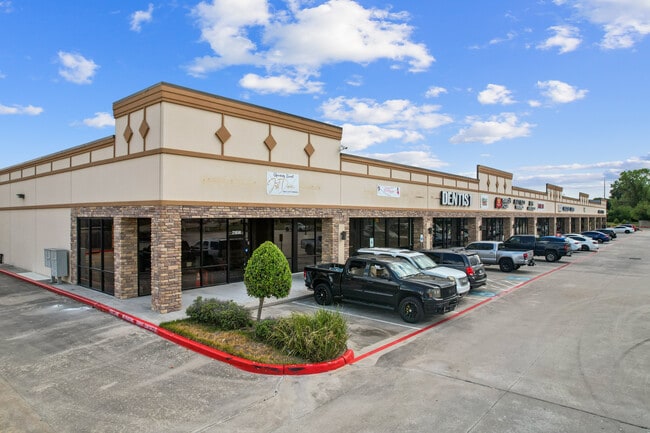

Property Detail
21612 Aldine Westfield Rd
1274730060067
RES B BLK 6 WERRINGTON SEC 1
Stripcommercialcenter
HARRIS
B and X Area of moderate flood hazard, usually the area between the limits of the 100-year and 500-year floods.
Texas
2025
4.30 AC
2025
Spring Creek
240802
Houston
25,200 SF
Houston-Pasadena-The Woodlands, TX
NEARBY LISTINGS FOR SALE OR LEASE
DEMOGRAPHICS near 21612 Aldine Westfield Rd
1 mile
3 mile
5 mile
2025 Total Population
9,900
84,270
209,643
2030 Population
10,652
90,403
225,728
Pop Growth 2025-2030
+ 7.60%
+ 7.28%
+ 7.67%
Average Age
33
35
35
2025 Total Households
3,130
27,220
70,256
HH Growth 2025-2030
+ 7.76%
+ 7.54%
+ 7.91%
Median Household Inc
$77,622
$77,352
$75,235
Avg Household Size
3.10
3.00
2.90
2025 Avg HH Vehicles
2.00
2.00
2.00
Median Home Value
$235,759
$231,857
$253,548
Median Year Built
2003
1995
1999
Nearby Places
Map Layers
Map Styles
 Street
 Aerial
Layers
 Traffic
 Biking
Places
Listings with unknown addresses are not visible on the map
- Restaurants
- Banks
- Shops
- Fitness
- Groceries
PUBLIC TRANSPORTATION
AIRPORT
George Bush Intcntl/Houston
Drive
Walk
Distance
George Bush Intcntl/Houston
16 min
9.5 mi
William P Hobby
Drive
Walk
Distance
William P Hobby
52 min
33.4 mi
Freight Ports
Port of Houston
Drive
Walk
Distance
Port of Houston
40 min
27.4 mi
SALE & LEASE HISTORY
LISTING DATE
SALE/LEASE

Sep 25, 2016
For Lease
Sep 19, 2022
For Sale
Oct 01, 2025
For Sale
Apr 18, 2023
For Lease
Nearby Properties
Address
Land Use
TOTAL SIZE
Lot Size
Zoning
Address
Land Use
TOTAL SIZE
Lot Size
Zoning
409,480 SF
27.32 AC
Address
Land Use
TOTAL SIZE
Lot Size
Zoning
350,423 SF
122.83 AC
Address
Land Use
TOTAL SIZE
Lot Size
Zoning
280,283 SF
16.56 AC
Address
Land Use
TOTAL SIZE
Lot Size
Zoning
271,432 SF
35.81 AC
Address
Land Use
TOTAL SIZE
Lot Size
Zoning
287,251 SF
18.12 AC
Address
Land Use
TOTAL SIZE
Lot Size
Zoning
259,000 SF
14.73 AC
Address
Land Use
TOTAL SIZE
Lot Size
Zoning
259,000 SF
15.73 AC
Address
Land Use
TOTAL SIZE
Lot Size
Zoning
357,485 SF
19.38 AC
Address
Land Use
TOTAL SIZE
Lot Size
Zoning
204,870 SF
13.40 AC
Address
Land Use
TOTAL SIZE
Lot Size
Zoning
203,013 SF
12.28 AC
Address
Land Use
TOTAL SIZE
Lot Size
Zoning
238,835 SF
9.98 AC
Address
Land Use
TOTAL SIZE
Lot Size
Zoning
249,296 SF
10.10 AC
Address
Land Use
TOTAL SIZE
Lot Size
Zoning
175,495 SF
8.92 AC
Address
Land Use
TOTAL SIZE
Lot Size
Zoning
267,250 SF
11.83 AC
Address
Land Use
TOTAL SIZE
Lot Size
Zoning
127,260 SF
14 AC
Address
Land Use
TOTAL SIZE
Lot Size
Zoning
222,382 SF
10.44 AC
Address
Land Use
TOTAL SIZE
Lot Size
Zoning
159,514 SF
11.40 AC
Address
Land Use
TOTAL SIZE
Lot Size
Zoning
110,597 SF
9.06 AC
Address
Land Use
TOTAL SIZE
Lot Size
Zoning
132,102 SF
14.93 AC
Address
Land Use
TOTAL SIZE
Lot Size
Zoning
99,561 SF
11.60 AC
Address
Land Use
TOTAL SIZE
Lot Size
Zoning
101,399 SF
17.11 AC
Address
Land Use
TOTAL SIZE
Lot Size
Zoning
125,674 SF
11.56 AC
Address
Land Use
TOTAL SIZE
Lot Size
Zoning
216,390 SF
8.42 AC
Address
Land Use
TOTAL SIZE
Lot Size
Zoning
281,563 SF
19.98 AC
Address
Land Use
TOTAL SIZE
Lot Size
Zoning
186,971 SF
7.58 AC
Address
Land Use
TOTAL SIZE
Lot Size
Zoning
152,440 SF
24.67 AC
Address
Land Use
TOTAL SIZE
Lot Size
Zoning
89,044 SF
13.17 AC
Address
Land Use
TOTAL SIZE
Lot Size
Zoning
288,503 SF
14.57 AC
Address
Land Use
TOTAL SIZE
Lot Size
Zoning
64,010 SF
5.90 AC
Address
Land Use
TOTAL SIZE
Lot Size
Zoning
171,018 SF
6.35 AC
The World's #1 Commercial Real Estate Marketplace
Connect with us
© 2026 CoStar Group
The information above has been obtained from sources believed reliable. While we do not doubt its accuracy we have not verified it and make no guarantee, warranty or representation about it. It is your responsibility to independently confirm its accuracy and completeness. Any projections, opinions, assumptions, or estimates used are for example only and do not represent the current or future performance of the property. The value of this transaction to you depends on tax and other factors which should be evaluated by your tax, financial, and legal advisors. You and your advisors should conduct a careful, independent investigation of the property to determine to your satisfaction the suitability of the property for your needs.