Property Record
0 Trillium Cir, Acton, MA 01720
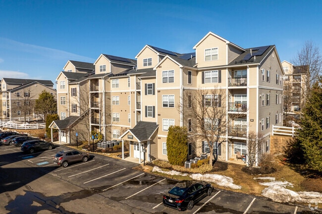

Property Detail
0 Trillium Cir
ACTO-000005B-000009
MIDDLESEX
Multifamilydwelling
Massachusetts
R108
14.47 AC
B and X Area of moderate flood hazard, usually the area between the limits of the 100-year and 500-year floods.
Acton
2025
Boston
2025
Boston-Cambridge-Newton, MA-NH
363103
NEARBY LISTINGS FOR SALE OR LEASE
-
-
View all Acton listings for sale on LoopNet.com
DEMOGRAPHICS near 0 Trillium Cir
1 mile
3 mile
5 mile
2025 Total Population
4,074
21,852
63,969
2030 Population
4,297
22,944
66,719
Pop Growth 2025-2030
+ 5.47%
+ 5.00%
+ 4.30%
Average Age
41
42
42
2025 Total Households
1,573
8,167
23,585
HH Growth 2025-2030
+ 5.59%
+ 5.11%
+ 4.46%
Median Household Inc
$121,086
$149,484
$169,451
Avg Household Size
2.50
2.60
2.70
2025 Avg HH Vehicles
2.00
2.00
2.00
Median Home Value
$700,617
$778,481
$773,408
Median Year Built
1996
1984
1978
Nearby Places
Map Layers
Map Styles
 Street
 Aerial
Layers
 Traffic
 Biking
Places
Listings with unknown addresses are not visible on the map
- Restaurants
- Banks
- Shops
- Fitness
- Groceries
PUBLIC TRANSPORTATION
COMMUTER RAIL
Littleton/Route 495 (Fitchburg/South Acton Line - Massachusetts Bay Transportation Authority Commuter Rail (Purple Line))
Drive
Walk
Distance
Littleton/Route 495 (Fitchburg/South Acton Line - Massachusetts Bay Transportation Authority Commuter Rail (Purple Line))
14 min
6.3 mi
South Acton (Fitchburg/South Acton Line - Massachusetts Bay Transportation Authority Commuter Rail (Purple Line))
Drive
Walk
Distance
South Acton (Fitchburg/South Acton Line - Massachusetts Bay Transportation Authority Commuter Rail (Purple Line))
16 min
6.6 mi
AIRPORT
General Edward Lawrence Logan International
Drive
Walk
Distance
General Edward Lawrence Logan International
50 min
29.7 mi
Manchester Boston Regional
Drive
Walk
Distance
Manchester Boston Regional
59 min
35.7 mi
Worcester Regional
Drive
Walk
Distance
Worcester Regional
56 min
38.0 mi
Freight Ports
Port of Boston
Drive
Walk
Distance
Port of Boston
50 min
29.7 mi
Nearby Properties
Address
Land Use
TOTAL SIZE
Lot Size
Zoning
Address
Land Use
TOTAL SIZE
Lot Size
Zoning
310,328 SF
22.24 AC
IH
Address
Land Use
TOTAL SIZE
Lot Size
Zoning
236,297 SF
17.62 AC
CH
Address
Land Use
TOTAL SIZE
Lot Size
Zoning
8.39 AC
OP1
Address
Land Use
TOTAL SIZE
Lot Size
Zoning
220,257 SF
24.17 AC
CH
Address
Land Use
TOTAL SIZE
Lot Size
Zoning
7.32 AC
R
Address
Land Use
TOTAL SIZE
Lot Size
Zoning
161,850 SF
18.41 AC
CH
Address
Land Use
TOTAL SIZE
Lot Size
Zoning
291,926 SF
31.78 AC
IH
Address
Land Use
TOTAL SIZE
Lot Size
Zoning
9.96 AC
OP1
Address
Land Use
TOTAL SIZE
Lot Size
Zoning
79,254 SF
18.14 AC
RA
Address
Land Use
TOTAL SIZE
Lot Size
Zoning
155,922 SF
14.61 AC
CH
Address
Land Use
TOTAL SIZE
Lot Size
Zoning
396,023 SF
23.53 AC
OP1
Address
Land Use
TOTAL SIZE
Lot Size
Zoning
171,494 SF
15.68 AC
CH
Address
Land Use
TOTAL SIZE
Lot Size
Zoning
39,250 SF
0.39 AC
R2
Address
Land Use
TOTAL SIZE
Lot Size
Zoning
87,430 SF
9.30 AC
CH
Address
Land Use
TOTAL SIZE
Lot Size
Zoning
130,524 SF
19.74 AC
IH
Address
Land Use
TOTAL SIZE
Lot Size
Zoning
66,447 SF
11.59 AC
B
Address
Land Use
TOTAL SIZE
Lot Size
Zoning
175,718 SF
20.12 AC
IH
Address
Land Use
TOTAL SIZE
Lot Size
Zoning
38,552 SF
5.34 AC
LB
Address
Land Use
TOTAL SIZE
Lot Size
Zoning
57,700 SF
8.27 AC
CH
Address
Land Use
TOTAL SIZE
Lot Size
Zoning
78,564 SF
3.43 AC
LB
Address
Land Use
TOTAL SIZE
Lot Size
Zoning
119,000 SF
11.19 AC
OP1
Address
Land Use
TOTAL SIZE
Lot Size
Zoning
78,722 SF
7.54 AC
LB
Address
Land Use
TOTAL SIZE
Lot Size
Zoning
3.85 AC
RA
Address
Land Use
TOTAL SIZE
Lot Size
Zoning
60,850 SF
31.75 AC
R
Address
Land Use
TOTAL SIZE
Lot Size
Zoning
80,974 SF
14.36 AC
CH
Address
Land Use
TOTAL SIZE
Lot Size
Zoning
44,586 SF
8.28 AC
CH
Address
Land Use
TOTAL SIZE
Lot Size
Zoning
14,856 SF
136.91 AC
CH
Address
Land Use
TOTAL SIZE
Lot Size
Zoning
66,515 SF
23.98 AC
SM
Address
Land Use
TOTAL SIZE
Lot Size
Zoning
4.49 AC
SM
The World's #1 Commercial Real Estate Marketplace
Connect with us
© 2026 CoStar Group
The information above has been obtained from sources believed reliable. While we do not doubt its accuracy we have not verified it and make no guarantee, warranty or representation about it. It is your responsibility to independently confirm its accuracy and completeness. Any projections, opinions, assumptions, or estimates used are for example only and do not represent the current or future performance of the property. The value of this transaction to you depends on tax and other factors which should be evaluated by your tax, financial, and legal advisors. You and your advisors should conduct a careful, independent investigation of the property to determine to your satisfaction the suitability of the property for your needs.