Property Record
312 Lee Rd, Smiths Station, AL 36877

NEARBY LISTINGS FOR SALE OR LEASE
Property Detail
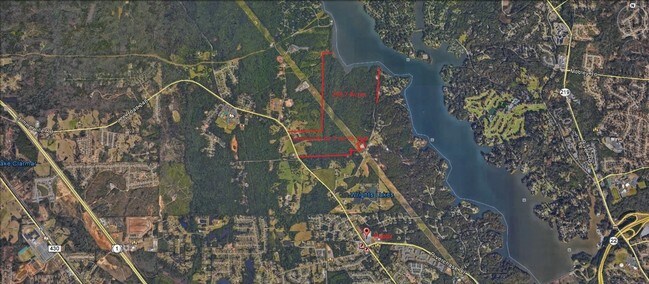
312 Lee Rd
Auburn-Opelika, AL
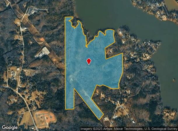
Boundary Survey
14-05-21-0-000-001.000
TRACT 301A A PROPERTY BOUNDARY SURVEY FOR THE ADMINISTRATIVE S/D OF LOT 1C OF THE DIVISION OF PARCEL 100 & LOT 100A OF THE WA
Timberlandforesttreesagricultural
Lee
AE
Alabama
1351580021G
100a
2025
169.82 AC
2025
Lee County
042006
Columbus GA
DEMOGRAPHICS near 312 Lee Rd
1 Mile
3 Mile
5 Mile
2024 Total Population
744
19,663
76,968
2029 Population
771
20,286
77,757
Pop Growth 2024-2029
+ 3.63%
+ 3.17%
+ 1.03%
Average Age
45
43
39
2024 Total Households
311
7,998
31,068
HH Growth 2024-2029
+ 3.22%
+ 2.96%
+ 0.84%
Median Household Inc
$84,191
$74,897
$54,825
Avg Household Size
2.40
2.40
2.40
2024 Avg HH Vehicles
2.00
2.00
2.00
Median Home Value
$396,666
$258,953
$176,344
Median Year Built
1994
1993
1982
Nearby Places
- Restaurants
- Banks
- Shops
- Fitness
- Groceries
PUBLIC TRANSPORTATION
AIRPORT
Columbus
DRIVE
WALK
Distance
Columbus
19 min
9.1 mi
Freight Ports
Port of Panama City
DRIVE
WALK
Distance
Port of Panama City
242 min
188.5 mi
SALE & LEASE HISTORY
LISTING DATE
SALE/LEASE

Sep 24, 2016
For Sale
Oct 18, 2016
For Sale
Oct 18, 2016
For Sale
Oct 14, 2016
For Sale
May 05, 2017
For Sale
Mar 31, 2017
For Sale
Nearby Properties
Address
Land Use
TOTAL SIZE
Lot Size
Zoning
Address
Land Use
TOTAL SIZE
Lot Size
Zoning
2,744 SF
2.04 AC
Address
Land Use
TOTAL SIZE
Lot Size
Zoning
2,744 SF
41.16 AC
Address
Land Use
TOTAL SIZE
Lot Size
Zoning
11,230 SF
25.05 AC
Address
Land Use
TOTAL SIZE
Lot Size
Zoning
9,266 SF
50.07 AC
Address
Land Use
TOTAL SIZE
Lot Size
Zoning
64,793 SF
34.48 AC
Address
Land Use
TOTAL SIZE
Lot Size
Zoning
68,645 SF
9.99 AC
Address
Land Use
TOTAL SIZE
Lot Size
Zoning
24.20 AC
Address
Land Use
TOTAL SIZE
Lot Size
Zoning
3,970 SF
9.05 AC
Address
Land Use
TOTAL SIZE
Lot Size
Zoning
11,644 SF
6.57 AC
Address
Land Use
TOTAL SIZE
Lot Size
Zoning
21,584 SF
28.11 AC
Address
Land Use
TOTAL SIZE
Lot Size
Zoning
23,488 SF
26 AC
Address
Land Use
TOTAL SIZE
Lot Size
Zoning
6,667 SF
17.84 AC
Address
Land Use
TOTAL SIZE
Lot Size
Zoning
43.53 AC
Address
Land Use
TOTAL SIZE
Lot Size
Zoning
54,175 SF
6 AC
Address
Land Use
TOTAL SIZE
Lot Size
Zoning
27.84 AC
Address
Land Use
TOTAL SIZE
Lot Size
Zoning
6,645 SF
9.41 AC
Address
Land Use
TOTAL SIZE
Lot Size
Zoning
18,523 SF
138.08 AC
Address
Land Use
TOTAL SIZE
Lot Size
Zoning
43,056 SF
4 AC
O
Address
Land Use
TOTAL SIZE
Lot Size
Zoning
57,826 SF
7 AC
O
Address
Land Use
TOTAL SIZE
Lot Size
Zoning
Address
Land Use
TOTAL SIZE
Lot Size
Zoning
1,029 SF
11.08 AC
Address
Land Use
TOTAL SIZE
Lot Size
Zoning
Address
Land Use
TOTAL SIZE
Lot Size
Zoning
3,420 SF
16 AC
O
Address
Land Use
TOTAL SIZE
Lot Size
Zoning
11,124 SF
5 AC
Address
Land Use
TOTAL SIZE
Lot Size
Zoning
13,683 SF
4.40 AC
Address
Land Use
TOTAL SIZE
Lot Size
Zoning
58,094 SF
8.27 AC
Address
Land Use
TOTAL SIZE
Lot Size
Zoning
3,776 SF
5.30 AC
Address
Land Use
TOTAL SIZE
Lot Size
Zoning
1,408 SF
11.95 AC
Address
Land Use
TOTAL SIZE
Lot Size
Zoning
104,950 SF
6 AC
C
The World's #1 Commercial Real Estate Marketplace
Connect with us
© 2025 CoStar Group
The information above has been obtained from sources believed reliable. While we do not doubt its accuracy we have not verified it and make no guarantee, warranty or representation about it. It is your responsibility to independently confirm its accuracy and completeness. Any projections, opinions, assumptions, or estimates used are for example only and do not represent the current or future performance of the property. The value of this transaction to you depends on tax and other factors which should be evaluated by your tax, financial, and legal advisors. You and your advisors should conduct a careful, independent investigation of the property to determine to your satisfaction the suitability of the property for your needs.