Property Record
0 Unassigned, Stuart, FL 34997


Save to a Folder
{{folder.Name}}
{{folder.ListingIds.length}} Properties
{{folder.ListingIds.length}} Property
Create a New Folder
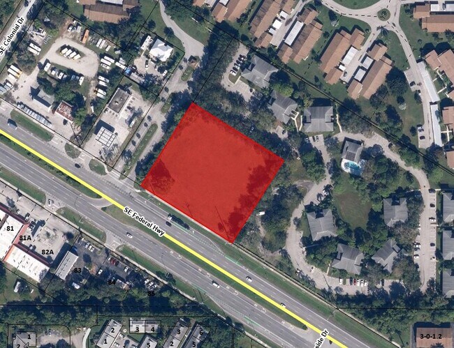
Property Detail
0 Unassigned
Port St. Lucie, FL
PART OF NE 1/4 OF SEC 36 T38S R41E AS FOLLOWS: BEG AT SE COR W 405.87 M/L TO NE R/W US 1 NW ALG US 1 338.72 TO POB CONT NW 305 NE 275 SE 305 & SW 275 TO POB
36-38-41-000-000-00044-6
MARTIN
Commercialacreage
Florida
COR2
4
B and X Area of moderate flood hazard, usually the area between the limits of the 100-year and 500-year floods.
1.93 AC
2024
Martin
2025
Port St Lucie/Fort Pierce
001107
NEARBY LISTINGS FOR SALE OR LEASE
DEMOGRAPHICS near 0 Unassigned
1 mile
3 mile
5 mile
2025 Total Population
7,935
34,173
66,601
2030 Population
8,186
35,401
69,092
Pop Growth 2025-2030
+ 3.16%
+ 3.59%
+ 3.74%
Average Age
49
52
50
2025 Total Households
3,562
15,827
29,922
HH Growth 2025-2030
+ 3.17%
+ 3.49%
+ 3.72%
Median Household Inc
$71,375
$69,574
$68,352
Avg Household Size
2.10
2.10
2.10
2025 Avg HH Vehicles
2.00
2.00
2.00
Median Home Value
$368,488
$388,930
$399,855
Median Year Built
1988
1986
1985
Nearby Places
Map Layers
Map Styles
 Street
 Aerial
Layers
 Traffic
 Biking
Places
Listings with unknown addresses are not visible on the map
- Restaurants
- Banks
- Shops
- Fitness
- Groceries
SALE & LEASE HISTORY
LISTING DATE
SALE/LEASE

Jul 08, 2023
For Sale
Nearby Properties
Address
Land Use
TOTAL SIZE
Lot Size
Zoning
Address
Land Use
TOTAL SIZE
Lot Size
Zoning
13.62 AC
R2
Address
Land Use
TOTAL SIZE
Lot Size
Zoning
118,989 SF
12.43 AC
PUDC
Address
Land Use
TOTAL SIZE
Lot Size
Zoning
126,304 SF
36 AC
R2
Address
Land Use
TOTAL SIZE
Lot Size
Zoning
45,029 SF
11.80 AC
PUDC
Address
Land Use
TOTAL SIZE
Lot Size
Zoning
136,749 SF
14.90 AC
GC
Address
Land Use
TOTAL SIZE
Lot Size
Zoning
212,454 SF
33.77 AC
CPUD
Address
Land Use
TOTAL SIZE
Lot Size
Zoning
48,450 SF
7.94 AC
Address
Land Use
TOTAL SIZE
Lot Size
Zoning
30,423 SF
13.74 AC
WGC
Address
Land Use
TOTAL SIZE
Lot Size
Zoning
59,023 SF
12.31 AC
Address
Land Use
TOTAL SIZE
Lot Size
Zoning
106,719 SF
4.94 AC
Address
Land Use
TOTAL SIZE
Lot Size
Zoning
106,105 SF
7.41 AC
PUDR
Address
Land Use
TOTAL SIZE
Lot Size
Zoning
102,843 SF
9.03 AC
Address
Land Use
TOTAL SIZE
Lot Size
Zoning
153,260 SF
13.50 AC
PS
Address
Land Use
TOTAL SIZE
Lot Size
Zoning
105,716 SF
10.13 AC
R5
Address
Land Use
TOTAL SIZE
Lot Size
Zoning
50,773 SF
9.40 AC
COR2
Address
Land Use
TOTAL SIZE
Lot Size
Zoning
131,383 SF
8.80 AC
R3A
Address
Land Use
TOTAL SIZE
Lot Size
Zoning
63,133 SF
19.65 AC
A1
Address
Land Use
TOTAL SIZE
Lot Size
Zoning
83,348 SF
8.12 AC
PUDR
Address
Land Use
TOTAL SIZE
Lot Size
Zoning
78,591 SF
19.97 AC
PUDR
Address
Land Use
TOTAL SIZE
Lot Size
Zoning
56,665 SF
10 AC
CPUD
Address
Land Use
TOTAL SIZE
Lot Size
Zoning
102,130 SF
4.06 AC
R3A
Address
Land Use
TOTAL SIZE
Lot Size
Zoning
63,874 SF
4.39 AC
PUDC
Address
Land Use
TOTAL SIZE
Lot Size
Zoning
97,017 SF
4.60 AC
GC
Address
Land Use
TOTAL SIZE
Lot Size
Zoning
37,429 SF
15.74 AC
GC
Address
Land Use
TOTAL SIZE
Lot Size
Zoning
161,868 SF
19.20 AC
PS
Address
Land Use
TOTAL SIZE
Lot Size
Zoning
19.03 AC
CPUD
Address
Land Use
TOTAL SIZE
Lot Size
Zoning
125,339 SF
23.95 AC
PUDR
Address
Land Use
TOTAL SIZE
Lot Size
Zoning
79,390 SF
12.31 AC
GC
Address
Land Use
TOTAL SIZE
Lot Size
Zoning
48,957 SF
6.63 AC
CPUD
Address
Land Use
TOTAL SIZE
Lot Size
Zoning
32,763 SF
5.83 AC
CPUD
The World's #1 Commercial Real Estate Marketplace
Connect with us
© 2026 CoStar Group
The information above has been obtained from sources believed reliable. While we do not doubt its accuracy we have not verified it and make no guarantee, warranty or representation about it. It is your responsibility to independently confirm its accuracy and completeness. Any projections, opinions, assumptions, or estimates used are for example only and do not represent the current or future performance of the property. The value of this transaction to you depends on tax and other factors which should be evaluated by your tax, financial, and legal advisors. You and your advisors should conduct a careful, independent investigation of the property to determine to your satisfaction the suitability of the property for your needs.