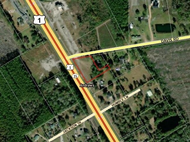
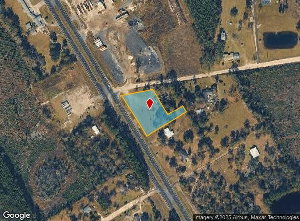
Property Record
Us Highway 1, Hilliard, FL 32046
This Property Is For Sale
NEARBY LISTINGS FOR SALE OR LEASE
Property Detail
Us Highway 1
Jacksonville, FL
St Marys Heights Sub
30-4N-24-2740-0014-0020
W200 FT OF LOT 14 & N50 FT OF LOT 15 ST MARYS HEIGHTS SUB PB 3/36
Vacantlandnec
Nassau
X
Florida
12089C0130F
14
2025
0.13 AC
2025
Nassau County
050403
Jacksonville (Florida)
DEMOGRAPHICS near Us Highway 1
1 Mile
3 Mile
5 Mile
2024 Total Population
252
2,152
7,218
2029 Population
345
2,948
9,860
Pop Growth 2024-2029
+ 36.90%
+ 36.99%
+ 36.60%
Average Age
41
41
40
2024 Total Households
92
790
2,646
HH Growth 2024-2029
+ 36.96%
+ 37.34%
+ 36.89%
Median Household Inc
$65,000
$68,516
$68,032
Avg Household Size
2.70
2.70
2.70
2024 Avg HH Vehicles
2.00
2.00
2.00
Median Home Value
$328,571
$278,321
$274,111
Median Year Built
1994
1995
1993
Nearby Places
Map Layers
Map Styles
 Street
 Aerial
- Restaurants
- Banks
- Shops
- Fitness
- Groceries
PUBLIC TRANSPORTATION
AIRPORT
Jacksonville International
DRIVE
WALK
Distance
Jacksonville International
44 min
29.1 mi
Freight Ports
Jacksonville Port
DRIVE
WALK
Distance
Jacksonville Port
53 min
36.0 mi
Nearby Properties
Address
Land Use
TOTAL SIZE
Lot Size
Zoning
Address
Land Use
TOTAL SIZE
Lot Size
Zoning
42,825 SF
4 AC
OR
Address
Land Use
TOTAL SIZE
Lot Size
Zoning
23,621 SF
35.49 AC
OR
Address
Land Use
TOTAL SIZE
Lot Size
Zoning
9,844 SF
6.50 AC
A-1
Address
Land Use
TOTAL SIZE
Lot Size
Zoning
11,556 SF
1.30 AC
R-3
Address
Land Use
TOTAL SIZE
Lot Size
Zoning
9,730 SF
79.13 AC
OR
Address
Land Use
TOTAL SIZE
Lot Size
Zoning
14,189 SF
92.20 AC
OR
Address
Land Use
TOTAL SIZE
Lot Size
Zoning
7,172 SF
5.80 AC
OR
Address
Land Use
TOTAL SIZE
Lot Size
Zoning
4,139 SF
4.42 AC
CI
Address
Land Use
TOTAL SIZE
Lot Size
Zoning
11,354 SF
2.47 AC
CI
Address
Land Use
TOTAL SIZE
Lot Size
Zoning
17,120 SF
3.09 AC
C-1 - HILL
Address
Land Use
TOTAL SIZE
Lot Size
Zoning
3,536 SF
52.82 AC
OR
Address
Land Use
TOTAL SIZE
Lot Size
Zoning
10,548 SF
1.55 AC
C-1 - HILL
Address
Land Use
TOTAL SIZE
Lot Size
Zoning
15,520 SF
5.94 AC
CI
Address
Land Use
TOTAL SIZE
Lot Size
Zoning
3,834 SF
14.39 AC
OR
Address
Land Use
TOTAL SIZE
Lot Size
Zoning
5,174 SF
2.83 AC
CI
Address
Land Use
TOTAL SIZE
Lot Size
Zoning
181 AC
OR
Address
Land Use
TOTAL SIZE
Lot Size
Zoning
5,895 SF
16.69 AC
OR
Address
Land Use
TOTAL SIZE
Lot Size
Zoning
24,255 SF
14 AC
OR
Address
Land Use
TOTAL SIZE
Lot Size
Zoning
7,339 SF
32.66 AC
OR
Address
Land Use
TOTAL SIZE
Lot Size
Zoning
5,174 SF
1.92 AC
OR
Address
Land Use
TOTAL SIZE
Lot Size
Zoning
4,695 SF
0.32 AC
C-1 - HILL
Address
Land Use
TOTAL SIZE
Lot Size
Zoning
6,000 SF
1.60 AC
C-1 - HILL
Address
Land Use
TOTAL SIZE
Lot Size
Zoning
3,915 SF
28 AC
OR
Address
Land Use
TOTAL SIZE
Lot Size
Zoning
2,190 SF
20.50 AC
OR
Address
Land Use
TOTAL SIZE
Lot Size
Zoning
3,072 SF
30.77 AC
OR
Address
Land Use
TOTAL SIZE
Lot Size
Zoning
132.87 AC
OR
Address
Land Use
TOTAL SIZE
Lot Size
Zoning
4,358 SF
10.12 AC
OR
Address
Land Use
TOTAL SIZE
Lot Size
Zoning
1,334 SF
9 AC
CG
Address
Land Use
TOTAL SIZE
Lot Size
Zoning
5,724 SF
1.93 AC
CG
Address
Land Use
TOTAL SIZE
Lot Size
Zoning
3,778 SF
10.10 AC
OR
The World's #1 Commercial Real Estate Marketplace
Connect with us
© 2026 CoStar Group
The information above has been obtained from sources believed reliable. While we do not doubt its accuracy we have not verified it and make no guarantee, warranty or representation about it. It is your responsibility to independently confirm its accuracy and completeness. Any projections, opinions, assumptions, or estimates used are for example only and do not represent the current or future performance of the property. The value of this transaction to you depends on tax and other factors which should be evaluated by your tax, financial, and legal advisors. You and your advisors should conduct a careful, independent investigation of the property to determine to your satisfaction the suitability of the property for your needs.