Property Record
E Irlo Bronson Memorial Hwy, Kissimmee, FL 34744
NEARBY LISTINGS FOR SALE OR LEASE
Property Detail
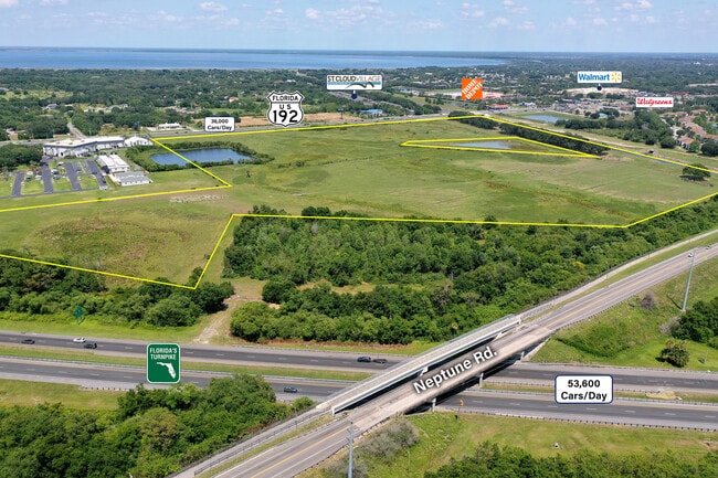
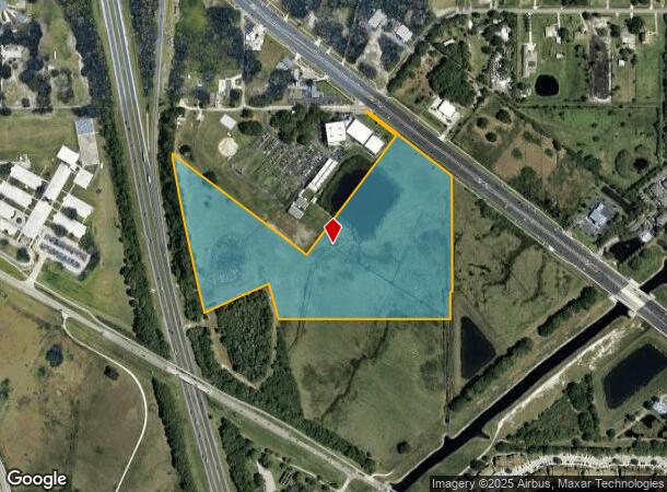
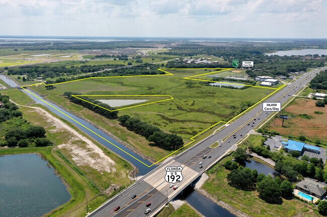
E Irlo Bronson Memorial Hwy
Orlando-Kissimmee-Sanford, FL
Florida Drainland Co
26-25-29-3140-0033-0010
FLA DRAINLAND CO SUB 1 PB B PG 65 BLK 33 LOTS 1-6, S OF HWY 441 LESS THAT PART OF LOTS 5 & 6 LYING WITHIN SUNSHINE ST PARKWAY R/W & LESS COM AT NE COR OF SEC, W 575 FT, S 53 DEG E 33.08 FT TO POB; W 1021.40 FT, S 53 DEG E 889.99 FT, N 37 DEG E 417.42
Countyproperty
Osceola
X
Florida
12095C0650G
1
2024
28.88 AC
2025
St Cloud
042701
Orlando
DEMOGRAPHICS near E Irlo Bronson Memorial Hwy
1 Mile
3 Mile
5 Mile
2024 Total Population
4,326
46,765
98,282
2029 Population
5,135
55,788
117,219
Pop Growth 2024-2029
+ 18.70%
+ 19.29%
+ 19.27%
Average Age
36
38
38
2024 Total Households
1,376
16,202
32,989
HH Growth 2024-2029
+ 18.53%
+ 19.19%
+ 19.12%
Median Household Inc
$46,148
$54,093
$59,712
Avg Household Size
3.10
2.80
2.90
2024 Avg HH Vehicles
2.00
2.00
2.00
Median Home Value
$309,786
$275,197
$275,753
Median Year Built
2000
2001
1999
Nearby Places
Map Layers
Map Styles
 Street
 Aerial
- Restaurants
- Banks
- Shops
- Fitness
- Groceries
PUBLIC TRANSPORTATION
COMMUTER RAIL
Kissimmee Amtrak Station (Silver Meteor - Amtrak, Silver Star - Amtrak, SunRail - Amtrak)
DRIVE
WALK
Distance
Kissimmee Amtrak Station (Silver Meteor - Amtrak, Silver Star - Amtrak, SunRail - Amtrak)
13 min
6.4 mi
Tupperware (SunRail - Florida Department of Transportation)
DRIVE
WALK
Distance
Tupperware (SunRail - Florida Department of Transportation)
14 min
8.6 mi
AIRPORT
Orlando International
DRIVE
WALK
Distance
Orlando International
27 min
15.9 mi
Freight Ports
Port Canaveral
DRIVE
WALK
Distance
Port Canaveral
75 min
57.6 mi
SALE & LEASE HISTORY
LISTING DATE
SALE/LEASE

Jun 23, 2021
For Sale
Nearby Properties
Address
Land Use
TOTAL SIZE
Lot Size
Zoning
Address
Land Use
TOTAL SIZE
Lot Size
Zoning
457,374 SF
30.93 AC
OCT
Address
Land Use
TOTAL SIZE
Lot Size
Zoning
402,010 SF
22.33 AC
OCR
Address
Land Use
TOTAL SIZE
Lot Size
Zoning
343,107 SF
16.26 AC
OEC
Address
Land Use
TOTAL SIZE
Lot Size
Zoning
270,959 SF
10.84 AC
SPUD
Address
Land Use
TOTAL SIZE
Lot Size
Zoning
275,507 SF
22.19 AC
RM-2
Address
Land Use
TOTAL SIZE
Lot Size
Zoning
437,037 SF
34.76 AC
OPUD
Address
Land Use
TOTAL SIZE
Lot Size
Zoning
188,719 SF
10.81 AC
Address
Land Use
TOTAL SIZE
Lot Size
Zoning
203,711 SF
10.27 AC
Address
Land Use
TOTAL SIZE
Lot Size
Zoning
187,302 SF
20.85 AC
Address
Land Use
TOTAL SIZE
Lot Size
Zoning
145,028 SF
6.85 AC
Address
Land Use
TOTAL SIZE
Lot Size
Zoning
309,075 SF
16.94 AC
OPUD
Address
Land Use
TOTAL SIZE
Lot Size
Zoning
304,494 SF
15.67 AC
Address
Land Use
TOTAL SIZE
Lot Size
Zoning
118,121 SF
237.16 AC
SP
Address
Land Use
TOTAL SIZE
Lot Size
Zoning
208,677 SF
12.64 AC
Address
Land Use
TOTAL SIZE
Lot Size
Zoning
73,910 SF
4.61 AC
OCT
Address
Land Use
TOTAL SIZE
Lot Size
Zoning
113,079 SF
8.96 AC
OCT
Address
Land Use
TOTAL SIZE
Lot Size
Zoning
198,144 SF
12.18 AC
SR4
Address
Land Use
TOTAL SIZE
Lot Size
Zoning
227,369 SF
18.57 AC
ORM3
Address
Land Use
TOTAL SIZE
Lot Size
Zoning
82,614 SF
9.89 AC
SHB
Address
Land Use
TOTAL SIZE
Lot Size
Zoning
188,778 SF
15.62 AC
SR4
Address
Land Use
TOTAL SIZE
Lot Size
Zoning
106,078 SF
15.04 AC
SP
Address
Land Use
TOTAL SIZE
Lot Size
Zoning
63,524 SF
10.88 AC
OCR
Address
Land Use
TOTAL SIZE
Lot Size
Zoning
42,528 SF
17 AC
ORM3
Address
Land Use
TOTAL SIZE
Lot Size
Zoning
50,025 SF
4.45 AC
SP
Address
Land Use
TOTAL SIZE
Lot Size
Zoning
79,854 SF
8.89 AC
SHB
Address
Land Use
TOTAL SIZE
Lot Size
Zoning
66,171 SF
8.42 AC
OCR
Address
Land Use
TOTAL SIZE
Lot Size
Zoning
136,124 SF
14.46 AC
SAC
Address
Land Use
TOTAL SIZE
Lot Size
Zoning
137,208 SF
37.64 AC
OAC
Address
Land Use
TOTAL SIZE
Lot Size
Zoning
122,514 SF
22.15 AC
OAC
Address
Land Use
TOTAL SIZE
Lot Size
Zoning
187,534 SF
19.79 AC
The World's #1 Commercial Real Estate Marketplace
Connect with us
© 2025 CoStar Group
The information above has been obtained from sources believed reliable. While we do not doubt its accuracy we have not verified it and make no guarantee, warranty or representation about it. It is your responsibility to independently confirm its accuracy and completeness. Any projections, opinions, assumptions, or estimates used are for example only and do not represent the current or future performance of the property. The value of this transaction to you depends on tax and other factors which should be evaluated by your tax, financial, and legal advisors. You and your advisors should conduct a careful, independent investigation of the property to determine to your satisfaction the suitability of the property for your needs.