Property Record
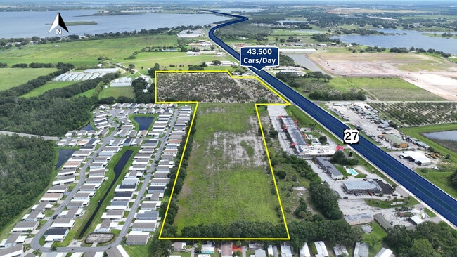
Us Highway 27, Haines City, FL 33844
NEARBY LISTINGS FOR SALE OR LEASE
Property Detail
Us Highway 27
Lakeland-Winter Haven, FL
Cypresswood
27-28-29-000000-013080
BEG INTER S LINE OF SEC & WLY R/W LINE OF US HWY 27 RUN N 11 DEG 37 MIN W 950 FT W 200 FT TO POB WEST TO WEST BDRY OF SE1/4 S ALONG 1/4 SEC LINE TO S LINE OF SEC E ALONG SEC LINE 392.25 FT N 11 DEG 37 MIN W 950 FT TO POB
Vacantlandnec
Polk
X
Florida
12105C0369G
10.54 AC
2024
Polk County
2025
Tampa/St Petersburg
012701
DEMOGRAPHICS near Us Highway 27
1 Mile
3 Mile
5 Mile
2024 Total Population
7,616
47,227
87,316
2029 Population
9,349
57,853
107,541
Pop Growth 2024-2029
+ 22.75%
+ 22.50%
+ 23.16%
Average Age
41
41
41
2024 Total Households
2,935
17,219
31,754
HH Growth 2024-2029
+ 22.96%
+ 22.57%
+ 23.12%
Median Household Inc
$40,253
$52,415
$55,045
Avg Household Size
2.60
2.70
2.70
2024 Avg HH Vehicles
1.00
2.00
2.00
Median Home Value
$115,835
$198,855
$211,081
Median Year Built
1991
1996
2000
Nearby Places
- Restaurants
- Banks
- Shops
- Fitness
- Groceries
PUBLIC TRANSPORTATION
COMMUTER RAIL
Winter Haven (Silver Meteor - Amtrak, Silver Star - Amtrak)
DRIVE
WALK
Distance
Winter Haven (Silver Meteor - Amtrak, Silver Star - Amtrak)
16 min
8.3 mi
Freight Ports
Port of Tampa Bay
DRIVE
WALK
Distance
Port of Tampa Bay
81 min
57.3 mi
SALE & LEASE HISTORY
LISTING DATE
SALE/LEASE

Jun 28, 2023
For Sale
Nearby Properties
Address
Land Use
TOTAL SIZE
Lot Size
Zoning
Address
Land Use
TOTAL SIZE
Lot Size
Zoning
138,111 SF
40.01 AC
RC
Address
Land Use
TOTAL SIZE
Lot Size
Zoning
114,089 SF
6.62 AC
Address
Land Use
TOTAL SIZE
Lot Size
Zoning
96,322 SF
8.45 AC
XX
Address
Land Use
TOTAL SIZE
Lot Size
Zoning
104,120 SF
19.25 AC
Address
Land Use
TOTAL SIZE
Lot Size
Zoning
240,920 SF
15.33 AC
AG
Address
Land Use
TOTAL SIZE
Lot Size
Zoning
147,825 SF
10.23 AC
Address
Land Use
TOTAL SIZE
Lot Size
Zoning
61,769 SF
3.91 AC
C3
Address
Land Use
TOTAL SIZE
Lot Size
Zoning
33,156 SF
9.57 AC
RC
Address
Land Use
TOTAL SIZE
Lot Size
Zoning
72,928 SF
4.73 AC
Address
Land Use
TOTAL SIZE
Lot Size
Zoning
85,890 SF
7.75 AC
C1
Address
Land Use
TOTAL SIZE
Lot Size
Zoning
35,632 SF
29.34 AC
RC
Address
Land Use
TOTAL SIZE
Lot Size
Zoning
100,177 SF
12.39 AC
XX
Address
Land Use
TOTAL SIZE
Lot Size
Zoning
74,292 SF
14.62 AC
Address
Land Use
TOTAL SIZE
Lot Size
Zoning
17,441 SF
119.40 AC
RC
Address
Land Use
TOTAL SIZE
Lot Size
Zoning
1,260 SF
473 AC
Address
Land Use
TOTAL SIZE
Lot Size
Zoning
31,565 SF
2.19 AC
Address
Land Use
TOTAL SIZE
Lot Size
Zoning
33,300 SF
8.94 AC
RC
Address
Land Use
TOTAL SIZE
Lot Size
Zoning
42,731 SF
8.14 AC
GI
Address
Land Use
TOTAL SIZE
Lot Size
Zoning
109,214 SF
14.64 AC
XX
Address
Land Use
TOTAL SIZE
Lot Size
Zoning
22,069 SF
7.74 AC
R1A
Address
Land Use
TOTAL SIZE
Lot Size
Zoning
189,241 SF
3.59 AC
C3
Address
Land Use
TOTAL SIZE
Lot Size
Zoning
70,000 SF
8.06 AC
C4
Address
Land Use
TOTAL SIZE
Lot Size
Zoning
33,962 SF
6.88 AC
C4
Address
Land Use
TOTAL SIZE
Lot Size
Zoning
15,400 SF
15.61 AC
Address
Land Use
TOTAL SIZE
Lot Size
Zoning
24.30 AC
Address
Land Use
TOTAL SIZE
Lot Size
Zoning
60,560 SF
9.33 AC
RC
Address
Land Use
TOTAL SIZE
Lot Size
Zoning
60,220 SF
12.05 AC
AG
Address
Land Use
TOTAL SIZE
Lot Size
Zoning
60,236 SF
4.90 AC
C1
Address
Land Use
TOTAL SIZE
Lot Size
Zoning
38,238 SF
1.80 AC
C1
Address
Land Use
TOTAL SIZE
Lot Size
Zoning
168,206 SF
8.43 AC
M
The World's #1 Commercial Real Estate Marketplace
Connect with us
© 2025 CoStar Group
The information above has been obtained from sources believed reliable. While we do not doubt its accuracy we have not verified it and make no guarantee, warranty or representation about it. It is your responsibility to independently confirm its accuracy and completeness. Any projections, opinions, assumptions, or estimates used are for example only and do not represent the current or future performance of the property. The value of this transaction to you depends on tax and other factors which should be evaluated by your tax, financial, and legal advisors. You and your advisors should conduct a careful, independent investigation of the property to determine to your satisfaction the suitability of the property for your needs.