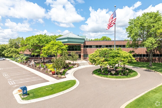
Property Record
0 Vadnais Center Dr, Vadnais Heights, MN 55110
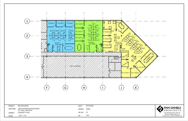

Current Lease Availabilities
NEARBY LISTINGS FOR SALE OR LEASE
Property Detail
0 Vadnais Center Dr
Minneapolis-St. Paul-Bloomington, MN-WI
Towle Addition
33-30-22-21-0015
TOWLE ADDITION OUTLOT A
Commercialacreage
Ramsey
X
Minnesota
27003C0450E
a
2024
1.62 AC
2025
Suburban St Paul
040200
Minneapolis/St Paul
DEMOGRAPHICS near 0 Vadnais Center Dr
1 Mile
3 Mile
5 Mile
2024 Total Population
4,392
55,304
174,376
2029 Population
4,263
53,930
170,588
Pop Growth 2024-2029
(2.94%)
(2.48%)
(2.17%)
Average Age
41
42
41
2024 Total Households
1,916
23,012
68,225
HH Growth 2024-2029
(3.24%)
(2.74%)
(2.30%)
Median Household Inc
$62,825
$80,290
$79,495
Avg Household Size
2.30
2.30
2.50
2024 Avg HH Vehicles
2.00
2.00
2.00
Median Home Value
$270,370
$308,071
$297,929
Median Year Built
1987
1981
1974
Nearby Places
Map Layers
Map Styles
 Street
 Aerial
- Restaurants
- Banks
- Shops
- Fitness
- Groceries
PUBLIC TRANSPORTATION
COMMUTER RAIL
St. Paul-Minneapolis (Empire Builder - Amtrak)
DRIVE
WALK
Distance
St. Paul-Minneapolis (Empire Builder - Amtrak)
13 min
8.7 mi
AIRPORT
Minneapolis-St Paul International/Wold-Chamberlain
DRIVE
WALK
Distance
Minneapolis-St Paul International/Wold-Chamberlain
28 min
18.1 mi
Freight Ports
Port Milwaukee
DRIVE
WALK
Distance
Port Milwaukee
370 min
334.6 mi
Nearby Properties
Address
Land Use
TOTAL SIZE
Lot Size
Zoning
Address
Land Use
TOTAL SIZE
Lot Size
Zoning
267,576 SF
18.95 AC
Address
Land Use
TOTAL SIZE
Lot Size
Zoning
2.39 AC
Address
Land Use
TOTAL SIZE
Lot Size
Zoning
5.59 AC
Address
Land Use
TOTAL SIZE
Lot Size
Zoning
13.44 AC
Address
Land Use
TOTAL SIZE
Lot Size
Zoning
4,800 SF
20.36 AC
Address
Land Use
TOTAL SIZE
Lot Size
Zoning
250,050 SF
2.99 AC
Address
Land Use
TOTAL SIZE
Lot Size
Zoning
106,400 SF
18.29 AC
Address
Land Use
TOTAL SIZE
Lot Size
Zoning
233,419 SF
5.67 AC
Address
Land Use
TOTAL SIZE
Lot Size
Zoning
78,163 SF
5.62 AC
Address
Land Use
TOTAL SIZE
Lot Size
Zoning
74,082 SF
12.10 AC
Address
Land Use
TOTAL SIZE
Lot Size
Zoning
212,663 SF
3.50 AC
Address
Land Use
TOTAL SIZE
Lot Size
Zoning
159.37 AC
Address
Land Use
TOTAL SIZE
Lot Size
Zoning
90,293 SF
9.33 AC
Address
Land Use
TOTAL SIZE
Lot Size
Zoning
278,392 SF
8.04 AC
Address
Land Use
TOTAL SIZE
Lot Size
Zoning
Address
Land Use
TOTAL SIZE
Lot Size
Zoning
1,500 SF
25.38 AC
Address
Land Use
TOTAL SIZE
Lot Size
Zoning
211,420 SF
5.22 AC
Address
Land Use
TOTAL SIZE
Lot Size
Zoning
17.16 AC
Address
Land Use
TOTAL SIZE
Lot Size
Zoning
212,078 SF
2.95 AC
Address
Land Use
TOTAL SIZE
Lot Size
Zoning
118,442 SF
12.83 AC
Address
Land Use
TOTAL SIZE
Lot Size
Zoning
271,355 SF
20.56 AC
Address
Land Use
TOTAL SIZE
Lot Size
Zoning
126,852 SF
11.86 AC
Address
Land Use
TOTAL SIZE
Lot Size
Zoning
67,693 SF
7.30 AC
Address
Land Use
TOTAL SIZE
Lot Size
Zoning
960 SF
17.11 AC
Address
Land Use
TOTAL SIZE
Lot Size
Zoning
209,830 SF
10.06 AC
Address
Land Use
TOTAL SIZE
Lot Size
Zoning
138,655 SF
4.70 AC
Address
Land Use
TOTAL SIZE
Lot Size
Zoning
123,360 SF
14.50 AC
Address
Land Use
TOTAL SIZE
Lot Size
Zoning
1,344 SF
14.08 AC
Address
Land Use
TOTAL SIZE
Lot Size
Zoning
7,008 SF
140.89 AC
Address
Land Use
TOTAL SIZE
Lot Size
Zoning
48,400 SF
32.18 AC
The World's #1 Commercial Real Estate Marketplace
Connect with us
© 2025 CoStar Group
The information above has been obtained from sources believed reliable. While we do not doubt its accuracy we have not verified it and make no guarantee, warranty or representation about it. It is your responsibility to independently confirm its accuracy and completeness. Any projections, opinions, assumptions, or estimates used are for example only and do not represent the current or future performance of the property. The value of this transaction to you depends on tax and other factors which should be evaluated by your tax, financial, and legal advisors. You and your advisors should conduct a careful, independent investigation of the property to determine to your satisfaction the suitability of the property for your needs.