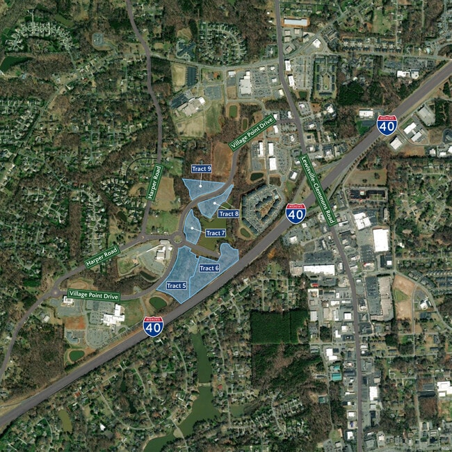
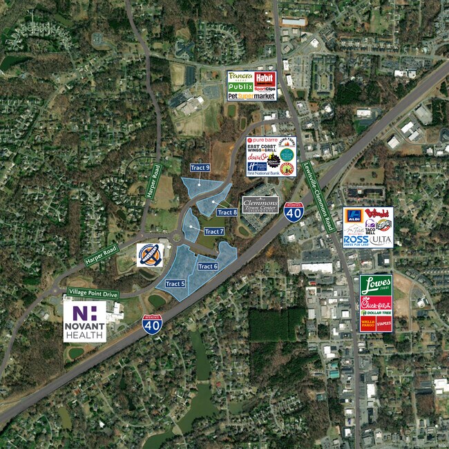
Property Record
Village Point Dr, Clemmons, NC 27012
NEARBY LISTINGS FOR SALE OR LEASE
Property Detail
Village Point Dr
Winston-Salem, NC
Clemmons North Of I-40
5883-82-0915
LO:005 BL:4312
Commercialacreage
Forsyth
X
North Carolina
3710588300J
5
2023
9.71 AC
2025
Clemmons
004014
Greensboro/Winston-Salem
1,350 SF
DEMOGRAPHICS near Village Point Dr
1 Mile
3 Mile
5 Mile
2024 Total Population
4,021
29,804
73,169
2029 Population
4,150
30,987
76,520
Pop Growth 2024-2029
+ 3.21%
+ 3.97%
+ 4.58%
Average Age
45
43
42
2024 Total Households
1,675
12,022
30,928
HH Growth 2024-2029
+ 3.22%
+ 4.02%
+ 4.54%
Median Household Inc
$87,614
$83,773
$77,549
Avg Household Size
2.30
2.40
2.30
2024 Avg HH Vehicles
2.00
2.00
2.00
Median Home Value
$277,828
$274,788
$274,731
Median Year Built
1989
1990
1990
Nearby Places
Map Layers
Map Styles
 Street
 Aerial
- Restaurants
- Banks
- Shops
- Fitness
- Groceries
PUBLIC TRANSPORTATION
AIRPORT
Piedmont Triad International
DRIVE
WALK
Distance
Piedmont Triad International
43 min
30.6 mi
Freight Ports
Port of Wilmington
DRIVE
WALK
Distance
Port of Wilmington
281 min
239.3 mi
SALE & LEASE HISTORY
LISTING DATE
SALE/LEASE

Nov 03, 2022
For Sale
Nearby Properties
Address
Land Use
TOTAL SIZE
Lot Size
Zoning
Address
Land Use
TOTAL SIZE
Lot Size
Zoning
130,696 SF
41.18 AC
PB-S
Address
Land Use
TOTAL SIZE
Lot Size
Zoning
100,233 SF
19.65 AC
PB-S
Address
Land Use
TOTAL SIZE
Lot Size
Zoning
81,594 SF
1,147.49 AC
IP
Address
Land Use
TOTAL SIZE
Lot Size
Zoning
23,926 SF
11.36 AC
Address
Land Use
TOTAL SIZE
Lot Size
Zoning
121,563 SF
22.42 AC
PB-S
Address
Land Use
TOTAL SIZE
Lot Size
Zoning
60,258 SF
8.04 AC
PB-S
Address
Land Use
TOTAL SIZE
Lot Size
Zoning
200,651 SF
60 AC
IP
Address
Land Use
TOTAL SIZE
Lot Size
Zoning
99,812 SF
18.33 AC
RM12
Address
Land Use
TOTAL SIZE
Lot Size
Zoning
655,160 SF
52.15 AC
GI
Address
Land Use
TOTAL SIZE
Lot Size
Zoning
80,171 SF
4.32 AC
PB-S
Address
Land Use
TOTAL SIZE
Lot Size
Zoning
116,655 SF
10.16 AC
LI
Address
Land Use
TOTAL SIZE
Lot Size
Zoning
60,296 SF
0.66 AC
PB-S
Address
Land Use
TOTAL SIZE
Lot Size
Zoning
68,277 SF
9.82 AC
GB-S
Address
Land Use
TOTAL SIZE
Lot Size
Zoning
79,498 SF
10.64 AC
HB
Address
Land Use
TOTAL SIZE
Lot Size
Zoning
71,306 SF
10.36 AC
IP-S
Address
Land Use
TOTAL SIZE
Lot Size
Zoning
129,268 SF
9.98 AC
HB-S
Address
Land Use
TOTAL SIZE
Lot Size
Zoning
75,361 SF
15.20 AC
RM12
Address
Land Use
TOTAL SIZE
Lot Size
Zoning
44,836 SF
14.01 AC
RM12
Address
Land Use
TOTAL SIZE
Lot Size
Zoning
101,346 SF
8.25 AC
HB-S
Address
Land Use
TOTAL SIZE
Lot Size
Zoning
52,554 SF
25.46 AC
RS9
Address
Land Use
TOTAL SIZE
Lot Size
Zoning
53,969 SF
10.52 AC
RM12-S
Address
Land Use
TOTAL SIZE
Lot Size
Zoning
119,240 SF
22.72 AC
Address
Land Use
TOTAL SIZE
Lot Size
Zoning
69,062 SF
13.44 AC
RM18
Address
Land Use
TOTAL SIZE
Lot Size
Zoning
32,696 SF
1.64 AC
PB-S
Address
Land Use
TOTAL SIZE
Lot Size
Zoning
32,656 SF
3.14 AC
IP-S
Address
Land Use
TOTAL SIZE
Lot Size
Zoning
68,028 SF
17.56 AC
IP
Address
Land Use
TOTAL SIZE
Lot Size
Zoning
63,600 SF
11.40 AC
NSB-S
Address
Land Use
TOTAL SIZE
Lot Size
Zoning
79,355 SF
14.91 AC
IP-S
Address
Land Use
TOTAL SIZE
Lot Size
Zoning
60,709 SF
34.21 AC
C-S
Address
Land Use
TOTAL SIZE
Lot Size
Zoning
46,094 SF
14.02 AC
IP,RM8
The World's #1 Commercial Real Estate Marketplace
Connect with us
© 2026 CoStar Group
The information above has been obtained from sources believed reliable. While we do not doubt its accuracy we have not verified it and make no guarantee, warranty or representation about it. It is your responsibility to independently confirm its accuracy and completeness. Any projections, opinions, assumptions, or estimates used are for example only and do not represent the current or future performance of the property. The value of this transaction to you depends on tax and other factors which should be evaluated by your tax, financial, and legal advisors. You and your advisors should conduct a careful, independent investigation of the property to determine to your satisfaction the suitability of the property for your needs.