Property Record
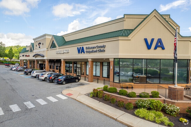
0 W Chester Park, Newtown Square, PA 19073


NEARBY LISTINGS FOR SALE OR LEASE
Property Detail
0 W Chester Park
19-00-00419-15
1 STY BLDG 4.218AC LOT B
Regionalshoppingcenterormallwithanchorstore
Delaware
A
Pennsylvania
42029C0220G
b
2024
4.22 AC
2025
Delaware County
409902
Philadelphia
34,140 SF
Philadelphia-Camden-Wilmington, PA-NJ-DE-MD
DEMOGRAPHICS near 0 W Chester Park
1 Mile
3 Mile
5 Mile
2024 Total Population
1,699
22,135
98,152
2029 Population
1,674
22,414
99,074
Pop Growth 2024-2029
(1.47%)
+ 1.26%
+ 0.94%
Average Age
46
46
44
2024 Total Households
701
8,920
38,305
HH Growth 2024-2029
(1.71%)
+ 1.49%
+ 1.01%
Median Household Inc
$107,337
$130,511
$123,742
Avg Household Size
2.40
2.40
2.50
2024 Avg HH Vehicles
2.00
2.00
2.00
Median Home Value
$562,500
$637,840
$551,390
Median Year Built
1987
1981
1970
Nearby Places
Map Layers
Map Styles
 Street
 Aerial
- Restaurants
- Banks
- Shops
- Fitness
- Groceries
PUBLIC TRANSPORTATION
COMMUTER RAIL
Media (R3 - Southeastern Pennsylvania Transportation Authority Regional Rail (SEPTA Regional Rail))
DRIVE
WALK
Distance
Media (R3 - Southeastern Pennsylvania Transportation Authority Regional Rail (SEPTA Regional Rail))
14 min
6.4 mi
Daylesford (R5 - Southeastern Pennsylvania Transportation Authority Regional Rail (SEPTA Regional Rail))
DRIVE
WALK
Distance
Daylesford (R5 - Southeastern Pennsylvania Transportation Authority Regional Rail (SEPTA Regional Rail))
16 min
9.2 mi
AIRPORT
Philadelphia International
DRIVE
WALK
Distance
Philadelphia International
30 min
17.2 mi
Freight Ports
South Jersey Port
DRIVE
WALK
Distance
South Jersey Port
43 min
20.4 mi
Nearby Properties
Address
Land Use
TOTAL SIZE
Lot Size
Zoning
Address
Land Use
TOTAL SIZE
Lot Size
Zoning
227,940 SF
110.24 AC
Address
Land Use
TOTAL SIZE
Lot Size
Zoning
192,800 SF
129.66 AC
Address
Land Use
TOTAL SIZE
Lot Size
Zoning
259,200 SF
21.14 AC
Address
Land Use
TOTAL SIZE
Lot Size
Zoning
45,294 SF
83.20 AC
Address
Land Use
TOTAL SIZE
Lot Size
Zoning
84,920 SF
81.65 AC
Address
Land Use
TOTAL SIZE
Lot Size
Zoning
Address
Land Use
TOTAL SIZE
Lot Size
Zoning
60,768 SF
16.17 AC
Address
Land Use
TOTAL SIZE
Lot Size
Zoning
26.47 AC
Address
Land Use
TOTAL SIZE
Lot Size
Zoning
73,059 SF
10.17 AC
Address
Land Use
TOTAL SIZE
Lot Size
Zoning
1,596 SF
21.92 AC
Address
Land Use
TOTAL SIZE
Lot Size
Zoning
264,399 SF
122.05 AC
Address
Land Use
TOTAL SIZE
Lot Size
Zoning
23,868 SF
11.18 AC
Address
Land Use
TOTAL SIZE
Lot Size
Zoning
185,720 SF
0.50 AC
Address
Land Use
TOTAL SIZE
Lot Size
Zoning
238,024 SF
3.07 AC
Address
Land Use
TOTAL SIZE
Lot Size
Zoning
168,474 SF
1 AC
Address
Land Use
TOTAL SIZE
Lot Size
Zoning
78,881 SF
54.66 AC
Address
Land Use
TOTAL SIZE
Lot Size
Zoning
93,068 SF
12.47 AC
Address
Land Use
TOTAL SIZE
Lot Size
Zoning
331,021 SF
35.19 AC
Address
Land Use
TOTAL SIZE
Lot Size
Zoning
37,176 SF
13 AC
Address
Land Use
TOTAL SIZE
Lot Size
Zoning
Address
Land Use
TOTAL SIZE
Lot Size
Zoning
88,056 SF
10.98 AC
Address
Land Use
TOTAL SIZE
Lot Size
Zoning
55,439 SF
1.82 AC
Address
Land Use
TOTAL SIZE
Lot Size
Zoning
103,176 SF
16.38 AC
Address
Land Use
TOTAL SIZE
Lot Size
Zoning
132,579 SF
14.35 AC
Address
Land Use
TOTAL SIZE
Lot Size
Zoning
16,085 SF
247.85 AC
Address
Land Use
TOTAL SIZE
Lot Size
Zoning
67,920 SF
1 AC
Address
Land Use
TOTAL SIZE
Lot Size
Zoning
15,448 SF
28.48 AC
Address
Land Use
TOTAL SIZE
Lot Size
Zoning
41,400 SF
6.15 AC
Address
Land Use
TOTAL SIZE
Lot Size
Zoning
38,840 SF
44.76 AC
Address
Land Use
TOTAL SIZE
Lot Size
Zoning
65,504 SF
12.73 AC
The World's #1 Commercial Real Estate Marketplace
Connect with us
© 2026 CoStar Group
The information above has been obtained from sources believed reliable. While we do not doubt its accuracy we have not verified it and make no guarantee, warranty or representation about it. It is your responsibility to independently confirm its accuracy and completeness. Any projections, opinions, assumptions, or estimates used are for example only and do not represent the current or future performance of the property. The value of this transaction to you depends on tax and other factors which should be evaluated by your tax, financial, and legal advisors. You and your advisors should conduct a careful, independent investigation of the property to determine to your satisfaction the suitability of the property for your needs.