Property Record
County Road 210 W, Saint Johns, FL 32259


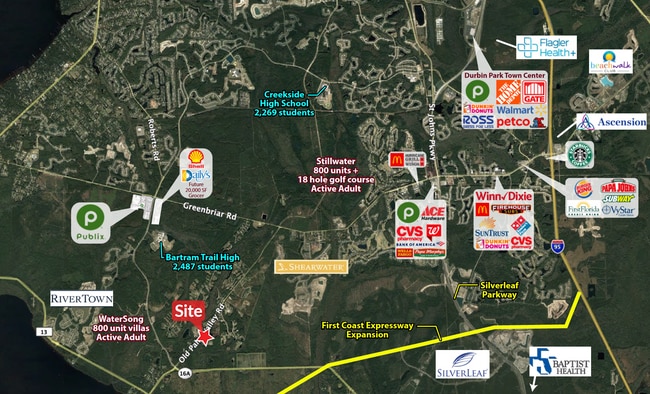
This Property Is For Sale
Property Detail
County Road 210 W
Jacksonville, FL
1-5 ALL NW1/4 OF NE1/4 OF SW 1/4 & PT OF NW1/4 LYING SE OF CR210 - PARCEL A (EX PTS IN OR1908/948 & OR2169/1377)(EX PT IN OR2269/1209) OR2276/1828
010270-0050
ST. JOHNS
Timberlandforesttreesagricultural
Florida
OR
1-5
B and X Area of moderate flood hazard, usually the area between the limits of the 100-year and 500-year floods.
14.04 AC
2025
St Johns County
2026
Jacksonville (Florida)
020809
NEARBY LISTINGS FOR SALE OR LEASE
DEMOGRAPHICS near County Road 210 W
1 mile
3 mile
5 mile
2025 Total Population
426
15,925
47,547
2030 Population
522
19,283
56,093
Pop Growth 2025-2030
+ 22.54%
+ 21.09%
+ 17.97%
Average Age
38
38
39
2025 Total Households
136
5,137
15,275
HH Growth 2025-2030
+ 22.06%
+ 21.35%
+ 18.33%
Median Household Inc
$144,736
$148,887
$144,233
Avg Household Size
3.10
3.10
3.10
2025 Avg HH Vehicles
2.00
2.00
2.00
Median Home Value
$707,317
$689,281
$629,071
Median Year Built
2011
2011
2010
Nearby Places
Map Layers
Map Styles
 Street
 Aerial
Layers
 Traffic
 Biking
Places
Listings with unknown addresses are not visible on the map
- Restaurants
- Banks
- Shops
- Fitness
- Groceries
PUBLIC TRANSPORTATION
AIRPORT
Jacksonville International
Drive
Walk
Distance
Jacksonville International
56 min
41.9 mi
Freight Ports
Jacksonville Port
Drive
Walk
Distance
Jacksonville Port
44 min
30.8 mi
Nearby Properties
Address
Land Use
TOTAL SIZE
Lot Size
Zoning
Address
Land Use
TOTAL SIZE
Lot Size
Zoning
388,481 SF
18.61 AC
Address
Land Use
TOTAL SIZE
Lot Size
Zoning
276,285 SF
121.14 AC
OR
Address
Land Use
TOTAL SIZE
Lot Size
Zoning
111,591 SF
26.45 AC
Address
Land Use
TOTAL SIZE
Lot Size
Zoning
70,108 SF
32.90 AC
Address
Land Use
TOTAL SIZE
Lot Size
Zoning
104,451 SF
30.04 AC
OR
Address
Land Use
TOTAL SIZE
Lot Size
Zoning
Address
Land Use
TOTAL SIZE
Lot Size
Zoning
471.10 AC
Address
Land Use
TOTAL SIZE
Lot Size
Zoning
51.52 AC
OR
Address
Land Use
TOTAL SIZE
Lot Size
Zoning
38.57 AC
Address
Land Use
TOTAL SIZE
Lot Size
Zoning
14,485 SF
67.53 AC
OR
Address
Land Use
TOTAL SIZE
Lot Size
Zoning
44.72 AC
PUD
Address
Land Use
TOTAL SIZE
Lot Size
Zoning
9,210 SF
3.26 AC
Address
Land Use
TOTAL SIZE
Lot Size
Zoning
166.53 AC
PUD
Address
Land Use
TOTAL SIZE
Lot Size
Zoning
13,198 SF
2,073.46 AC
OR
Address
Land Use
TOTAL SIZE
Lot Size
Zoning
24,338 SF
12.58 AC
OR
Address
Land Use
TOTAL SIZE
Lot Size
Zoning
4,790 SF
1.53 AC
Address
Land Use
TOTAL SIZE
Lot Size
Zoning
Address
Land Use
TOTAL SIZE
Lot Size
Zoning
12,098 SF
1.73 AC
Address
Land Use
TOTAL SIZE
Lot Size
Zoning
11,004 SF
2.31 AC
OR
Address
Land Use
TOTAL SIZE
Lot Size
Zoning
Address
Land Use
TOTAL SIZE
Lot Size
Zoning
1,279 SF
0.85 AC
Address
Land Use
TOTAL SIZE
Lot Size
Zoning
2,255 SF
1.22 AC
Address
Land Use
TOTAL SIZE
Lot Size
Zoning
2,551 SF
190.11 AC
Address
Land Use
TOTAL SIZE
Lot Size
Zoning
265.07 AC
Address
Land Use
TOTAL SIZE
Lot Size
Zoning
2,127 SF
15.83 AC
Address
Land Use
TOTAL SIZE
Lot Size
Zoning
5,040 SF
0.96 AC
Address
Land Use
TOTAL SIZE
Lot Size
Zoning
7,866 SF
0.83 AC
Address
Land Use
TOTAL SIZE
Lot Size
Zoning
10,027 SF
2 AC
RS2
Address
Land Use
TOTAL SIZE
Lot Size
Zoning
39.41 AC
OR
Address
Land Use
TOTAL SIZE
Lot Size
Zoning
The World's #1 Commercial Real Estate Marketplace
Connect with us
© 2026 CoStar Group
The information above has been obtained from sources believed reliable. While we do not doubt its accuracy we have not verified it and make no guarantee, warranty or representation about it. It is your responsibility to independently confirm its accuracy and completeness. Any projections, opinions, assumptions, or estimates used are for example only and do not represent the current or future performance of the property. The value of this transaction to you depends on tax and other factors which should be evaluated by your tax, financial, and legal advisors. You and your advisors should conduct a careful, independent investigation of the property to determine to your satisfaction the suitability of the property for your needs.