Property Record
Walnut Dale Dr, Wayland, MI 49348
NEARBY LISTINGS FOR SALE OR LEASE
-
-
View all Wayland listings for sale on LoopNet.com
Property Detail
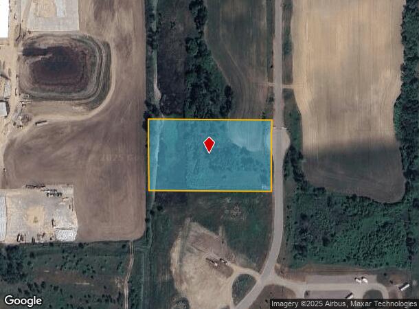
Walnut Dale Dr
Holland, MI
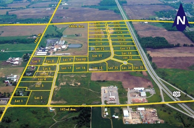
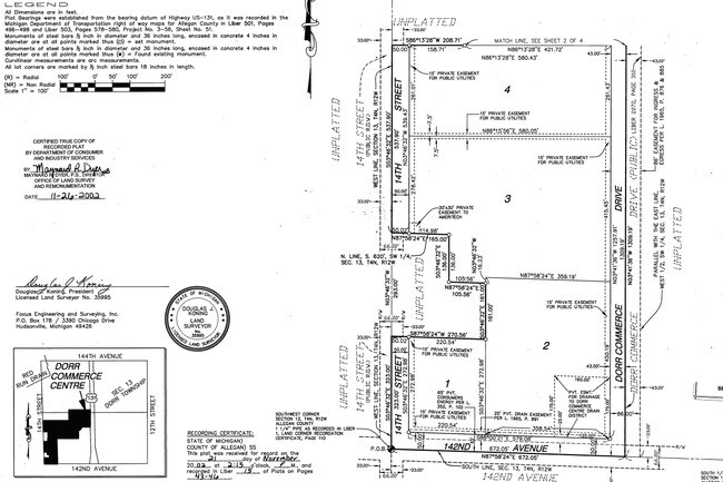
Dorr Commerce Centre
05-160-012-00
LOT 12 DORR COMMERCE CENTRE SEC 13 T4N R12W TAX MAP: 3.54 AC (03).
Industrialacreage
Allegan
X
Michigan
26005C0260G
12
2024
3.53 AC
2025
Outlying Allegan County
030502
West Michigan
DEMOGRAPHICS near Walnut Dale Dr
1 Mile
3 Mile
5 Mile
2024 Total Population
1,189
7,511
19,910
2029 Population
1,187
7,483
20,069
Pop Growth 2024-2029
(0.17%)
(0.37%)
+ 0.80%
Average Age
36
37
37
2024 Total Households
399
2,538
6,857
HH Growth 2024-2029
(0.25%)
(0.47%)
+ 0.70%
Median Household Inc
$83,035
$80,730
$80,305
Avg Household Size
2.90
2.90
2.80
2024 Avg HH Vehicles
2.00
2.00
2.00
Median Home Value
$236,423
$231,062
$238,786
Median Year Built
1991
1984
1986
Nearby Places
- Restaurants
- Banks
- Shops
- Fitness
- Groceries
PUBLIC TRANSPORTATION
AIRPORT
Gerald R Ford International
DRIVE
WALK
Distance
Gerald R Ford International
30 min
19.7 mi
Freight Ports
Port Milwaukee
DRIVE
WALK
Distance
Port Milwaukee
304 min
260.6 mi
SALE & LEASE HISTORY
LISTING DATE
SALE/LEASE

Sep 24, 2016
For Sale
Nearby Properties
Address
Land Use
TOTAL SIZE
Lot Size
Zoning
Address
Land Use
TOTAL SIZE
Lot Size
Zoning
119.76 AC
Address
Land Use
TOTAL SIZE
Lot Size
Zoning
132,905 SF
58.60 AC
Address
Land Use
TOTAL SIZE
Lot Size
Zoning
54,240 SF
36.50 AC
Address
Land Use
TOTAL SIZE
Lot Size
Zoning
56,370 SF
6.54 AC
Address
Land Use
TOTAL SIZE
Lot Size
Zoning
172,000 SF
9.60 AC
Address
Land Use
TOTAL SIZE
Lot Size
Zoning
196,250 SF
24.59 AC
Address
Land Use
TOTAL SIZE
Lot Size
Zoning
44,250 SF
37.35 AC
Address
Land Use
TOTAL SIZE
Lot Size
Zoning
145,000 SF
11.85 AC
Address
Land Use
TOTAL SIZE
Lot Size
Zoning
2,351 SF
139 AC
AGRICUL
Address
Land Use
TOTAL SIZE
Lot Size
Zoning
78,120 SF
4.13 AC
Address
Land Use
TOTAL SIZE
Lot Size
Zoning
121,666 SF
16.04 AC
Address
Land Use
TOTAL SIZE
Lot Size
Zoning
31,890 SF
14 AC
Address
Land Use
TOTAL SIZE
Lot Size
Zoning
32,825 SF
5.05 AC
Address
Land Use
TOTAL SIZE
Lot Size
Zoning
35,400 SF
Address
Land Use
TOTAL SIZE
Lot Size
Zoning
52,071 SF
9.60 AC
Address
Land Use
TOTAL SIZE
Lot Size
Zoning
24,999 SF
8.79 AC
Address
Land Use
TOTAL SIZE
Lot Size
Zoning
46,060 SF
11.88 AC
Address
Land Use
TOTAL SIZE
Lot Size
Zoning
80,280 SF
12.73 AC
Address
Land Use
TOTAL SIZE
Lot Size
Zoning
72,175 SF
4.30 AC
Address
Land Use
TOTAL SIZE
Lot Size
Zoning
197.92 AC
Address
Land Use
TOTAL SIZE
Lot Size
Zoning
12,000 SF
6.47 AC
Address
Land Use
TOTAL SIZE
Lot Size
Zoning
7,200 SF
77.64 AC
I INDUS
Address
Land Use
TOTAL SIZE
Lot Size
Zoning
33,164 SF
6.88 AC
Address
Land Use
TOTAL SIZE
Lot Size
Zoning
640 SF
38.25 AC
Address
Land Use
TOTAL SIZE
Lot Size
Zoning
12,320 SF
4.96 AC
Address
Land Use
TOTAL SIZE
Lot Size
Zoning
16,700 SF
29.08 AC
D1
Address
Land Use
TOTAL SIZE
Lot Size
Zoning
33,528 SF
10 AC
Address
Land Use
TOTAL SIZE
Lot Size
Zoning
47,588 SF
3.15 AC
Address
Land Use
TOTAL SIZE
Lot Size
Zoning
16,160 SF
5.48 AC
Address
Land Use
TOTAL SIZE
Lot Size
Zoning
25,900 SF
2.67 AC
The World's #1 Commercial Real Estate Marketplace
Connect with us
© 2025 CoStar Group
The information above has been obtained from sources believed reliable. While we do not doubt its accuracy we have not verified it and make no guarantee, warranty or representation about it. It is your responsibility to independently confirm its accuracy and completeness. Any projections, opinions, assumptions, or estimates used are for example only and do not represent the current or future performance of the property. The value of this transaction to you depends on tax and other factors which should be evaluated by your tax, financial, and legal advisors. You and your advisors should conduct a careful, independent investigation of the property to determine to your satisfaction the suitability of the property for your needs.