Property Record
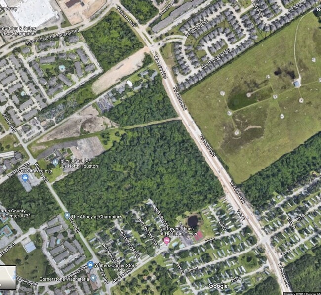
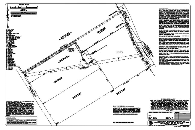
0 Walters Rd, Houston, TX 77014


This Property Is For Sale
Property Detail
0 Walters Rd
Houston-Pasadena-The Woodlands, TX
TR 3A ABST 742 J SCHNELL
0450460000056
HARRIS
Transportnec
Texas
B and X Area of moderate flood hazard, usually the area between the limits of the 100-year and 500-year floods.
10.65 AC
2024
FM 1960/Champions
2025
Houston
550407
NEARBY LISTINGS FOR SALE OR LEASE
DEMOGRAPHICS near 0 Walters Rd
1 mile
3 mile
5 mile
2025 Total Population
14,099
135,057
338,634
2030 Population
15,022
143,697
359,636
Pop Growth 2025-2030
+ 6.55%
+ 6.40%
+ 6.20%
Average Age
37
37
36
2025 Total Households
5,184
46,844
116,499
HH Growth 2025-2030
+ 6.85%
+ 6.72%
+ 6.50%
Median Household Inc
$51,353
$66,074
$68,246
Avg Household Size
2.60
2.80
2.80
2025 Avg HH Vehicles
2.00
2.00
2.00
Median Home Value
$263,832
$265,474
$272,722
Median Year Built
1994
1987
1989
Nearby Places
Map Layers
Map Styles
 Street
 Aerial
Layers
 Traffic
 Biking
Places
Listings with unknown addresses are not visible on the map
- Restaurants
- Banks
- Shops
- Fitness
- Groceries
PUBLIC TRANSPORTATION
AIRPORT
George Bush Intcntl/Houston
Drive
Walk
Distance
George Bush Intcntl/Houston
20 min
12.6 mi
William P Hobby
Drive
Walk
Distance
William P Hobby
49 min
31.9 mi
Freight Ports
Port of Houston
Drive
Walk
Distance
Port of Houston
41 min
27.5 mi
Nearby Properties
Address
Land Use
TOTAL SIZE
Lot Size
Zoning
Address
Land Use
TOTAL SIZE
Lot Size
Zoning
734,137 SF
11.37 AC
Address
Land Use
TOTAL SIZE
Lot Size
Zoning
180,249 SF
13.35 AC
Address
Land Use
TOTAL SIZE
Lot Size
Zoning
402,504 SF
31.93 AC
Address
Land Use
TOTAL SIZE
Lot Size
Zoning
286,090 SF
13.25 AC
Address
Land Use
TOTAL SIZE
Lot Size
Zoning
423,472 SF
28.91 AC
Address
Land Use
TOTAL SIZE
Lot Size
Zoning
378,316 SF
17.34 AC
Address
Land Use
TOTAL SIZE
Lot Size
Zoning
335,106 SF
13.27 AC
Address
Land Use
TOTAL SIZE
Lot Size
Zoning
304,518 SF
15 AC
Address
Land Use
TOTAL SIZE
Lot Size
Zoning
326,920 SF
22.26 AC
Address
Land Use
TOTAL SIZE
Lot Size
Zoning
454,632 SF
18.69 AC
Address
Land Use
TOTAL SIZE
Lot Size
Zoning
130,470 SF
9.22 AC
Address
Land Use
TOTAL SIZE
Lot Size
Zoning
404,248 SF
16.31 AC
Address
Land Use
TOTAL SIZE
Lot Size
Zoning
237,292 SF
11.91 AC
Address
Land Use
TOTAL SIZE
Lot Size
Zoning
339,804 SF
14.21 AC
Address
Land Use
TOTAL SIZE
Lot Size
Zoning
247,670 SF
13.38 AC
Address
Land Use
TOTAL SIZE
Lot Size
Zoning
218,967 SF
14.11 AC
Address
Land Use
TOTAL SIZE
Lot Size
Zoning
227,196 SF
13.84 AC
Address
Land Use
TOTAL SIZE
Lot Size
Zoning
268,232 SF
12.33 AC
Address
Land Use
TOTAL SIZE
Lot Size
Zoning
221,352 SF
17.35 AC
Address
Land Use
TOTAL SIZE
Lot Size
Zoning
205,054 SF
10.05 AC
Address
Land Use
TOTAL SIZE
Lot Size
Zoning
174,751 SF
10.49 AC
Address
Land Use
TOTAL SIZE
Lot Size
Zoning
204,633 SF
10.44 AC
Address
Land Use
TOTAL SIZE
Lot Size
Zoning
241,244 SF
10.92 AC
Address
Land Use
TOTAL SIZE
Lot Size
Zoning
269,308 SF
10.28 AC
Address
Land Use
TOTAL SIZE
Lot Size
Zoning
328,568 SF
14.14 AC
Address
Land Use
TOTAL SIZE
Lot Size
Zoning
286,341 SF
10.35 AC
Address
Land Use
TOTAL SIZE
Lot Size
Zoning
223,662 SF
10.79 AC
Address
Land Use
TOTAL SIZE
Lot Size
Zoning
215,133 SF
9.26 AC
Address
Land Use
TOTAL SIZE
Lot Size
Zoning
263,990 SF
10.98 AC
Address
Land Use
TOTAL SIZE
Lot Size
Zoning
194,816 SF
8 AC
The World's #1 Commercial Real Estate Marketplace
Connect with us
© 2026 CoStar Group
The information above has been obtained from sources believed reliable. While we do not doubt its accuracy we have not verified it and make no guarantee, warranty or representation about it. It is your responsibility to independently confirm its accuracy and completeness. Any projections, opinions, assumptions, or estimates used are for example only and do not represent the current or future performance of the property. The value of this transaction to you depends on tax and other factors which should be evaluated by your tax, financial, and legal advisors. You and your advisors should conduct a careful, independent investigation of the property to determine to your satisfaction the suitability of the property for your needs.