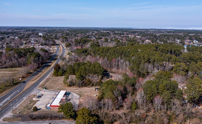
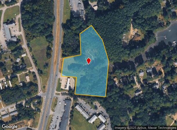
Property Record
Waters Edge Ln, , VA
NEARBY LISTINGS FOR SALE OR LEASE
Property Detail
Waters Edge Ln
Virginia Beach-Norfolk-Newport News, VA-NC
Plat: Pb21 839
32998
GLOUCESTER POINT PARCEL B SARAH CREEK NORTHWEST BRANCH
Realpropertynec
Gloucester
AE
Virginia
51073C0213F
4.83 AC
2025
Gloucester
2025
Hampton Roads
100301
DEMOGRAPHICS near Waters Edge Ln
1 Mile
3 Mile
5 Mile
2024 Total Population
4,104
11,201
22,769
2029 Population
4,223
11,535
23,497
Pop Growth 2024-2029
+ 2.90%
+ 2.98%
+ 3.20%
Average Age
44
42
42
2024 Total Households
1,803
4,632
9,067
HH Growth 2024-2029
+ 2.83%
+ 2.85%
+ 3.10%
Median Household Inc
$65,557
$65,121
$80,360
Avg Household Size
2.30
2.30
2.40
2024 Avg HH Vehicles
2.00
2.00
2.00
Median Home Value
$274,453
$277,787
$326,166
Median Year Built
1977
1980
1982
Nearby Places
Map Layers
Map Styles
 Street
 Aerial
- Restaurants
- Banks
- Shops
- Fitness
- Groceries
PUBLIC TRANSPORTATION
AIRPORT
Newport News/Williamsburg International
DRIVE
WALK
Distance
Newport News/Williamsburg International
20 min
11.9 mi
Freight Ports
Virginia Port Authority - Newport News
DRIVE
WALK
Distance
Virginia Port Authority - Newport News
38 min
25.2 mi
SALE & LEASE HISTORY
LISTING DATE
SALE/LEASE

Mar 27, 2025
For Sale
Nearby Properties
Address
Land Use
TOTAL SIZE
Lot Size
Zoning
Address
Land Use
TOTAL SIZE
Lot Size
Zoning
81,600 SF
21 AC
RESOURCE C
Address
Land Use
TOTAL SIZE
Lot Size
Zoning
54,032 SF
0.49 AC
SF-1
Address
Land Use
TOTAL SIZE
Lot Size
Zoning
133,173 SF
27.21 AC
RESOURCE C
Address
Land Use
TOTAL SIZE
Lot Size
Zoning
57,012 SF
1.82 AC
SF-1
Address
Land Use
TOTAL SIZE
Lot Size
Zoning
46,690 SF
3.50 AC
YORKTOWN V
Address
Land Use
TOTAL SIZE
Lot Size
Zoning
19,301 SF
5.27 AC
YORKTOWN V
Address
Land Use
TOTAL SIZE
Lot Size
Zoning
86,535 SF
9.63 AC
SF-1
Address
Land Use
TOTAL SIZE
Lot Size
Zoning
30,160 SF
25.83 AC
B-1
Address
Land Use
TOTAL SIZE
Lot Size
Zoning
43,755 SF
0.92 AC
SF-1
Address
Land Use
TOTAL SIZE
Lot Size
Zoning
10,098 SF
10.50 AC
MF-1
Address
Land Use
TOTAL SIZE
Lot Size
Zoning
40,400 SF
0.55 AC
SF-1
Address
Land Use
TOTAL SIZE
Lot Size
Zoning
37,510 SF
11.59 AC
B-1
Address
Land Use
TOTAL SIZE
Lot Size
Zoning
43,716 SF
0.42 AC
YORKTOWN V
Address
Land Use
TOTAL SIZE
Lot Size
Zoning
14,814 SF
2.63 AC
B-1
Address
Land Use
TOTAL SIZE
Lot Size
Zoning
14,697 SF
6.47 AC
MF-1
Address
Land Use
TOTAL SIZE
Lot Size
Zoning
14,872 SF
2.80 AC
B-1
Address
Land Use
TOTAL SIZE
Lot Size
Zoning
21,752 SF
5.35 AC
YORKTOWN V
Address
Land Use
TOTAL SIZE
Lot Size
Zoning
25,156 SF
10 AC
SC-1
Address
Land Use
TOTAL SIZE
Lot Size
Zoning
58,296 SF
4.46 AC
MULTI-FAMI
Address
Land Use
TOTAL SIZE
Lot Size
Zoning
45,236 SF
3.40 AC
B-1
Address
Land Use
TOTAL SIZE
Lot Size
Zoning
39,198 SF
1.31 AC
YORKTOWN V
Address
Land Use
TOTAL SIZE
Lot Size
Zoning
9,220 SF
2.22 AC
C-2
Address
Land Use
TOTAL SIZE
Lot Size
Zoning
46,800 SF
6.37 AC
MULTI-FAMI
Address
Land Use
TOTAL SIZE
Lot Size
Zoning
0.50 AC
YORKTOWN V
Address
Land Use
TOTAL SIZE
Lot Size
Zoning
40,720 SF
1.23 AC
B-1
Address
Land Use
TOTAL SIZE
Lot Size
Zoning
26,084 SF
1.52 AC
YORKTOWN V
Address
Land Use
TOTAL SIZE
Lot Size
Zoning
1,728 SF
1.34 AC
B-1
Address
Land Use
TOTAL SIZE
Lot Size
Zoning
8,745 SF
0.49 AC
YORKTOWN V
Address
Land Use
TOTAL SIZE
Lot Size
Zoning
16,399 SF
3.91 AC
SF-1
Address
Land Use
TOTAL SIZE
Lot Size
Zoning
2,554 SF
2.54 AC
B-2
The World's #1 Commercial Real Estate Marketplace
Connect with us
© 2025 CoStar Group
The information above has been obtained from sources believed reliable. While we do not doubt its accuracy we have not verified it and make no guarantee, warranty or representation about it. It is your responsibility to independently confirm its accuracy and completeness. Any projections, opinions, assumptions, or estimates used are for example only and do not represent the current or future performance of the property. The value of this transaction to you depends on tax and other factors which should be evaluated by your tax, financial, and legal advisors. You and your advisors should conduct a careful, independent investigation of the property to determine to your satisfaction the suitability of the property for your needs.