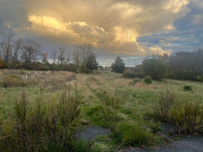
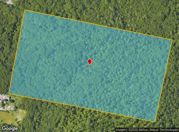
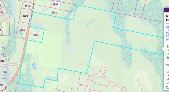
Property Record
Hart St, Dighton, MA 02715
NEARBY LISTINGS FOR SALE OR LEASE
-
-
View all Dighton listings for sale on LoopNet.com
Property Detail
Hart St
DIGH-000021-000017
Bristol
Nonbuildableland
Massachusetts
X
29.30 AC
25005C0241F
Attleboro/New Bedford
2025
Boston
2025
Providence-Warwick, RI-MA
615100
DEMOGRAPHICS near Hart St
1 Mile
3 Mile
5 Mile
2024 Total Population
767
15,117
46,731
2029 Population
786
15,464
47,764
Pop Growth 2024-2029
+ 2.48%
+ 2.30%
+ 2.21%
Average Age
40
42
43
2024 Total Households
262
5,398
17,706
HH Growth 2024-2029
+ 2.67%
+ 2.35%
+ 2.29%
Median Household Inc
$129,167
$120,299
$111,115
Avg Household Size
2.90
2.80
2.60
2024 Avg HH Vehicles
2.00
2.00
2.00
Median Home Value
$591,085
$499,193
$472,849
Median Year Built
1994
1977
1973
Nearby Places
Map Layers
Map Styles
 Street
 Aerial
- Restaurants
- Banks
- Shops
- Fitness
- Groceries
PUBLIC TRANSPORTATION
AIRPORT
Rhode Island Tf Green International
DRIVE
WALK
Distance
Rhode Island Tf Green International
41 min
24.5 mi
Freight Ports
Port of New Bedford Harbor
DRIVE
WALK
Distance
Port of New Bedford Harbor
35 min
23.5 mi
SALE & LEASE HISTORY
LISTING DATE
SALE/LEASE

Nov 11, 2025
For Sale
Nearby Properties
Address
Land Use
TOTAL SIZE
Lot Size
Zoning
Address
Land Use
TOTAL SIZE
Lot Size
Zoning
104,822 SF
16.61 AC
R1
Address
Land Use
TOTAL SIZE
Lot Size
Zoning
28,438 SF
245 AC
C
Address
Land Use
TOTAL SIZE
Lot Size
Zoning
76,960 SF
23.40 AC
C
Address
Land Use
TOTAL SIZE
Lot Size
Zoning
83,628 SF
5.51 AC
R1
Address
Land Use
TOTAL SIZE
Lot Size
Zoning
17.50 AC
I
Address
Land Use
TOTAL SIZE
Lot Size
Zoning
7,867 SF
27 AC
R1
Address
Land Use
TOTAL SIZE
Lot Size
Zoning
8.04 AC
R1
Address
Land Use
TOTAL SIZE
Lot Size
Zoning
68,243 SF
4.73 AC
C
Address
Land Use
TOTAL SIZE
Lot Size
Zoning
27,540 SF
3.57 AC
R1
Address
Land Use
TOTAL SIZE
Lot Size
Zoning
27,540 SF
3.57 AC
R1
Address
Land Use
TOTAL SIZE
Lot Size
Zoning
15 AC
R1
Address
Land Use
TOTAL SIZE
Lot Size
Zoning
89.30 AC
R1
Address
Land Use
TOTAL SIZE
Lot Size
Zoning
9,584 SF
9.90 AC
R1
Address
Land Use
TOTAL SIZE
Lot Size
Zoning
2,104 SF
3.68 AC
C
Address
Land Use
TOTAL SIZE
Lot Size
Zoning
31,682 SF
2.59 AC
C
Address
Land Use
TOTAL SIZE
Lot Size
Zoning
41,750 SF
6.30 AC
C
Address
Land Use
TOTAL SIZE
Lot Size
Zoning
2.68 AC
R1
Address
Land Use
TOTAL SIZE
Lot Size
Zoning
7,516 SF
9.84 AC
C
Address
Land Use
TOTAL SIZE
Lot Size
Zoning
9,740 SF
3 AC
C
Address
Land Use
TOTAL SIZE
Lot Size
Zoning
2,980 SF
93.69 AC
R1
Address
Land Use
TOTAL SIZE
Lot Size
Zoning
21,758 SF
10.19 AC
Address
Land Use
TOTAL SIZE
Lot Size
Zoning
4,792 SF
6.14 AC
Address
Land Use
TOTAL SIZE
Lot Size
Zoning
3,600 SF
7.70 AC
R1
Address
Land Use
TOTAL SIZE
Lot Size
Zoning
7.04 AC
R1
Address
Land Use
TOTAL SIZE
Lot Size
Zoning
1,550 SF
10 AC
C
Address
Land Use
TOTAL SIZE
Lot Size
Zoning
4,694 SF
4.10 AC
R1
Address
Land Use
TOTAL SIZE
Lot Size
Zoning
5,280 SF
6.90 AC
R1
Address
Land Use
TOTAL SIZE
Lot Size
Zoning
9,914 SF
1.86 AC
C
Address
Land Use
TOTAL SIZE
Lot Size
Zoning
9,600 SF
3.04 AC
C
Address
Land Use
TOTAL SIZE
Lot Size
Zoning
3,065 SF
1.38 AC
R1
The World's #1 Commercial Real Estate Marketplace
Connect with us
© 2026 CoStar Group
The information above has been obtained from sources believed reliable. While we do not doubt its accuracy we have not verified it and make no guarantee, warranty or representation about it. It is your responsibility to independently confirm its accuracy and completeness. Any projections, opinions, assumptions, or estimates used are for example only and do not represent the current or future performance of the property. The value of this transaction to you depends on tax and other factors which should be evaluated by your tax, financial, and legal advisors. You and your advisors should conduct a careful, independent investigation of the property to determine to your satisfaction the suitability of the property for your needs.