Property Record
Woodkraft Rd, Madison, GA 30650

NEARBY LISTINGS FOR SALE OR LEASE
-
-
View all Madison listings for sale on LoopNet.com
Property Detail
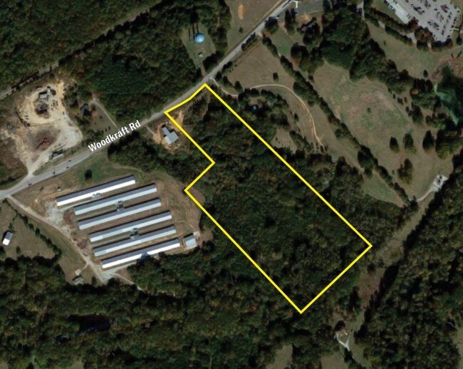
Woodkraft Rd
Atlanta-Sandy Springs-Roswell, GA
U-I2 East Of Madison
035118000
TRACT 2 - 9.971 AC
Industrialacreage
Morgan
X
Georgia
13211C0225B
9.97 AC
2025
Atlanta East
2025
Other Market Areas
010302
DEMOGRAPHICS near Woodkraft Rd
1 Mile
3 Mile
5 Mile
2024 Total Population
299
5,238
9,052
2029 Population
336
5,870
10,133
Pop Growth 2024-2029
+ 12.37%
+ 12.07%
+ 11.94%
Average Age
40
41
41
2024 Total Households
110
2,018
3,417
HH Growth 2024-2029
+ 12.73%
+ 12.09%
+ 11.91%
Median Household Inc
$93,749
$74,442
$71,740
Avg Household Size
2.70
2.50
2.50
2024 Avg HH Vehicles
2.00
2.00
2.00
Median Home Value
$353,571
$329,527
$321,616
Median Year Built
2000
1988
1987
Nearby Places
Map Layers
Map Styles
 Street
 Aerial
- Restaurants
- Banks
- Shops
- Fitness
- Groceries
SALE & LEASE HISTORY
LISTING DATE
SALE/LEASE

Sep 24, 2016
For Sale
Nearby Properties
Address
Land Use
TOTAL SIZE
Lot Size
Zoning
Address
Land Use
TOTAL SIZE
Lot Size
Zoning
115,369 SF
79.11 AC
R
Address
Land Use
TOTAL SIZE
Lot Size
Zoning
916 SF
23 AC
R
Address
Land Use
TOTAL SIZE
Lot Size
Zoning
48,108 SF
21.78 AC
R1
Address
Land Use
TOTAL SIZE
Lot Size
Zoning
447,780 SF
65 AC
I2
Address
Land Use
TOTAL SIZE
Lot Size
Zoning
17,100 SF
0.46 AC
C1
Address
Land Use
TOTAL SIZE
Lot Size
Zoning
17,326 SF
2.28 AC
R1
Address
Land Use
TOTAL SIZE
Lot Size
Zoning
2,426 SF
28.08 AC
PPD
Address
Land Use
TOTAL SIZE
Lot Size
Zoning
177,950 SF
19.91 AC
I1
Address
Land Use
TOTAL SIZE
Lot Size
Zoning
6,192 SF
6.24 AC
R2
Address
Land Use
TOTAL SIZE
Lot Size
Zoning
156,496 SF
5.58 AC
I1
Address
Land Use
TOTAL SIZE
Lot Size
Zoning
8,332 SF
1.20 AC
P2 / PRD
Address
Land Use
TOTAL SIZE
Lot Size
Zoning
21,345 SF
1.47 AC
R1
Address
Land Use
TOTAL SIZE
Lot Size
Zoning
1,620 SF
7.99 AC
R6
Address
Land Use
TOTAL SIZE
Lot Size
Zoning
2,080 SF
88.16 AC
R1
Address
Land Use
TOTAL SIZE
Lot Size
Zoning
2,800 SF
111.97 AC
I2
Address
Land Use
TOTAL SIZE
Lot Size
Zoning
2,000 SF
0.79 AC
R1
Address
Land Use
TOTAL SIZE
Lot Size
Zoning
9,142 SF
2.23 AC
R1
Address
Land Use
TOTAL SIZE
Lot Size
Zoning
61,506 SF
15.33 AC
I2
Address
Land Use
TOTAL SIZE
Lot Size
Zoning
30,467 SF
3.34 AC
P2
Address
Land Use
TOTAL SIZE
Lot Size
Zoning
64,310 SF
I2
Address
Land Use
TOTAL SIZE
Lot Size
Zoning
344 SF
335.09 AC
AR
Address
Land Use
TOTAL SIZE
Lot Size
Zoning
14,912 SF
5.30 AC
R
Address
Land Use
TOTAL SIZE
Lot Size
Zoning
13,300 SF
0.39 AC
P2
Address
Land Use
TOTAL SIZE
Lot Size
Zoning
31,376 SF
3.06 AC
P2
Address
Land Use
TOTAL SIZE
Lot Size
Zoning
2,475 SF
1.45 AC
R6
Address
Land Use
TOTAL SIZE
Lot Size
Zoning
25,746 SF
0.49 AC
C1
Address
Land Use
TOTAL SIZE
Lot Size
Zoning
16.97 AC
PRD
Address
Land Use
TOTAL SIZE
Lot Size
Zoning
16.97 AC
PRD
Address
Land Use
TOTAL SIZE
Lot Size
Zoning
12,898 SF
0.33 AC
C1
Address
Land Use
TOTAL SIZE
Lot Size
Zoning
5,131 SF
5.65 AC
R
The World's #1 Commercial Real Estate Marketplace
Connect with us
© 2026 CoStar Group
The information above has been obtained from sources believed reliable. While we do not doubt its accuracy we have not verified it and make no guarantee, warranty or representation about it. It is your responsibility to independently confirm its accuracy and completeness. Any projections, opinions, assumptions, or estimates used are for example only and do not represent the current or future performance of the property. The value of this transaction to you depends on tax and other factors which should be evaluated by your tax, financial, and legal advisors. You and your advisors should conduct a careful, independent investigation of the property to determine to your satisfaction the suitability of the property for your needs.