Property Record
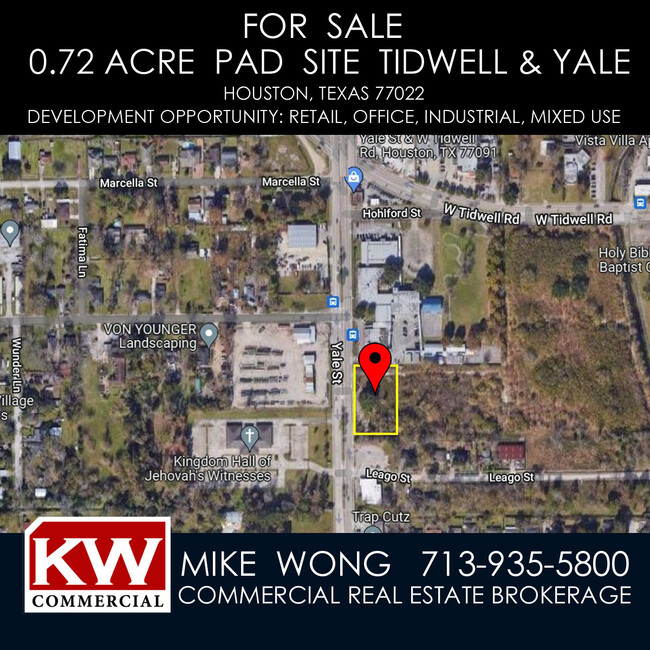
0 Yale St, Houston, TX 77091

Save to a Folder
{{folder.Name}}
{{folder.ListingIds.length}} Properties
{{folder.ListingIds.length}} Property
Create a New Folder
This Property Is For Sale
Property Detail
0 Yale St
Houston-Pasadena-The Woodlands, TX
RES B BLK 1 (EDUCATIONAL & INSTITUTIONAL) HOHL APTS
1248630010002
HARRIS
Commercialacreage
Texas
B and X Area of moderate flood hazard, usually the area between the limits of the 100-year and 500-year floods.
0.73 AC
2025
Northeast Near
2025
Houston
531800
NEARBY LISTINGS FOR SALE OR LEASE
DEMOGRAPHICS near 0 Yale St
1 mile
3 mile
5 mile
2025 Total Population
19,100
143,664
390,459
2030 Population
20,685
154,636
419,391
Pop Growth 2025-2030
+ 8.30%
+ 7.64%
+ 7.41%
Average Age
38
37
37
2025 Total Households
6,877
51,854
145,039
HH Growth 2025-2030
+ 8.59%
+ 7.98%
+ 7.82%
Median Household Inc
$43,775
$68,010
$68,665
Avg Household Size
2.70
2.70
2.60
2025 Avg HH Vehicles
2.00
2.00
2.00
Median Home Value
$264,332
$368,960
$348,259
Median Year Built
1967
1970
1976
Nearby Places
Map Layers
Map Styles
 Street
 Aerial
Layers
 Traffic
 Biking
Places
Listings with unknown addresses are not visible on the map
- Restaurants
- Banks
- Shops
- Fitness
- Groceries
PUBLIC TRANSPORTATION
COMMUTER RAIL
Drive
Walk
Distance
12 min
6.8 mi
AIRPORT
George Bush Intcntl/Houston
Drive
Walk
Distance
George Bush Intcntl/Houston
21 min
14.7 mi
William P Hobby
Drive
Walk
Distance
William P Hobby
32 min
19.6 mi
Freight Ports
Port of Houston
Drive
Walk
Distance
Port of Houston
24 min
15.1 mi
Nearby Properties
Address
Land Use
TOTAL SIZE
Lot Size
Zoning
Address
Land Use
TOTAL SIZE
Lot Size
Zoning
453,456 SF
3.11 AC
Address
Land Use
TOTAL SIZE
Lot Size
Zoning
519,374 SF
6.18 AC
Address
Land Use
TOTAL SIZE
Lot Size
Zoning
563,626 SF
4.71 AC
Address
Land Use
TOTAL SIZE
Lot Size
Zoning
474,326 SF
43.16 AC
Address
Land Use
TOTAL SIZE
Lot Size
Zoning
432,691 SF
3.26 AC
Address
Land Use
TOTAL SIZE
Lot Size
Zoning
261,312 SF
1.81 AC
Address
Land Use
TOTAL SIZE
Lot Size
Zoning
593,265 SF
3.73 AC
Address
Land Use
TOTAL SIZE
Lot Size
Zoning
594,105 SF
43.68 AC
Address
Land Use
TOTAL SIZE
Lot Size
Zoning
379,725 SF
2.84 AC
Address
Land Use
TOTAL SIZE
Lot Size
Zoning
440,577 SF
4.13 AC
Address
Land Use
TOTAL SIZE
Lot Size
Zoning
87,179 SF
4.13 AC
Address
Land Use
TOTAL SIZE
Lot Size
Zoning
322,880 SF
2.61 AC
Address
Land Use
TOTAL SIZE
Lot Size
Zoning
402,433 SF
2.77 AC
Address
Land Use
TOTAL SIZE
Lot Size
Zoning
279,452 SF
5.69 AC
Address
Land Use
TOTAL SIZE
Lot Size
Zoning
198,770 SF
2.10 AC
Address
Land Use
TOTAL SIZE
Lot Size
Zoning
228,804 SF
3.28 AC
Address
Land Use
TOTAL SIZE
Lot Size
Zoning
235,535 SF
1.71 AC
Address
Land Use
TOTAL SIZE
Lot Size
Zoning
276,332 SF
6.05 AC
Address
Land Use
TOTAL SIZE
Lot Size
Zoning
545,628 SF
19.41 AC
Address
Land Use
TOTAL SIZE
Lot Size
Zoning
531,786 SF
17.60 AC
Address
Land Use
TOTAL SIZE
Lot Size
Zoning
197,696 SF
3.06 AC
Address
Land Use
TOTAL SIZE
Lot Size
Zoning
194,990 SF
16.36 AC
Address
Land Use
TOTAL SIZE
Lot Size
Zoning
213,548 SF
16.98 AC
Address
Land Use
TOTAL SIZE
Lot Size
Zoning
160,849 SF
2.14 AC
Address
Land Use
TOTAL SIZE
Lot Size
Zoning
105,268 SF
7.26 AC
Address
Land Use
TOTAL SIZE
Lot Size
Zoning
211,564 SF
1.20 AC
Address
Land Use
TOTAL SIZE
Lot Size
Zoning
200,511 SF
9.48 AC
Address
Land Use
TOTAL SIZE
Lot Size
Zoning
188,582 SF
17.94 AC
Address
Land Use
TOTAL SIZE
Lot Size
Zoning
64,521 SF
3.91 AC
Address
Land Use
TOTAL SIZE
Lot Size
Zoning
139,548 SF
12.71 AC
The World's #1 Commercial Real Estate Marketplace
Connect with us
© 2026 CoStar Group
The information above has been obtained from sources believed reliable. While we do not doubt its accuracy we have not verified it and make no guarantee, warranty or representation about it. It is your responsibility to independently confirm its accuracy and completeness. Any projections, opinions, assumptions, or estimates used are for example only and do not represent the current or future performance of the property. The value of this transaction to you depends on tax and other factors which should be evaluated by your tax, financial, and legal advisors. You and your advisors should conduct a careful, independent investigation of the property to determine to your satisfaction the suitability of the property for your needs.