Property Record
Fork Shoals Rd, , SC
NEARBY LISTINGS FOR SALE OR LEASE
Property Detail
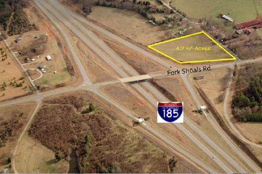
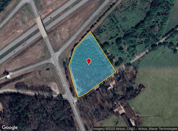
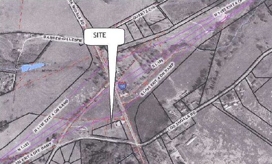
Fork Shoals Rd
Greenville-Anderson-Mauldin, SC
Survey For Quentin O Ball And Bernice W
0583.02-01-016.00
MAP 0583.02
Agriculturalland
Greenville
X
South Carolina
45045C0477E
016.00
2024
4.50 AC
2024
Western Greenville County
003301
Greenville/Spartanburg
DEMOGRAPHICS near Fork Shoals Rd
1 Mile
3 Mile
5 Mile
2024 Total Population
1,780
28,936
81,813
2029 Population
1,973
32,306
90,887
Pop Growth 2024-2029
+ 10.84%
+ 11.65%
+ 11.09%
Average Age
37
39
39
2024 Total Households
643
10,719
31,611
HH Growth 2024-2029
+ 10.89%
+ 11.75%
+ 11.17%
Median Household Inc
$68,047
$78,789
$70,174
Avg Household Size
2.70
2.70
2.50
2024 Avg HH Vehicles
2.00
2.00
2.00
Median Home Value
$216,034
$233,218
$221,514
Median Year Built
2000
2004
1996
Nearby Places
Map Layers
Map Styles
 Street
 Aerial
- Restaurants
- Banks
- Shops
- Fitness
- Groceries
PUBLIC TRANSPORTATION
AIRPORT
Greenville Spartanburg International
DRIVE
WALK
Distance
Greenville Spartanburg International
21 min
17.1 mi
Nearby Properties
Address
Land Use
TOTAL SIZE
Lot Size
Zoning
Address
Land Use
TOTAL SIZE
Lot Size
Zoning
977.33 AC
I1
Address
Land Use
TOTAL SIZE
Lot Size
Zoning
14.13 AC
Address
Land Use
TOTAL SIZE
Lot Size
Zoning
8.97 AC
Address
Land Use
TOTAL SIZE
Lot Size
Zoning
13.90 AC
I1
Address
Land Use
TOTAL SIZE
Lot Size
Zoning
12.85 AC
I1
Address
Land Use
TOTAL SIZE
Lot Size
Zoning
13.36 AC
I1
Address
Land Use
TOTAL SIZE
Lot Size
Zoning
11 AC
I1
Address
Land Use
TOTAL SIZE
Lot Size
Zoning
128.50 AC
I1
Address
Land Use
TOTAL SIZE
Lot Size
Zoning
45.10 AC
I1
Address
Land Use
TOTAL SIZE
Lot Size
Zoning
91.92 AC
I1
Address
Land Use
TOTAL SIZE
Lot Size
Zoning
8.14 AC
I1
Address
Land Use
TOTAL SIZE
Lot Size
Zoning
1,176 SF
126.24 AC
RS
Address
Land Use
TOTAL SIZE
Lot Size
Zoning
75.52 AC
I1
Address
Land Use
TOTAL SIZE
Lot Size
Zoning
59 AC
RS
Address
Land Use
TOTAL SIZE
Lot Size
Zoning
54.61 AC
RS
Address
Land Use
TOTAL SIZE
Lot Size
Zoning
65.40 AC
RS
Address
Land Use
TOTAL SIZE
Lot Size
Zoning
21.33 AC
Address
Land Use
TOTAL SIZE
Lot Size
Zoning
1,145 SF
8.89 AC
R15
Address
Land Use
TOTAL SIZE
Lot Size
Zoning
209.74 AC
I1
Address
Land Use
TOTAL SIZE
Lot Size
Zoning
23.98 AC
I1
Address
Land Use
TOTAL SIZE
Lot Size
Zoning
17.50 AC
I1
Address
Land Use
TOTAL SIZE
Lot Size
Zoning
4.10 AC
I1
Address
Land Use
TOTAL SIZE
Lot Size
Zoning
25.80 AC
I1
Address
Land Use
TOTAL SIZE
Lot Size
Zoning
14.50 AC
I1
Address
Land Use
TOTAL SIZE
Lot Size
Zoning
1,450 SF
8.78 AC
R12
Address
Land Use
TOTAL SIZE
Lot Size
Zoning
3.28 AC
RS
Address
Land Use
TOTAL SIZE
Lot Size
Zoning
85.90 AC
I1
Address
Land Use
TOTAL SIZE
Lot Size
Zoning
59.21 AC
RR1
Address
Land Use
TOTAL SIZE
Lot Size
Zoning
17.37 AC
I1
Address
Land Use
TOTAL SIZE
Lot Size
Zoning
5.20 AC
S1
The World's #1 Commercial Real Estate Marketplace
Connect with us
© 2025 CoStar Group
The information above has been obtained from sources believed reliable. While we do not doubt its accuracy we have not verified it and make no guarantee, warranty or representation about it. It is your responsibility to independently confirm its accuracy and completeness. Any projections, opinions, assumptions, or estimates used are for example only and do not represent the current or future performance of the property. The value of this transaction to you depends on tax and other factors which should be evaluated by your tax, financial, and legal advisors. You and your advisors should conduct a careful, independent investigation of the property to determine to your satisfaction the suitability of the property for your needs.