Property Record
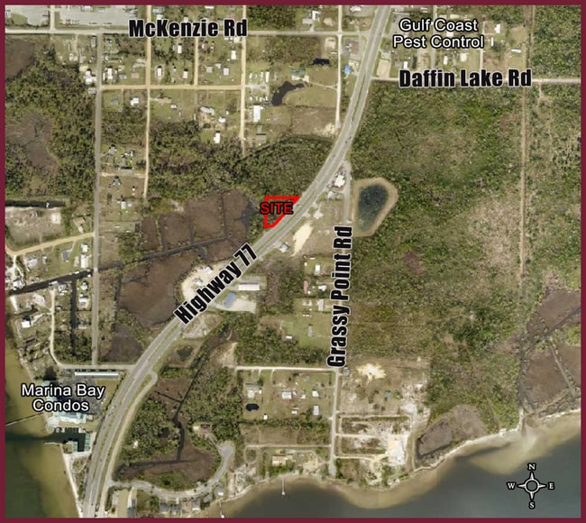
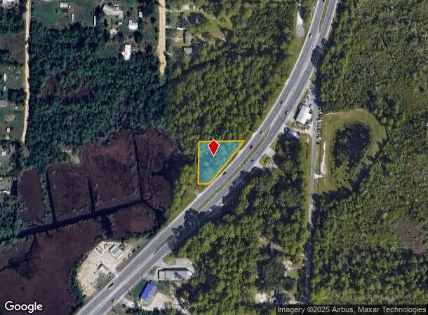
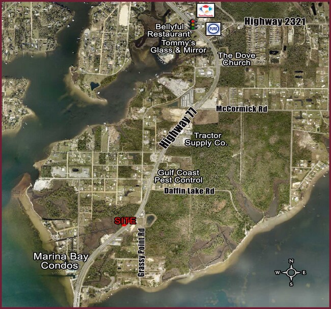
Highway 77, Southport, FL 32409
This Property Is For Sale
NEARBY LISTINGS FOR SALE OR LEASE
Property Detail
Highway 77
Panama City-Panama City Beach, FL
33 2S 14W -86- 101C ST A B PECAN & FIG GROVE CO BEG 132.97 E OF THE NW COR OF LOT 65 FOR POB TH CONT E 252.84 TO THE NEW WLY R/W OF HWY 77 TH RUN SWLY ALONG NEW HWY R/W FOR 273.73 TH W 68.52 N 200.05 TO POB ORB 4603 P 978 LEGAL AFTER R/W TAKEN
08507-000-000
Bay
Commercialacreage
Florida
AE
65
12005C0219J
0.64 AC
2024
Panama City
2025
Other Market Areas
000201
DEMOGRAPHICS near Highway 77
1 Mile
3 Mile
5 Mile
2024 Total Population
642
14,201
35,027
2029 Population
690
14,808
36,819
Pop Growth 2024-2029
+ 7.48%
+ 4.27%
+ 5.12%
Average Age
40
41
40
2024 Total Households
241
5,308
13,177
HH Growth 2024-2029
+ 7.88%
+ 4.77%
+ 5.53%
Median Household Inc
$46,447
$71,101
$71,004
Avg Household Size
2.70
2.60
2.60
2024 Avg HH Vehicles
2.00
2.00
2.00
Median Home Value
$164,285
$252,700
$250,571
Median Year Built
1992
1989
1992
Nearby Places
Map Layers
Map Styles
 Street
 Aerial
- Restaurants
- Banks
- Shops
- Fitness
- Groceries
PUBLIC TRANSPORTATION
AIRPORT
Northwest Florida Beaches International
DRIVE
WALK
Distance
Northwest Florida Beaches International
23 min
15.3 mi
Freight Ports
Port of Panama City
DRIVE
WALK
Distance
Port of Panama City
20 min
9.4 mi
Nearby Properties
Address
Land Use
TOTAL SIZE
Lot Size
Zoning
Address
Land Use
TOTAL SIZE
Lot Size
Zoning
206,758 SF
25.65 AC
SB
Address
Land Use
TOTAL SIZE
Lot Size
Zoning
50,491 SF
6.48 AC
BC14
Address
Land Use
TOTAL SIZE
Lot Size
Zoning
89,000 SF
4.65 AC
BC15
Address
Land Use
TOTAL SIZE
Lot Size
Zoning
135,852 SF
34.90 AC
C5
Address
Land Use
TOTAL SIZE
Lot Size
Zoning
241.76 AC
BC01
Address
Land Use
TOTAL SIZE
Lot Size
Zoning
139,911 SF
37.43 AC
PSP
Address
Land Use
TOTAL SIZE
Lot Size
Zoning
91,484 SF
9.39 AC
RB
Address
Land Use
TOTAL SIZE
Lot Size
Zoning
443.25 AC
UND
Address
Land Use
TOTAL SIZE
Lot Size
Zoning
42,809 SF
0.77 AC
PSP
Address
Land Use
TOTAL SIZE
Lot Size
Zoning
27,485 SF
4.71 AC
BC16
Address
Land Use
TOTAL SIZE
Lot Size
Zoning
2,895 SF
97.83 AC
Address
Land Use
TOTAL SIZE
Lot Size
Zoning
69,020 SF
4.44 AC
BC14
Address
Land Use
TOTAL SIZE
Lot Size
Zoning
133,000 SF
23.94 AC
C5
Address
Land Use
TOTAL SIZE
Lot Size
Zoning
5,940 SF
1.02 AC
SB
Address
Land Use
TOTAL SIZE
Lot Size
Zoning
16,165 SF
1.72 AC
RB
Address
Land Use
TOTAL SIZE
Lot Size
Zoning
24,134 SF
5.17 AC
UND
Address
Land Use
TOTAL SIZE
Lot Size
Zoning
50,754 SF
7.07 AC
MRA
Address
Land Use
TOTAL SIZE
Lot Size
Zoning
6.65 AC
BC13
Address
Land Use
TOTAL SIZE
Lot Size
Zoning
73,792 SF
7.53 AC
PSP
Address
Land Use
TOTAL SIZE
Lot Size
Zoning
31 AC
BC16
Address
Land Use
TOTAL SIZE
Lot Size
Zoning
1,600 SF
14.26 AC
BC15
Address
Land Use
TOTAL SIZE
Lot Size
Zoning
57,580 SF
4.01 AC
BC05
Address
Land Use
TOTAL SIZE
Lot Size
Zoning
5,472 SF
1.84 AC
RB
Address
Land Use
TOTAL SIZE
Lot Size
Zoning
231.05 AC
BC08
Address
Land Use
TOTAL SIZE
Lot Size
Zoning
40 AC
COM
Address
Land Use
TOTAL SIZE
Lot Size
Zoning
3,440 SF
3.60 AC
UND
Address
Land Use
TOTAL SIZE
Lot Size
Zoning
17,169 SF
4.06 AC
BC14
Address
Land Use
TOTAL SIZE
Lot Size
Zoning
61,523 SF
19.60 AC
COM
Address
Land Use
TOTAL SIZE
Lot Size
Zoning
21,936 SF
3.18 AC
MRA
Address
Land Use
TOTAL SIZE
Lot Size
Zoning
6,597 SF
1.65 AC
The World's #1 Commercial Real Estate Marketplace
Connect with us
© 2026 CoStar Group
The information above has been obtained from sources believed reliable. While we do not doubt its accuracy we have not verified it and make no guarantee, warranty or representation about it. It is your responsibility to independently confirm its accuracy and completeness. Any projections, opinions, assumptions, or estimates used are for example only and do not represent the current or future performance of the property. The value of this transaction to you depends on tax and other factors which should be evaluated by your tax, financial, and legal advisors. You and your advisors should conduct a careful, independent investigation of the property to determine to your satisfaction the suitability of the property for your needs.