Property Record
Highway 9, Boiling Springs, SC 29316
NEARBY LISTINGS FOR SALE OR LEASE
Property Detail
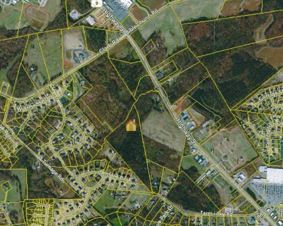
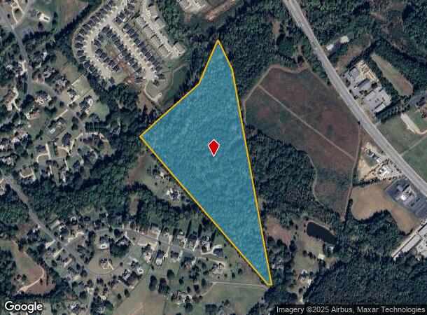
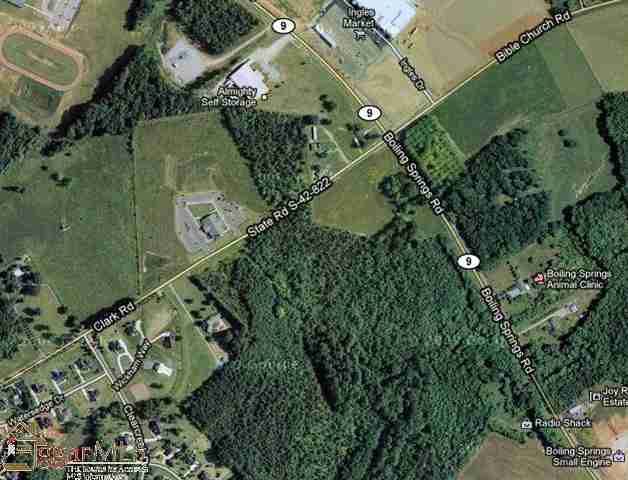
Highway 9
Spartanburg, SC
A J Clement & Lillie E Clement
2-36-00-092.00
W SIDE HIGHWAY 9 & N SIDE FARM LAKE RD DB 111D-249 PB 170-536 HWY RW TAKEN 42.039019 TR 22 DB 132B-
Agriculturalland
Spartanburg
AE
South Carolina
45083C0161D
18.86 AC
2024
North Side/Rt 9 Corridor
2025
Greenville/Spartanburg
022406
DEMOGRAPHICS near Highway 9
1 Mile
3 Mile
5 Mile
2024 Total Population
2,452
28,774
64,310
2029 Population
2,748
32,712
72,970
Pop Growth 2024-2029
+ 12.07%
+ 13.69%
+ 13.47%
Average Age
40
38
38
2024 Total Households
916
10,665
23,782
HH Growth 2024-2029
+ 12.34%
+ 13.91%
+ 13.80%
Median Household Inc
$84,663
$72,506
$66,052
Avg Household Size
2.70
2.60
2.60
2024 Avg HH Vehicles
2.00
2.00
2.00
Median Home Value
$259,073
$207,758
$194,898
Median Year Built
2000
2002
1997
Nearby Places
Map Layers
Map Styles
 Street
 Aerial
- Restaurants
- Banks
- Shops
- Fitness
- Groceries
PUBLIC TRANSPORTATION
COMMUTER RAIL
Spartanburg Amtrak Station (Crescent - Amtrak)
DRIVE
WALK
Distance
Spartanburg Amtrak Station (Crescent - Amtrak)
22 min
9.8 mi
AIRPORT
Greenville Spartanburg International
DRIVE
WALK
Distance
Greenville Spartanburg International
39 min
24.7 mi
Freight Ports
North Charleston Terminal
DRIVE
WALK
Distance
North Charleston Terminal
235 min
204.1 mi
SALE & LEASE HISTORY
LISTING DATE
SALE/LEASE

Jun 12, 2017
For Sale
Apr 14, 2017
For Sale
Nearby Properties
Address
Land Use
TOTAL SIZE
Lot Size
Zoning
Address
Land Use
TOTAL SIZE
Lot Size
Zoning
22,955 SF
5.05 AC
Address
Land Use
TOTAL SIZE
Lot Size
Zoning
3,406 SF
13.10 AC
Address
Land Use
TOTAL SIZE
Lot Size
Zoning
7,218 SF
16 AC
Address
Land Use
TOTAL SIZE
Lot Size
Zoning
3,412 SF
21.60 AC
Address
Land Use
TOTAL SIZE
Lot Size
Zoning
5,034 SF
17.60 AC
Address
Land Use
TOTAL SIZE
Lot Size
Zoning
24,738 SF
34.52 AC
Address
Land Use
TOTAL SIZE
Lot Size
Zoning
62,000 SF
10.17 AC
Address
Land Use
TOTAL SIZE
Lot Size
Zoning
3,112 SF
20.17 AC
Address
Land Use
TOTAL SIZE
Lot Size
Zoning
7,000 SF
3 AC
Address
Land Use
TOTAL SIZE
Lot Size
Zoning
184,015 SF
19.23 AC
Address
Land Use
TOTAL SIZE
Lot Size
Zoning
42,657 SF
11.57 AC
Address
Land Use
TOTAL SIZE
Lot Size
Zoning
641,891 SF
16.26 AC
Address
Land Use
TOTAL SIZE
Lot Size
Zoning
108,060 SF
2.95 AC
Address
Land Use
TOTAL SIZE
Lot Size
Zoning
Address
Land Use
TOTAL SIZE
Lot Size
Zoning
5,236 SF
0.65 AC
Address
Land Use
TOTAL SIZE
Lot Size
Zoning
6,695 SF
0.30 AC
Address
Land Use
TOTAL SIZE
Lot Size
Zoning
4,426 SF
Address
Land Use
TOTAL SIZE
Lot Size
Zoning
172,332 SF
15.01 AC
Address
Land Use
TOTAL SIZE
Lot Size
Zoning
4,283 SF
0.50 AC
Address
Land Use
TOTAL SIZE
Lot Size
Zoning
5,263 SF
0.77 AC
Address
Land Use
TOTAL SIZE
Lot Size
Zoning
Address
Land Use
TOTAL SIZE
Lot Size
Zoning
3,683 SF
0.21 AC
Address
Land Use
TOTAL SIZE
Lot Size
Zoning
2,877 SF
0.55 AC
Address
Land Use
TOTAL SIZE
Lot Size
Zoning
4,398 SF
0.25 AC
Address
Land Use
TOTAL SIZE
Lot Size
Zoning
4,260 SF
0.66 AC
Address
Land Use
TOTAL SIZE
Lot Size
Zoning
5,267 SF
1.18 AC
Address
Land Use
TOTAL SIZE
Lot Size
Zoning
4,091 SF
0.28 AC
Address
Land Use
TOTAL SIZE
Lot Size
Zoning
5,190 SF
0.93 AC
Address
Land Use
TOTAL SIZE
Lot Size
Zoning
Address
Land Use
TOTAL SIZE
Lot Size
Zoning
6,432 SF
0.63 AC
The World's #1 Commercial Real Estate Marketplace
Connect with us
© 2025 CoStar Group
The information above has been obtained from sources believed reliable. While we do not doubt its accuracy we have not verified it and make no guarantee, warranty or representation about it. It is your responsibility to independently confirm its accuracy and completeness. Any projections, opinions, assumptions, or estimates used are for example only and do not represent the current or future performance of the property. The value of this transaction to you depends on tax and other factors which should be evaluated by your tax, financial, and legal advisors. You and your advisors should conduct a careful, independent investigation of the property to determine to your satisfaction the suitability of the property for your needs.