Property Record
3485 N Highway 25, Travelers Rest, SC 29690
NEARBY LISTINGS FOR SALE OR LEASE
-
-
View all Travelers Rest listings for sale on LoopNet.com
Property Detail
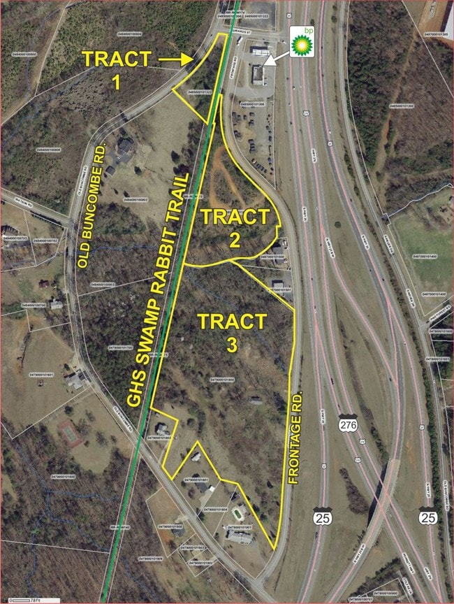
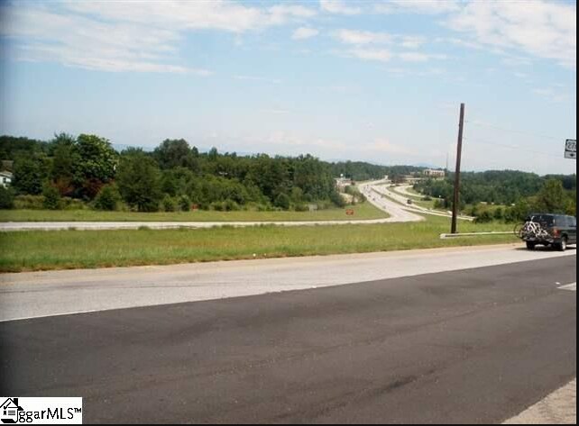
3485 N Highway 25
Greenville-Anderson-Mauldin, SC
MAP 0485.00
0485.00-01-013.01
Greenville
Commercialnec
South Carolina
AE
013.01
45045C0304E
3.92 AC
2024
Travelers Rest
2024
Greenville/Spartanburg
004004
DEMOGRAPHICS near 3485 N Highway 25
1 Mile
3 Mile
5 Mile
2024 Total Population
3,252
21,334
54,817
2029 Population
3,577
23,431
60,370
Pop Growth 2024-2029
+ 9.99%
+ 9.83%
+ 10.13%
Average Age
40
40
40
2024 Total Households
1,222
7,939
21,350
HH Growth 2024-2029
+ 10.39%
+ 10.43%
+ 10.43%
Median Household Inc
$66,477
$62,914
$57,609
Avg Household Size
2.50
2.40
2.40
2024 Avg HH Vehicles
2.00
2.00
2.00
Median Home Value
$313,953
$262,677
$237,981
Median Year Built
1999
1995
1988
Nearby Places
- Restaurants
- Banks
- Shops
- Fitness
- Groceries
PUBLIC TRANSPORTATION
AIRPORT
Greenville Spartanburg International
DRIVE
WALK
Distance
Greenville Spartanburg International
44 min
24.5 mi
Asheville Regional
DRIVE
WALK
Distance
Asheville Regional
38 min
30.0 mi
Freight Ports
North Charleston Terminal
DRIVE
WALK
Distance
North Charleston Terminal
259 min
223.5 mi
SALE & LEASE HISTORY
LISTING DATE
SALE/LEASE

Sep 24, 2016
For Sale
Nearby Properties
Address
Land Use
TOTAL SIZE
Lot Size
Zoning
Address
Land Use
TOTAL SIZE
Lot Size
Zoning
9,066 SF
120.93 AC
UNZONED
Address
Land Use
TOTAL SIZE
Lot Size
Zoning
548.08 AC
UNZONED
Address
Land Use
TOTAL SIZE
Lot Size
Zoning
1.87 AC
UNZONED
Address
Land Use
TOTAL SIZE
Lot Size
Zoning
272.60 AC
UNZONED
Address
Land Use
TOTAL SIZE
Lot Size
Zoning
173.71 AC
UNZONED
Address
Land Use
TOTAL SIZE
Lot Size
Zoning
27.03 AC
UNZONED
Address
Land Use
TOTAL SIZE
Lot Size
Zoning
2.06 AC
UNZONED
Address
Land Use
TOTAL SIZE
Lot Size
Zoning
2,448 SF
191.56 AC
UNZONED
Address
Land Use
TOTAL SIZE
Lot Size
Zoning
24.17 AC
UNZONED
Address
Land Use
TOTAL SIZE
Lot Size
Zoning
40.70 AC
Address
Land Use
TOTAL SIZE
Lot Size
Zoning
3,488 SF
29.40 AC
UNZONED
Address
Land Use
TOTAL SIZE
Lot Size
Zoning
5.32 AC
UNZONED
Address
Land Use
TOTAL SIZE
Lot Size
Zoning
9.50 AC
UNZONED
Address
Land Use
TOTAL SIZE
Lot Size
Zoning
9.78 AC
UNZONED
Address
Land Use
TOTAL SIZE
Lot Size
Zoning
1.51 AC
UNZONED
Address
Land Use
TOTAL SIZE
Lot Size
Zoning
20.40 AC
UNZONED
Address
Land Use
TOTAL SIZE
Lot Size
Zoning
Address
Land Use
TOTAL SIZE
Lot Size
Zoning
0.54 AC
UNZONED
Address
Land Use
TOTAL SIZE
Lot Size
Zoning
18.30 AC
UNZONED
Address
Land Use
TOTAL SIZE
Lot Size
Zoning
0.90 AC
UNZONED
Address
Land Use
TOTAL SIZE
Lot Size
Zoning
0.90 AC
UNZONED
Address
Land Use
TOTAL SIZE
Lot Size
Zoning
14 AC
UNZONED
Address
Land Use
TOTAL SIZE
Lot Size
Zoning
8.80 AC
UNZONED
Address
Land Use
TOTAL SIZE
Lot Size
Zoning
6 AC
UNZONED
Address
Land Use
TOTAL SIZE
Lot Size
Zoning
10.07 AC
UNZONED
Address
Land Use
TOTAL SIZE
Lot Size
Zoning
1.51 AC
UNZONED
Address
Land Use
TOTAL SIZE
Lot Size
Zoning
848 SF
12.94 AC
UNZONED
Address
Land Use
TOTAL SIZE
Lot Size
Zoning
6.40 AC
UNZONED
Address
Land Use
TOTAL SIZE
Lot Size
Zoning
7.50 AC
UNZONED
Address
Land Use
TOTAL SIZE
Lot Size
Zoning
7.10 AC
UNZONED
The World's #1 Commercial Real Estate Marketplace
Connect with us
© 2025 CoStar Group
The information above has been obtained from sources believed reliable. While we do not doubt its accuracy we have not verified it and make no guarantee, warranty or representation about it. It is your responsibility to independently confirm its accuracy and completeness. Any projections, opinions, assumptions, or estimates used are for example only and do not represent the current or future performance of the property. The value of this transaction to you depends on tax and other factors which should be evaluated by your tax, financial, and legal advisors. You and your advisors should conduct a careful, independent investigation of the property to determine to your satisfaction the suitability of the property for your needs.