Property Record
Carey Rd, Kinston, NC 28504
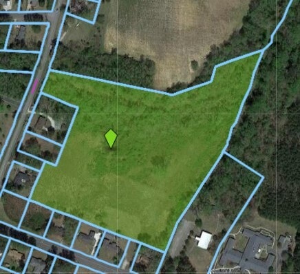
Property Detail
Carey Rd
Kinston, NC
CAREY ROAD LOT 4 CAREY RD
451610364225
LENOIR
Vacantlandnec
North Carolina
RA6
4
B and X Area of moderate flood hazard, usually the area between the limits of the 100-year and 500-year floods.
0.50 AC
2025
North Carolina Southeast Area
2025
Other Market Areas
011001
NEARBY LISTINGS FOR SALE OR LEASE
DEMOGRAPHICS near Carey Rd
1 mile
3 mile
5 mile
2025 Total Population
2,967
17,596
29,095
2030 Population
2,950
17,718
29,557
Pop Growth 2025-2030
(0.57%)
+ 0.69%
+ 1.59%
Average Age
45
44
43
2025 Total Households
1,253
7,474
12,471
HH Growth 2025-2030
(0.56%)
+ 0.76%
+ 1.68%
Median Household Inc
$48,737
$44,123
$41,155
Avg Household Size
2.10
2.20
2.20
2025 Avg HH Vehicles
1.00
2.00
2.00
Median Home Value
$151,190
$126,542
$127,767
Median Year Built
1976
1970
1972
Nearby Places
Map Layers
Map Styles
 Street
 Aerial
Layers
 Traffic
 Biking
Places
Listings with unknown addresses are not visible on the map
- Restaurants
- Banks
- Shops
- Fitness
- Groceries
PUBLIC TRANSPORTATION
AIRPORT
Pitt-Greenville
Drive
Walk
Distance
Pitt-Greenville
46 min
32.2 mi
Albert J Ellis
Drive
Walk
Distance
Albert J Ellis
71 min
39.3 mi
Coastal Carolina Regional
Drive
Walk
Distance
Coastal Carolina Regional
61 min
42.4 mi
Nearby Properties
Address
Land Use
TOTAL SIZE
Lot Size
Zoning
Address
Land Use
TOTAL SIZE
Lot Size
Zoning
274,824 SF
54.92 AC
OI
Address
Land Use
TOTAL SIZE
Lot Size
Zoning
22,420 SF
762.37 AC
RA6
Address
Land Use
TOTAL SIZE
Lot Size
Zoning
25,376 SF
953.68 AC
RA12
Address
Land Use
TOTAL SIZE
Lot Size
Zoning
159,064 SF
Address
Land Use
TOTAL SIZE
Lot Size
Zoning
65,704 SF
278.06 AC
RA20
Address
Land Use
TOTAL SIZE
Lot Size
Zoning
114,876 SF
64.24 AC
RA6
Address
Land Use
TOTAL SIZE
Lot Size
Zoning
185,181 SF
12.24 AC
SC
Address
Land Use
TOTAL SIZE
Lot Size
Zoning
150,941 SF
20 AC
I1
Address
Land Use
TOTAL SIZE
Lot Size
Zoning
107,460 SF
17.70 AC
I2
Address
Land Use
TOTAL SIZE
Lot Size
Zoning
247,376 SF
99.63 AC
I1
Address
Land Use
TOTAL SIZE
Lot Size
Zoning
64,008 SF
24 AC
I1
Address
Land Use
TOTAL SIZE
Lot Size
Zoning
191,518 SF
20.71 AC
SC
Address
Land Use
TOTAL SIZE
Lot Size
Zoning
15,858 SF
54.75 AC
I1
Address
Land Use
TOTAL SIZE
Lot Size
Zoning
214,740 SF
Address
Land Use
TOTAL SIZE
Lot Size
Zoning
156,784 SF
63.12 AC
I1
Address
Land Use
TOTAL SIZE
Lot Size
Zoning
7,700 SF
16.52 AC
RA6
Address
Land Use
TOTAL SIZE
Lot Size
Zoning
278,576 SF
30.06 AC
I1
Address
Land Use
TOTAL SIZE
Lot Size
Zoning
234.71 AC
I1
Address
Land Use
TOTAL SIZE
Lot Size
Zoning
254,440 SF
51.94 AC
I1
Address
Land Use
TOTAL SIZE
Lot Size
Zoning
145,364 SF
76.38 AC
I1
Address
Land Use
TOTAL SIZE
Lot Size
Zoning
20,748 SF
33.22 AC
B1
Address
Land Use
TOTAL SIZE
Lot Size
Zoning
119,634 SF
1.86 AC
B2
Address
Land Use
TOTAL SIZE
Lot Size
Zoning
5,664 SF
407.13 AC
RA6
Address
Land Use
TOTAL SIZE
Lot Size
Zoning
28,034 SF
278.73 AC
RA12
Address
Land Use
TOTAL SIZE
Lot Size
Zoning
101,200 SF
30.89 AC
Address
Land Use
TOTAL SIZE
Lot Size
Zoning
117,120 SF
8.12 AC
I1
Address
Land Use
TOTAL SIZE
Lot Size
Zoning
123,220 SF
8.99 AC
I1
Address
Land Use
TOTAL SIZE
Lot Size
Zoning
18,213 SF
159.12 AC
OI
Address
Land Use
TOTAL SIZE
Lot Size
Zoning
424,443 SF
104.04 AC
SC
Address
Land Use
TOTAL SIZE
Lot Size
Zoning
44,800 SF
9.75 AC
O&I
The World's #1 Commercial Real Estate Marketplace
Connect with us
© 2026 CoStar Group
The information above has been obtained from sources believed reliable. While we do not doubt its accuracy we have not verified it and make no guarantee, warranty or representation about it. It is your responsibility to independently confirm its accuracy and completeness. Any projections, opinions, assumptions, or estimates used are for example only and do not represent the current or future performance of the property. The value of this transaction to you depends on tax and other factors which should be evaluated by your tax, financial, and legal advisors. You and your advisors should conduct a careful, independent investigation of the property to determine to your satisfaction the suitability of the property for your needs.