Property Record
202 Belwood Rd, Calhoun, GA 30701
This Property Is For Sale
NEARBY LISTINGS FOR SALE OR LEASE
Property Detail
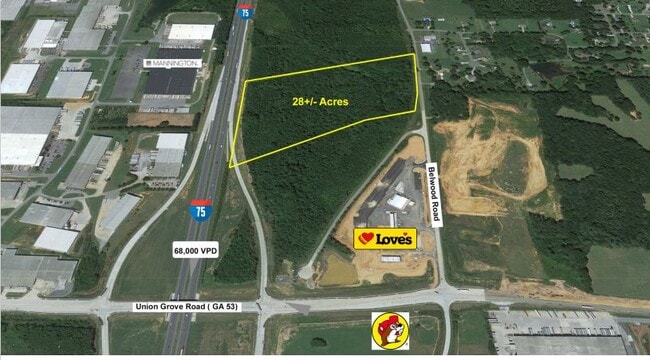
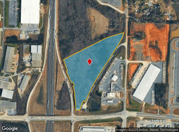
202 Belwood Rd
CG58-059
LL 182 & 209
Privatepreserveopenspacevacantlandforestlandconservation
Gordon
X
Georgia
13015C0050H
20.49 AC
2024
Georgia Northwest
2024
Other Market Areas
970500
Calhoun, GA
DEMOGRAPHICS near 202 Belwood Rd
1 Mile
3 Mile
5 Mile
2024 Total Population
740
8,254
29,742
2029 Population
792
8,782
31,844
Pop Growth 2024-2029
+ 7.03%
+ 6.40%
+ 7.07%
Average Age
42
39
39
2024 Total Households
284
3,075
11,065
HH Growth 2024-2029
+ 7.04%
+ 6.15%
+ 6.84%
Median Household Inc
$51,739
$44,215
$51,616
Avg Household Size
2.60
2.60
2.60
2024 Avg HH Vehicles
2.00
2.00
2.00
Median Home Value
$198,076
$161,992
$190,439
Median Year Built
1993
1983
1988
Nearby Places
Map Layers
Map Styles
 Street
 Aerial
- Restaurants
- Banks
- Shops
- Fitness
- Groceries
Nearby Properties
Address
Land Use
TOTAL SIZE
Lot Size
Zoning
Address
Land Use
TOTAL SIZE
Lot Size
Zoning
675,935 SF
63.15 AC
I-2
Address
Land Use
TOTAL SIZE
Lot Size
Zoning
740,998 SF
55.39 AC
IND-G
Address
Land Use
TOTAL SIZE
Lot Size
Zoning
445,290 SF
37.89 AC
I-2
Address
Land Use
TOTAL SIZE
Lot Size
Zoning
63.15 AC
I-2
Address
Land Use
TOTAL SIZE
Lot Size
Zoning
63.15 AC
I-2
Address
Land Use
TOTAL SIZE
Lot Size
Zoning
394,200 SF
32.57 AC
Address
Land Use
TOTAL SIZE
Lot Size
Zoning
403,152 SF
8.33 AC
Address
Land Use
TOTAL SIZE
Lot Size
Zoning
740,750 SF
30.22 AC
IND-G
Address
Land Use
TOTAL SIZE
Lot Size
Zoning
474,912 SF
54.83 AC
IND-G
Address
Land Use
TOTAL SIZE
Lot Size
Zoning
408,600 SF
38.92 AC
I-2
Address
Land Use
TOTAL SIZE
Lot Size
Zoning
549,997 SF
138.47 AC
IND-G
Address
Land Use
TOTAL SIZE
Lot Size
Zoning
454,680 SF
5.23 AC
IND-G
Address
Land Use
TOTAL SIZE
Lot Size
Zoning
192,578 SF
25.47 AC
C-N
Address
Land Use
TOTAL SIZE
Lot Size
Zoning
89,298 SF
25.68 AC
I-2
Address
Land Use
TOTAL SIZE
Lot Size
Zoning
860,400 SF
19.85 AC
IND-G
Address
Land Use
TOTAL SIZE
Lot Size
Zoning
96,647 SF
35.06 AC
I-2
Address
Land Use
TOTAL SIZE
Lot Size
Zoning
2,870 SF
11.02 AC
PRD
Address
Land Use
TOTAL SIZE
Lot Size
Zoning
50,676 SF
19.74 AC
C-2
Address
Land Use
TOTAL SIZE
Lot Size
Zoning
2,899 SF
12 AC
Address
Land Use
TOTAL SIZE
Lot Size
Zoning
3,360 SF
25.27 AC
RC-1
Address
Land Use
TOTAL SIZE
Lot Size
Zoning
88,000 SF
8.87 AC
IND-G
Address
Land Use
TOTAL SIZE
Lot Size
Zoning
128,740 SF
42.95 AC
IND-G
Address
Land Use
TOTAL SIZE
Lot Size
Zoning
6,956 SF
7 AC
R-2
Address
Land Use
TOTAL SIZE
Lot Size
Zoning
281,810 SF
22.74 AC
IND-G
Address
Land Use
TOTAL SIZE
Lot Size
Zoning
207,900 SF
13.43 AC
IND-G
Address
Land Use
TOTAL SIZE
Lot Size
Zoning
150.97 AC
I-2
Address
Land Use
TOTAL SIZE
Lot Size
Zoning
225,000 SF
14.68 AC
IND-G
Address
Land Use
TOTAL SIZE
Lot Size
Zoning
16,424 SF
5.73 AC
MU
Address
Land Use
TOTAL SIZE
Lot Size
Zoning
67,800 SF
10.53 AC
I-1
Address
Land Use
TOTAL SIZE
Lot Size
Zoning
259,964 SF
78.21 AC
IND-G
The World's #1 Commercial Real Estate Marketplace
Connect with us
© 2025 CoStar Group
The information above has been obtained from sources believed reliable. While we do not doubt its accuracy we have not verified it and make no guarantee, warranty or representation about it. It is your responsibility to independently confirm its accuracy and completeness. Any projections, opinions, assumptions, or estimates used are for example only and do not represent the current or future performance of the property. The value of this transaction to you depends on tax and other factors which should be evaluated by your tax, financial, and legal advisors. You and your advisors should conduct a careful, independent investigation of the property to determine to your satisfaction the suitability of the property for your needs.