Property Record
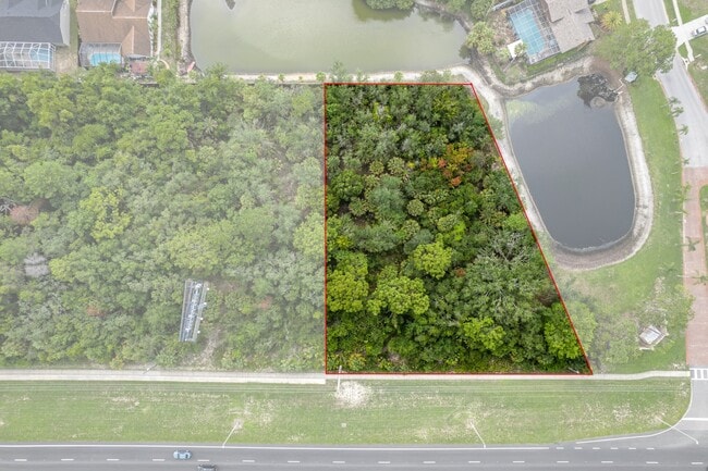
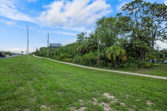
10835 Hilltop Dr, New Port Richey, FL 34654

This Property Is For Sale
Property Detail
10835 Hilltop Dr
Tampa-St. Petersburg-Clearwater, FL
COM NW COR OF SE1/4 OF NW1/4 TH S00DG 33 00W 1169.67 FT TH N89DG 36 15E 680.39 FT TO WLY R/W US 19 TH N23DG 46 00E 1078.69 FT FOR POB TH N66DG 14 00W 250.00 FT TH N23DG 46 00E 112.27 FT TH N88DG 24 00E 276.68 FT TH S23DG 46 00W 230.80 FT TO POB AKA P
06-24-17-0000-00300-0020
PASCO
Commercialacreage
Florida
C2
2
A Areas with a 1% annual chance of flooding and a 26% chance of flooding over the life of a 30-year mortgage.
0.98 AC
2024
Pasco County
2026
Tampa/St Petersburg
030101
NEARBY LISTINGS FOR SALE OR LEASE
DEMOGRAPHICS near 10835 Hilltop Dr
1 mile
3 mile
5 mile
2025 Total Population
3,385
19,569
57,719
2030 Population
3,763
21,729
64,211
Pop Growth 2025-2030
+ 11.17%
+ 11.04%
+ 11.25%
Average Age
53
48
49
2025 Total Households
1,527
8,406
25,493
HH Growth 2025-2030
+ 10.94%
+ 10.86%
+ 10.95%
Median Household Inc
$67,061
$63,316
$60,272
Avg Household Size
2.20
2.30
2.20
2025 Avg HH Vehicles
2.00
2.00
2.00
Median Home Value
$283,488
$295,631
$297,486
Median Year Built
1995
1988
1988
Nearby Places
Map Layers
Map Styles
 Street
 Aerial
Layers
 Traffic
 Biking
Places
Listings with unknown addresses are not visible on the map
- Restaurants
- Banks
- Shops
- Fitness
- Groceries
Nearby Properties
Address
Land Use
TOTAL SIZE
Lot Size
Zoning
Address
Land Use
TOTAL SIZE
Lot Size
Zoning
217,451 SF
19.40 AC
Address
Land Use
TOTAL SIZE
Lot Size
Zoning
232,408 SF
24.40 AC
Address
Land Use
TOTAL SIZE
Lot Size
Zoning
108,275 SF
1.79 AC
Address
Land Use
TOTAL SIZE
Lot Size
Zoning
115,496 SF
12.20 AC
Address
Land Use
TOTAL SIZE
Lot Size
Zoning
115,277 SF
8.40 AC
Address
Land Use
TOTAL SIZE
Lot Size
Zoning
155,070 SF
10.69 AC
Address
Land Use
TOTAL SIZE
Lot Size
Zoning
89,263 SF
3.54 AC
Address
Land Use
TOTAL SIZE
Lot Size
Zoning
40,066 SF
1.99 AC
Address
Land Use
TOTAL SIZE
Lot Size
Zoning
80,053 SF
5.43 AC
C2
Address
Land Use
TOTAL SIZE
Lot Size
Zoning
54,136 SF
8.20 AC
Address
Land Use
TOTAL SIZE
Lot Size
Zoning
53,492 SF
40 AC
AC
Address
Land Use
TOTAL SIZE
Lot Size
Zoning
60,109 SF
2.77 AC
C3
Address
Land Use
TOTAL SIZE
Lot Size
Zoning
83,815 SF
12.10 AC
Address
Land Use
TOTAL SIZE
Lot Size
Zoning
3,500 SF
50.01 AC
AC
Address
Land Use
TOTAL SIZE
Lot Size
Zoning
47,910 SF
0.68 AC
Address
Land Use
TOTAL SIZE
Lot Size
Zoning
8,760 SF
2.29 AC
Address
Land Use
TOTAL SIZE
Lot Size
Zoning
45,146 SF
3.21 AC
Address
Land Use
TOTAL SIZE
Lot Size
Zoning
39,024 SF
5.55 AC
MF1
Address
Land Use
TOTAL SIZE
Lot Size
Zoning
16,438 SF
4.16 AC
Address
Land Use
TOTAL SIZE
Lot Size
Zoning
15,441 SF
1.90 AC
Address
Land Use
TOTAL SIZE
Lot Size
Zoning
6,474 SF
3.26 AC
Address
Land Use
TOTAL SIZE
Lot Size
Zoning
64,000 SF
4.24 AC
I2
Address
Land Use
TOTAL SIZE
Lot Size
Zoning
11,268 SF
1.11 AC
Address
Land Use
TOTAL SIZE
Lot Size
Zoning
3,328 SF
1.29 AC
Address
Land Use
TOTAL SIZE
Lot Size
Zoning
42,050 SF
3.47 AC
C2
Address
Land Use
TOTAL SIZE
Lot Size
Zoning
37,635 SF
1.66 AC
C3
Address
Land Use
TOTAL SIZE
Lot Size
Zoning
159.30 AC
Address
Land Use
TOTAL SIZE
Lot Size
Zoning
9,186 SF
1.37 AC
Address
Land Use
TOTAL SIZE
Lot Size
Zoning
11,618 SF
Address
Land Use
TOTAL SIZE
Lot Size
Zoning
44,691 SF
3.12 AC
The World's #1 Commercial Real Estate Marketplace
Connect with us
© 2026 CoStar Group
The information above has been obtained from sources believed reliable. While we do not doubt its accuracy we have not verified it and make no guarantee, warranty or representation about it. It is your responsibility to independently confirm its accuracy and completeness. Any projections, opinions, assumptions, or estimates used are for example only and do not represent the current or future performance of the property. The value of this transaction to you depends on tax and other factors which should be evaluated by your tax, financial, and legal advisors. You and your advisors should conduct a careful, independent investigation of the property to determine to your satisfaction the suitability of the property for your needs.