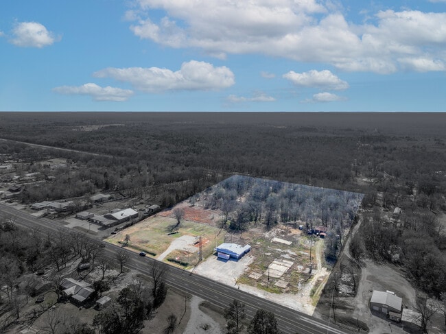
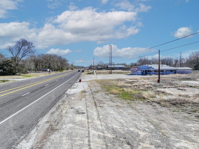
Property Record
Highway 80, Mineola, TX 75773
Current Lease Availabilities
Property Detail
Highway 80
R12961
ABS 0658; YARBROUGH S; TRACT 243; 8.0 ACRES
Commercialnec
WOOD
B and X Area of moderate flood hazard, usually the area between the limits of the 100-year and 500-year floods.
Texas
2025
8 AC
2025
Texas East Area
950800
Other Market Areas
4,314 SF
NEARBY LISTINGS FOR SALE OR LEASE
-
-
View all Mineola listings for lease on LoopNet.com
DEMOGRAPHICS near Highway 80
1 mile
3 mile
5 mile
2025 Total Population
495
5,477
11,370
2030 Population
525
5,859
12,157
Pop Growth 2025-2030
+ 6.06%
+ 6.97%
+ 6.92%
Average Age
43
43
44
2025 Total Households
187
2,086
4,425
HH Growth 2025-2030
+ 6.42%
+ 7.00%
+ 6.87%
Median Household Inc
$56,052
$54,792
$54,569
Avg Household Size
2.50
2.50
2.50
2025 Avg HH Vehicles
2.00
2.00
2.00
Median Home Value
$249,107
$236,801
$240,185
Median Year Built
1990
1988
1987
Nearby Places
Map Layers
Map Styles
 Street
 Aerial
Layers
 Traffic
 Biking
Places
Listings with unknown addresses are not visible on the map
- Restaurants
- Banks
- Shops
- Fitness
- Groceries
PUBLIC TRANSPORTATION
COMMUTER RAIL
Mineola (Texas Eagle - Amtrak)
Drive
Walk
Distance
Mineola (Texas Eagle - Amtrak)
4 min
3.0 mi
AIRPORT
Tyler Pounds Regional
Drive
Walk
Distance
Tyler Pounds Regional
37 min
28.4 mi
Freight Ports
Port of Shreveport
Drive
Walk
Distance
Port of Shreveport
142 min
127.1 mi
Nearby Properties
Address
Land Use
TOTAL SIZE
Lot Size
Zoning
Address
Land Use
TOTAL SIZE
Lot Size
Zoning
55,614 SF
3.49 AC
Address
Land Use
TOTAL SIZE
Lot Size
Zoning
106,466 SF
52.34 AC
Address
Land Use
TOTAL SIZE
Lot Size
Zoning
31,880 SF
12.57 AC
Address
Land Use
TOTAL SIZE
Lot Size
Zoning
2,319 SF
588.60 AC
Address
Land Use
TOTAL SIZE
Lot Size
Zoning
7,844 SF
62.98 AC
Address
Land Use
TOTAL SIZE
Lot Size
Zoning
6,083 SF
122.96 AC
Address
Land Use
TOTAL SIZE
Lot Size
Zoning
4,703 SF
255.77 AC
Address
Land Use
TOTAL SIZE
Lot Size
Zoning
8,675 SF
159.35 AC
Address
Land Use
TOTAL SIZE
Lot Size
Zoning
15,466 SF
1.60 AC
Address
Land Use
TOTAL SIZE
Lot Size
Zoning
54,489 SF
3.19 AC
Address
Land Use
TOTAL SIZE
Lot Size
Zoning
18,583 SF
2.08 AC
Address
Land Use
TOTAL SIZE
Lot Size
Zoning
10,396 SF
0.69 AC
Address
Land Use
TOTAL SIZE
Lot Size
Zoning
11,405 SF
65.30 AC
Address
Land Use
TOTAL SIZE
Lot Size
Zoning
19,593 SF
2.65 AC
Address
Land Use
TOTAL SIZE
Lot Size
Zoning
24,096 SF
0.71 AC
Address
Land Use
TOTAL SIZE
Lot Size
Zoning
20,188 SF
0.42 AC
Address
Land Use
TOTAL SIZE
Lot Size
Zoning
7,900 SF
20 AC
Address
Land Use
TOTAL SIZE
Lot Size
Zoning
13,200 SF
21.39 AC
Address
Land Use
TOTAL SIZE
Lot Size
Zoning
10,062 SF
0.59 AC
Address
Land Use
TOTAL SIZE
Lot Size
Zoning
13,624 SF
4.33 AC
Address
Land Use
TOTAL SIZE
Lot Size
Zoning
1,720 SF
163.80 AC
Address
Land Use
TOTAL SIZE
Lot Size
Zoning
27,121 SF
7.57 AC
Address
Land Use
TOTAL SIZE
Lot Size
Zoning
15,252 SF
2.39 AC
Address
Land Use
TOTAL SIZE
Lot Size
Zoning
600 SF
175.51 AC
Address
Land Use
TOTAL SIZE
Lot Size
Zoning
9,200 SF
0.60 AC
Address
Land Use
TOTAL SIZE
Lot Size
Zoning
2,400 SF
77.09 AC
Address
Land Use
TOTAL SIZE
Lot Size
Zoning
17,721 SF
0.52 AC
Address
Land Use
TOTAL SIZE
Lot Size
Zoning
3,634 SF
1.52 AC
Address
Land Use
TOTAL SIZE
Lot Size
Zoning
27,724 SF
1.74 AC
Address
Land Use
TOTAL SIZE
Lot Size
Zoning
2,938 SF
45.75 AC
The World's #1 Commercial Real Estate Marketplace
Connect with us
© 2026 CoStar Group
The information above has been obtained from sources believed reliable. While we do not doubt its accuracy we have not verified it and make no guarantee, warranty or representation about it. It is your responsibility to independently confirm its accuracy and completeness. Any projections, opinions, assumptions, or estimates used are for example only and do not represent the current or future performance of the property. The value of this transaction to you depends on tax and other factors which should be evaluated by your tax, financial, and legal advisors. You and your advisors should conduct a careful, independent investigation of the property to determine to your satisfaction the suitability of the property for your needs.