Property Record
Central Rd, Apple Valley, CA 92307
NEARBY LISTINGS FOR SALE OR LEASE
Property Detail
Central Rd
Riverside-San Bernardino-Ontario, CA
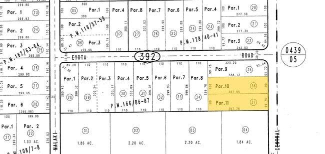
Parcel Map No 11188
3087-392-36
PARCEL MAP 11188 PARCEL 11 BOOK 166 PAGE 86
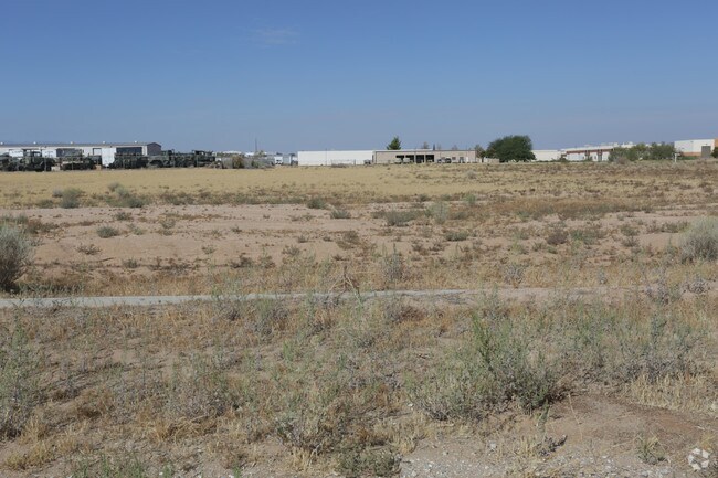
Vacantlandnec
San Bernardino
D
California
06071C6510H
0.82 AC
2024
Mojave River Valley
2025
Inland Empire (California)
009714
DEMOGRAPHICS near Central Rd
1 Mile
3 Mile
5 Mile
2024 Total Population
4,185
34,246
70,274
2029 Population
4,255
34,813
71,434
Pop Growth 2024-2029
+ 1.67%
+ 1.66%
+ 1.65%
Average Age
37
37
39
2024 Total Households
1,445
10,890
23,765
HH Growth 2024-2029
+ 1.59%
+ 1.65%
+ 1.63%
Median Household Inc
$42,251
$58,382
$64,932
Avg Household Size
2.90
3.10
2.90
2024 Avg HH Vehicles
2.00
2.00
2.00
Median Home Value
$208,305
$304,067
$351,134
Median Year Built
1984
1984
1986
Nearby Places
Map Layers
Map Styles
 Street
 Aerial
- Restaurants
- Banks
- Shops
- Fitness
- Groceries
PUBLIC TRANSPORTATION
COMMUTER RAIL
Victorville Amtrak (Southwest Chief - Amtrak)
DRIVE
WALK
Distance
Victorville Amtrak (Southwest Chief - Amtrak)
12 min
8.6 mi
Freight Ports
Port of Long Beach
DRIVE
WALK
Distance
Port of Long Beach
127 min
103.9 mi
SALE & LEASE HISTORY
LISTING DATE
SALE/LEASE

Sep 24, 2016
For Sale
Nearby Properties
Address
Land Use
TOTAL SIZE
Lot Size
Zoning
Address
Land Use
TOTAL SIZE
Lot Size
Zoning
116,365 SF
8.93 AC
Address
Land Use
TOTAL SIZE
Lot Size
Zoning
75,280 SF
4.07 AC
Address
Land Use
TOTAL SIZE
Lot Size
Zoning
14,739 SF
1.38 AC
Address
Land Use
TOTAL SIZE
Lot Size
Zoning
16,804 SF
1.80 AC
Address
Land Use
TOTAL SIZE
Lot Size
Zoning
35,178 SF
3.44 AC
Address
Land Use
TOTAL SIZE
Lot Size
Zoning
22,488 SF
3.05 AC
Address
Land Use
TOTAL SIZE
Lot Size
Zoning
86,148 SF
5.38 AC
Address
Land Use
TOTAL SIZE
Lot Size
Zoning
4,998 SF
2.76 AC
Address
Land Use
TOTAL SIZE
Lot Size
Zoning
2,618 SF
6.77 AC
Address
Land Use
TOTAL SIZE
Lot Size
Zoning
55,415 SF
2.91 AC
Address
Land Use
TOTAL SIZE
Lot Size
Zoning
53,972 SF
4.80 AC
Address
Land Use
TOTAL SIZE
Lot Size
Zoning
3,500 SF
0.51 AC
Address
Land Use
TOTAL SIZE
Lot Size
Zoning
22,700 SF
6.19 AC
Address
Land Use
TOTAL SIZE
Lot Size
Zoning
60.38 AC
Address
Land Use
TOTAL SIZE
Lot Size
Zoning
37,521 SF
24.52 AC
Address
Land Use
TOTAL SIZE
Lot Size
Zoning
9,545 SF
0.52 AC
Address
Land Use
TOTAL SIZE
Lot Size
Zoning
8,970 SF
0.78 AC
Address
Land Use
TOTAL SIZE
Lot Size
Zoning
15,885 SF
4.38 AC
Address
Land Use
TOTAL SIZE
Lot Size
Zoning
870 SF
0.79 AC
Address
Land Use
TOTAL SIZE
Lot Size
Zoning
31,524 SF
2.94 AC
Address
Land Use
TOTAL SIZE
Lot Size
Zoning
15,740 SF
4.23 AC
Address
Land Use
TOTAL SIZE
Lot Size
Zoning
12,320 SF
0.92 AC
Address
Land Use
TOTAL SIZE
Lot Size
Zoning
2,247 SF
0.73 AC
Address
Land Use
TOTAL SIZE
Lot Size
Zoning
21,050 SF
1.45 AC
Address
Land Use
TOTAL SIZE
Lot Size
Zoning
28,200 SF
2.50 AC
Address
Land Use
TOTAL SIZE
Lot Size
Zoning
9,239 SF
1.28 AC
Address
Land Use
TOTAL SIZE
Lot Size
Zoning
12,505 SF
4.84 AC
Address
Land Use
TOTAL SIZE
Lot Size
Zoning
19,590 SF
2.19 AC
Address
Land Use
TOTAL SIZE
Lot Size
Zoning
19,140 SF
1.84 AC
Address
Land Use
TOTAL SIZE
Lot Size
Zoning
12,483 SF
1.80 AC
The World's #1 Commercial Real Estate Marketplace
Connect with us
© 2026 CoStar Group
The information above has been obtained from sources believed reliable. While we do not doubt its accuracy we have not verified it and make no guarantee, warranty or representation about it. It is your responsibility to independently confirm its accuracy and completeness. Any projections, opinions, assumptions, or estimates used are for example only and do not represent the current or future performance of the property. The value of this transaction to you depends on tax and other factors which should be evaluated by your tax, financial, and legal advisors. You and your advisors should conduct a careful, independent investigation of the property to determine to your satisfaction the suitability of the property for your needs.