Property Record
Cr1855 Cr 122, Burnet, TX 78611

Property Detail
Cr1855 Cr 122
47933
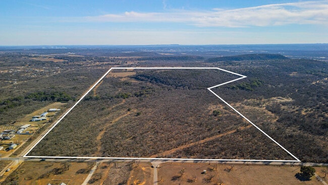
ABS A0058 JEFFERSON BARTON, TRACT PT OF 8, 152.65 ACRES
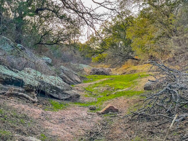
Agriculturalland
BURNET
AE The base floodplain where base flood elevations are provided. AE Zones are now used on new format FIRMs instead of A1-A30 Zones.
Texas
2025
152.65 AC
2025
Marble Falls
960200
Other Market Areas
NEARBY LISTINGS FOR SALE OR LEASE
DEMOGRAPHICS near Cr1855 Cr 122
1 mile
3 mile
5 mile
2025 Total Population
209
1,614
9,104
2030 Population
222
1,704
9,883
Pop Growth 2025-2030
+ 6.22%
+ 5.58%
+ 8.56%
Average Age
44
45
42
2025 Total Households
83
621
3,529
HH Growth 2025-2030
+ 6.02%
+ 5.31%
+ 8.53%
Median Household Inc
$107,812
$104,487
$70,208
Avg Household Size
2.60
2.50
2.50
2025 Avg HH Vehicles
2.00
2.00
2.00
Median Home Value
$344,117
$490,908
$353,744
Median Year Built
1987
1992
1999
Nearby Places
Map Layers
Map Styles
 Street
 Aerial
Layers
 Traffic
 Biking
Places
Listings with unknown addresses are not visible on the map
- Restaurants
- Banks
- Shops
- Fitness
- Groceries
SALE & LEASE HISTORY
LISTING DATE
SALE/LEASE

Jan 24, 2025
For Sale
Nearby Properties
Address
Land Use
TOTAL SIZE
Lot Size
Zoning
Address
Land Use
TOTAL SIZE
Lot Size
Zoning
54,059 SF
20.69 AC
Address
Land Use
TOTAL SIZE
Lot Size
Zoning
202,505 SF
22.65 AC
Address
Land Use
TOTAL SIZE
Lot Size
Zoning
73,721 SF
9.30 AC
Address
Land Use
TOTAL SIZE
Lot Size
Zoning
110,433 SF
17.07 AC
Address
Land Use
TOTAL SIZE
Lot Size
Zoning
39,159 SF
7 AC
Address
Land Use
TOTAL SIZE
Lot Size
Zoning
58,040 SF
16.71 AC
Address
Land Use
TOTAL SIZE
Lot Size
Zoning
728 SF
138.68 AC
Address
Land Use
TOTAL SIZE
Lot Size
Zoning
17,063 SF
419.34 AC
Address
Land Use
TOTAL SIZE
Lot Size
Zoning
Address
Land Use
TOTAL SIZE
Lot Size
Zoning
30,522 SF
2.50 AC
Address
Land Use
TOTAL SIZE
Lot Size
Zoning
44,050 SF
2.36 AC
Address
Land Use
TOTAL SIZE
Lot Size
Zoning
6,000 SF
5.80 AC
Address
Land Use
TOTAL SIZE
Lot Size
Zoning
16,938 SF
12.09 AC
Address
Land Use
TOTAL SIZE
Lot Size
Zoning
10,900 SF
1.82 AC
Address
Land Use
TOTAL SIZE
Lot Size
Zoning
29,376 SF
10.76 AC
Address
Land Use
TOTAL SIZE
Lot Size
Zoning
212.65 AC
Address
Land Use
TOTAL SIZE
Lot Size
Zoning
30,300 SF
4 AC
Address
Land Use
TOTAL SIZE
Lot Size
Zoning
6,120 SF
10.05 AC
Address
Land Use
TOTAL SIZE
Lot Size
Zoning
21.15 AC
Address
Land Use
TOTAL SIZE
Lot Size
Zoning
27,553 SF
5 AC
Address
Land Use
TOTAL SIZE
Lot Size
Zoning
60,596 SF
1.65 AC
Address
Land Use
TOTAL SIZE
Lot Size
Zoning
87,271 SF
2 AC
Address
Land Use
TOTAL SIZE
Lot Size
Zoning
17,500 SF
2.24 AC
Address
Land Use
TOTAL SIZE
Lot Size
Zoning
16,475 SF
1.56 AC
Address
Land Use
TOTAL SIZE
Lot Size
Zoning
40,106 SF
5.02 AC
Address
Land Use
TOTAL SIZE
Lot Size
Zoning
30,300 SF
1.89 AC
Address
Land Use
TOTAL SIZE
Lot Size
Zoning
9,518 SF
12 AC
Address
Land Use
TOTAL SIZE
Lot Size
Zoning
29,805 SF
3.25 AC
Address
Land Use
TOTAL SIZE
Lot Size
Zoning
5,800 SF
7.19 AC
Address
Land Use
TOTAL SIZE
Lot Size
Zoning
9,265 SF
1.68 AC
The World's #1 Commercial Real Estate Marketplace
Connect with us
© 2026 CoStar Group
The information above has been obtained from sources believed reliable. While we do not doubt its accuracy we have not verified it and make no guarantee, warranty or representation about it. It is your responsibility to independently confirm its accuracy and completeness. Any projections, opinions, assumptions, or estimates used are for example only and do not represent the current or future performance of the property. The value of this transaction to you depends on tax and other factors which should be evaluated by your tax, financial, and legal advisors. You and your advisors should conduct a careful, independent investigation of the property to determine to your satisfaction the suitability of the property for your needs.