Property Record
0 Mount Nebo Rd, Pittsburgh, PA 15237

Save to a Folder
{{folder.Name}}
{{folder.ListingIds.length}} Properties
{{folder.ListingIds.length}} Property
Create a New Folder
This Property Is For Sale
Property Detail
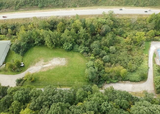
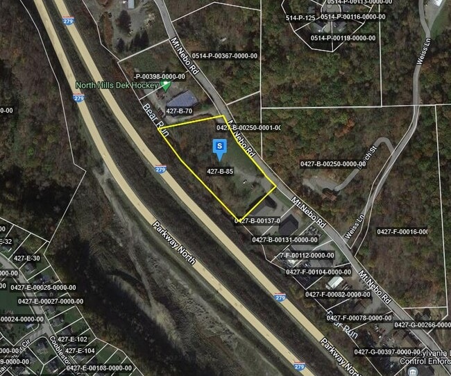
0 Mount Nebo Rd
Pittsburgh, PA
VIEWPOINT PLAN LOT 3 = 466.86 FRONTING WITH 11 TOTAL BEARINGS
0427-B-00085-0000-00
ALLEGHENY
Commercialacreage
Pennsylvania
AE The base floodplain where base flood elevations are provided. AE Zones are now used on new format FIRMs instead of A1-A30 Zones.
85
2026
3.59 AC
2026
North Pittsburgh/Rte 19
429400
Pittsburgh
NEARBY LISTINGS FOR SALE OR LEASE
DEMOGRAPHICS near 0 Mount Nebo Rd
1 mile
3 mile
5 mile
2025 Total Population
4,176
47,763
139,099
2030 Population
4,067
46,666
136,211
Pop Growth 2025-2030
(2.61%)
(2.30%)
(2.08%)
Average Age
39
43
43
2025 Total Households
1,559
20,454
60,204
HH Growth 2025-2030
(2.69%)
(2.42%)
(2.17%)
Median Household Inc
$174,871
$96,443
$88,788
Avg Household Size
2.60
2.30
2.20
2025 Avg HH Vehicles
2.00
2.00
2.00
Median Home Value
$519,171
$309,236
$282,562
Median Year Built
1999
1964
1962
Nearby Places
Map Layers
Map Styles
 Street
 Aerial
Layers
 Traffic
 Biking
Places
Listings with unknown addresses are not visible on the map
- Restaurants
- Banks
- Shops
- Fitness
- Groceries
PUBLIC TRANSPORTATION
COMMUTER RAIL
Pittsburgh Amtrak Station (Capitol Limited - Amtrak, Pennsylvanian - Amtrak)
Drive
Walk
Distance
Pittsburgh Amtrak Station (Capitol Limited - Amtrak, Pennsylvanian - Amtrak)
16 min
9.4 mi
AIRPORT
Pittsburgh International
Drive
Walk
Distance
Pittsburgh International
27 min
13.2 mi
Freight Ports
Port of Toledo
Drive
Walk
Distance
Port of Toledo
255 min
223.9 mi
Nearby Properties
Address
Land Use
TOTAL SIZE
Lot Size
Zoning
Address
Land Use
TOTAL SIZE
Lot Size
Zoning
33.85 AC
Address
Land Use
TOTAL SIZE
Lot Size
Zoning
9.71 AC
Address
Land Use
TOTAL SIZE
Lot Size
Zoning
24.53 AC
Address
Land Use
TOTAL SIZE
Lot Size
Zoning
25.70 AC
Address
Land Use
TOTAL SIZE
Lot Size
Zoning
45.85 AC
Address
Land Use
TOTAL SIZE
Lot Size
Zoning
13.03 AC
Address
Land Use
TOTAL SIZE
Lot Size
Zoning
88.84 AC
Address
Land Use
TOTAL SIZE
Lot Size
Zoning
6.52 AC
Address
Land Use
TOTAL SIZE
Lot Size
Zoning
46.07 AC
Address
Land Use
TOTAL SIZE
Lot Size
Zoning
2.20 AC
Address
Land Use
TOTAL SIZE
Lot Size
Zoning
Address
Land Use
TOTAL SIZE
Lot Size
Zoning
1,381 SF
7.53 AC
Address
Land Use
TOTAL SIZE
Lot Size
Zoning
Address
Land Use
TOTAL SIZE
Lot Size
Zoning
48.63 AC
Address
Land Use
TOTAL SIZE
Lot Size
Zoning
2,198 SF
4.05 AC
Address
Land Use
TOTAL SIZE
Lot Size
Zoning
Address
Land Use
TOTAL SIZE
Lot Size
Zoning
8.69 AC
Address
Land Use
TOTAL SIZE
Lot Size
Zoning
45.06 AC
Address
Land Use
TOTAL SIZE
Lot Size
Zoning
12.43 AC
Address
Land Use
TOTAL SIZE
Lot Size
Zoning
12.18 AC
Address
Land Use
TOTAL SIZE
Lot Size
Zoning
Address
Land Use
TOTAL SIZE
Lot Size
Zoning
11.79 AC
Address
Land Use
TOTAL SIZE
Lot Size
Zoning
Address
Land Use
TOTAL SIZE
Lot Size
Zoning
11.98 AC
Address
Land Use
TOTAL SIZE
Lot Size
Zoning
15.68 AC
Address
Land Use
TOTAL SIZE
Lot Size
Zoning
124.84 AC
Address
Land Use
TOTAL SIZE
Lot Size
Zoning
Address
Land Use
TOTAL SIZE
Lot Size
Zoning
Address
Land Use
TOTAL SIZE
Lot Size
Zoning
Address
Land Use
TOTAL SIZE
Lot Size
Zoning
The World's #1 Commercial Real Estate Marketplace
Connect with us
© 2026 CoStar Group
The information above has been obtained from sources believed reliable. While we do not doubt its accuracy we have not verified it and make no guarantee, warranty or representation about it. It is your responsibility to independently confirm its accuracy and completeness. Any projections, opinions, assumptions, or estimates used are for example only and do not represent the current or future performance of the property. The value of this transaction to you depends on tax and other factors which should be evaluated by your tax, financial, and legal advisors. You and your advisors should conduct a careful, independent investigation of the property to determine to your satisfaction the suitability of the property for your needs.