Property Record
Settingdown Rd, Cumming, GA 30041


NEARBY LISTINGS FOR SALE OR LEASE
-
-
-
-
No Photo
-
-
-
View all Cumming listings for sale on LoopNet.com
Property Detail
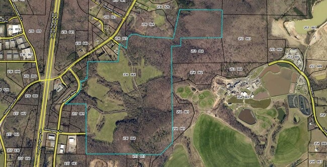
Settingdown Rd
Atlanta-Sandy Springs-Roswell, GA
Chestatee Crossroads Llc
236-064
Forsyth
Ruralagriculturalresidence
Georgia
AE
204.87 AC
13117C0064G
N Fulton/Forsyth County
896 SF
Atlanta
DEMOGRAPHICS near Settingdown Rd
1 Mile
3 Mile
5 Mile
2024 Total Population
576
23,736
59,435
2029 Population
667
27,614
70,152
Pop Growth 2024-2029
+ 15.80%
+ 16.34%
+ 18.03%
Average Age
38
37
39
2024 Total Households
211
7,847
20,540
HH Growth 2024-2029
+ 15.64%
+ 16.41%
+ 18.16%
Median Household Inc
$108,088
$106,076
$99,703
Avg Household Size
2.70
3.00
2.80
2024 Avg HH Vehicles
2.00
2.00
2.00
Median Home Value
$356,716
$375,107
$376,048
Median Year Built
2010
2005
2001
Nearby Places
Map Layers
Map Styles
 Street
 Aerial
- Restaurants
- Banks
- Shops
- Fitness
- Groceries
SALE & LEASE HISTORY
LISTING DATE
SALE/LEASE

Sep 24, 2016
For Sale
Nearby Properties
Address
Land Use
TOTAL SIZE
Lot Size
Zoning
Address
Land Use
TOTAL SIZE
Lot Size
Zoning
57,180 SF
61.71 AC
RES6
Address
Land Use
TOTAL SIZE
Lot Size
Zoning
28.74 AC
MP
Address
Land Use
TOTAL SIZE
Lot Size
Zoning
413,484 SF
127.99 AC
A1
Address
Land Use
TOTAL SIZE
Lot Size
Zoning
98,743 SF
12.61 AC
CBD
Address
Land Use
TOTAL SIZE
Lot Size
Zoning
50,875 SF
420.29 AC
A1
Address
Land Use
TOTAL SIZE
Lot Size
Zoning
19.21 AC
M1
Address
Land Use
TOTAL SIZE
Lot Size
Zoning
152,668 SF
41.92 AC
CBD
Address
Land Use
TOTAL SIZE
Lot Size
Zoning
59,534 SF
16.93 AC
CBD
Address
Land Use
TOTAL SIZE
Lot Size
Zoning
74,796 SF
9.92 AC
CBD
Address
Land Use
TOTAL SIZE
Lot Size
Zoning
192,550 SF
21.11 AC
CBD
Address
Land Use
TOTAL SIZE
Lot Size
Zoning
80,956 SF
6.07 AC
CBD
Address
Land Use
TOTAL SIZE
Lot Size
Zoning
229.24 AC
M1
Address
Land Use
TOTAL SIZE
Lot Size
Zoning
80,497 SF
9.22 AC
CBD
Address
Land Use
TOTAL SIZE
Lot Size
Zoning
12,217 SF
3.85 AC
CBD
Address
Land Use
TOTAL SIZE
Lot Size
Zoning
39,251 SF
109.39 AC
A1
Address
Land Use
TOTAL SIZE
Lot Size
Zoning
3.90 AC
M1
Address
Land Use
TOTAL SIZE
Lot Size
Zoning
54,186 SF
26.64 AC
CBD
Address
Land Use
TOTAL SIZE
Lot Size
Zoning
54,090 SF
8.70 AC
CBD
Address
Land Use
TOTAL SIZE
Lot Size
Zoning
69,200 SF
5.61 AC
CBD
Address
Land Use
TOTAL SIZE
Lot Size
Zoning
2,955 SF
5.88 AC
NS
Address
Land Use
TOTAL SIZE
Lot Size
Zoning
138.66 AC
A1
Address
Land Use
TOTAL SIZE
Lot Size
Zoning
33,608 SF
3.34 AC
HB
Address
Land Use
TOTAL SIZE
Lot Size
Zoning
40,092 SF
3.35 AC
M1
Address
Land Use
TOTAL SIZE
Lot Size
Zoning
3,060 SF
8.47 AC
M1
Address
Land Use
TOTAL SIZE
Lot Size
Zoning
1,595 SF
16.76 AC
CBD
Address
Land Use
TOTAL SIZE
Lot Size
Zoning
41,486 SF
6.11 AC
M1
Address
Land Use
TOTAL SIZE
Lot Size
Zoning
47,205 SF
40.23 AC
A1
Address
Land Use
TOTAL SIZE
Lot Size
Zoning
47,453 SF
6.87 AC
CBD
Address
Land Use
TOTAL SIZE
Lot Size
Zoning
31,423 SF
4.30 AC
CBD
Address
Land Use
TOTAL SIZE
Lot Size
Zoning
46,540 SF
11.10 AC
CBD
The World's #1 Commercial Real Estate Marketplace
Connect with us
© 2026 CoStar Group
The information above has been obtained from sources believed reliable. While we do not doubt its accuracy we have not verified it and make no guarantee, warranty or representation about it. It is your responsibility to independently confirm its accuracy and completeness. Any projections, opinions, assumptions, or estimates used are for example only and do not represent the current or future performance of the property. The value of this transaction to you depends on tax and other factors which should be evaluated by your tax, financial, and legal advisors. You and your advisors should conduct a careful, independent investigation of the property to determine to your satisfaction the suitability of the property for your needs.