Property Record
5271 Wayne Rd, White Lake, MI 48383

Property Detail
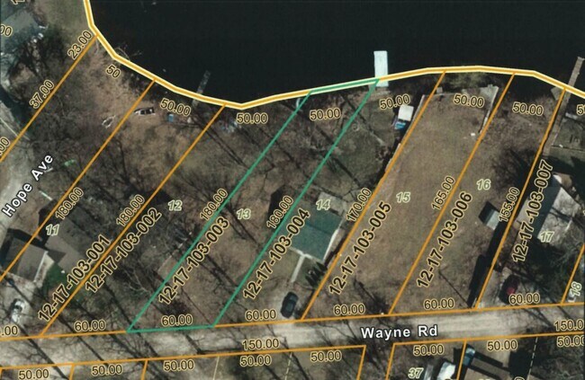
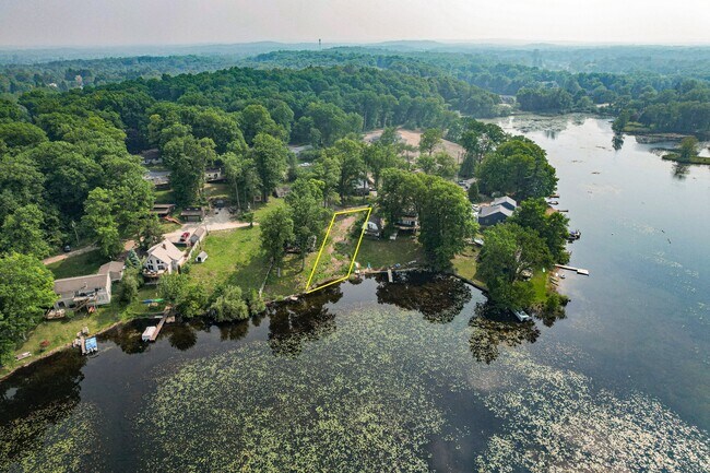
5271 Wayne Rd
Detroit-Warren-Dearborn, MI
T3N, R8E, SEC 17 RAYWOOD PARK LOT 13
12-17-103-003
OAKLAND
Residentialacreage
Michigan
R1D
13
AE The base floodplain where base flood elevations are provided. AE Zones are now used on new format FIRMs instead of A1-A30 Zones.
0.22 AC
2024
St Clair & Lapeer Counties
2025
Detroit
130200
NEARBY LISTINGS FOR SALE OR LEASE
DEMOGRAPHICS near 5271 Wayne Rd
1 mile
3 mile
5 mile
2025 Total Population
2,049
18,753
51,463
2030 Population
2,089
19,183
52,726
Pop Growth 2025-2030
+ 1.95%
+ 2.29%
+ 2.45%
Average Age
42
42
43
2025 Total Households
783
7,235
19,717
HH Growth 2025-2030
+ 2.04%
+ 2.42%
+ 2.58%
Median Household Inc
$103,472
$92,932
$99,005
Avg Household Size
2.60
2.60
2.60
2025 Avg HH Vehicles
2.00
2.00
2.00
Median Home Value
$314,216
$319,268
$347,073
Median Year Built
1982
1980
1983
Nearby Places
Map Layers
Map Styles
 Street
 Aerial
Transit
 Traffic
 Biking
Places
Listings with unknown addresses are not visible on the map
- Restaurants
- Banks
- Shops
- Fitness
- Groceries
PUBLIC TRANSPORTATION
AIRPORT
Bishop International
Drive
Walk
Distance
Bishop International
56 min
37.6 mi
Freight Ports
Port of Toledo
Drive
Walk
Distance
Port of Toledo
110 min
85.0 mi
SALE & LEASE HISTORY
LISTING DATE
SALE/LEASE

Jun 17, 2025
For Sale
Nearby Properties
Address
Land Use
TOTAL SIZE
Lot Size
Zoning
Address
Land Use
TOTAL SIZE
Lot Size
Zoning
9,452 SF
Address
Land Use
TOTAL SIZE
Lot Size
Zoning
4,260 SF
101.34 AC
MM
Address
Land Use
TOTAL SIZE
Lot Size
Zoning
207,282 SF
55.01 AC
BI
Address
Land Use
TOTAL SIZE
Lot Size
Zoning
119,755 SF
14.03 AC
Address
Land Use
TOTAL SIZE
Lot Size
Zoning
71,627 SF
13 AC
BV
Address
Land Use
TOTAL SIZE
Lot Size
Zoning
42,467 SF
13.70 AC
Address
Land Use
TOTAL SIZE
Lot Size
Zoning
46,500 SF
5.86 AC
BI
Address
Land Use
TOTAL SIZE
Lot Size
Zoning
34,854 SF
5.28 AC
AI
Address
Land Use
TOTAL SIZE
Lot Size
Zoning
65,345 SF
5.69 AC
GB
Address
Land Use
TOTAL SIZE
Lot Size
Zoning
88,540 SF
9.07 AC
PB
Address
Land Use
TOTAL SIZE
Lot Size
Zoning
103,525 SF
8.33 AC
PB
Address
Land Use
TOTAL SIZE
Lot Size
Zoning
45,644 SF
7.74 AC
BI
Address
Land Use
TOTAL SIZE
Lot Size
Zoning
38,846 SF
6.78 AC
BI
Address
Land Use
TOTAL SIZE
Lot Size
Zoning
24,370 SF
4.86 AC
BI
Address
Land Use
TOTAL SIZE
Lot Size
Zoning
23,300 SF
3.99 AC
BI
Address
Land Use
TOTAL SIZE
Lot Size
Zoning
58,677 SF
16.70 AC
II
Address
Land Use
TOTAL SIZE
Lot Size
Zoning
25,432 SF
4.53 AC
AI
Address
Land Use
TOTAL SIZE
Lot Size
Zoning
291.23 AC
ROS
Address
Land Use
TOTAL SIZE
Lot Size
Zoning
29,295 SF
15.15 AC
AI
Address
Land Use
TOTAL SIZE
Lot Size
Zoning
12,463 SF
4.73 AC
Address
Land Use
TOTAL SIZE
Lot Size
Zoning
15.74 AC
MM
Address
Land Use
TOTAL SIZE
Lot Size
Zoning
19,097 SF
6.04 AC
GB
Address
Land Use
TOTAL SIZE
Lot Size
Zoning
11,400 SF
1.44 AC
Address
Land Use
TOTAL SIZE
Lot Size
Zoning
12,000 SF
1.43 AC
BI
Address
Land Use
TOTAL SIZE
Lot Size
Zoning
24,027 SF
2.10 AC
BV
Address
Land Use
TOTAL SIZE
Lot Size
Zoning
20,700 SF
Address
Land Use
TOTAL SIZE
Lot Size
Zoning
12,601 SF
2.54 AC
BI
Address
Land Use
TOTAL SIZE
Lot Size
Zoning
29,143 SF
9.62 AC
BI
Address
Land Use
TOTAL SIZE
Lot Size
Zoning
10,859 SF
2.70 AC
GB
Address
Land Use
TOTAL SIZE
Lot Size
Zoning
18,769 SF
2.29 AC
BI
The World's #1 Commercial Real Estate Marketplace
Connect with us
© 2026 CoStar Group
The information above has been obtained from sources believed reliable. While we do not doubt its accuracy we have not verified it and make no guarantee, warranty or representation about it. It is your responsibility to independently confirm its accuracy and completeness. Any projections, opinions, assumptions, or estimates used are for example only and do not represent the current or future performance of the property. The value of this transaction to you depends on tax and other factors which should be evaluated by your tax, financial, and legal advisors. You and your advisors should conduct a careful, independent investigation of the property to determine to your satisfaction the suitability of the property for your needs.