Property Record
1825 Cliff Maus Dr, Corpus Christi, TX 78416
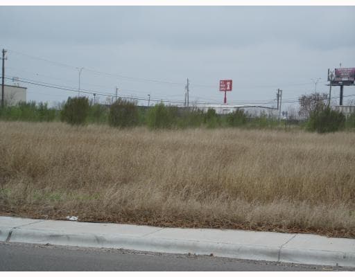
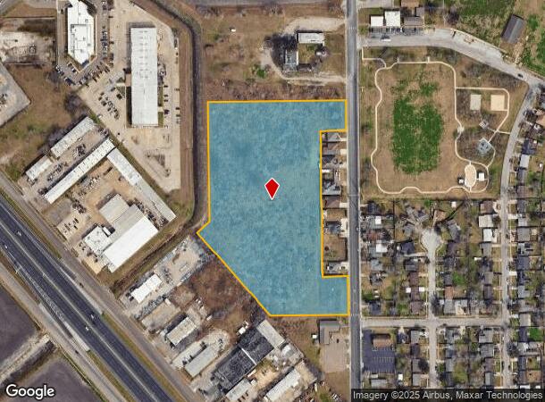
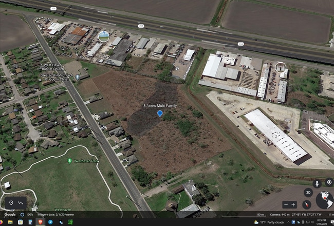
This Property Is For Sale
NEARBY LISTINGS FOR SALE OR LEASE
Property Detail
1825 Cliff Maus Dr
Corpus Christi, TX
Gugenheim And Cohn
240134
GUGENHEIM & COHN FARM LTS 8.66 ACS OUT OF GABRIEL PART TR 2-A
Farms
Nueces
AE
Texas
48355C0315G
2a
2024
8.60 AC
2025
West Side
001703
Corpus Christi
DEMOGRAPHICS near 1825 Cliff Maus Dr
1 Mile
3 Mile
5 Mile
2024 Total Population
5,130
49,862
123,783
2029 Population
5,056
49,144
122,598
Pop Growth 2024-2029
(1.44%)
(1.44%)
(0.96%)
Average Age
39
38
39
2024 Total Households
1,715
16,970
44,855
HH Growth 2024-2029
(1.57%)
(1.56%)
(0.96%)
Median Household Inc
$38,042
$39,441
$43,758
Avg Household Size
2.80
2.80
2.60
2024 Avg HH Vehicles
2.00
2.00
2.00
Median Home Value
$67,028
$74,798
$113,340
Median Year Built
1974
1960
1963
Nearby Places
- Restaurants
- Banks
- Shops
- Fitness
- Groceries
PUBLIC TRANSPORTATION
AIRPORT
Corpus Christi International
DRIVE
WALK
Distance
Corpus Christi International
10 min
5.6 mi
Freight Ports
Port of Corpus Christi
DRIVE
WALK
Distance
Port of Corpus Christi
11 min
6.1 mi
Nearby Properties
Address
Land Use
TOTAL SIZE
Lot Size
Zoning
Address
Land Use
TOTAL SIZE
Lot Size
Zoning
382,448 SF
14.98 AC
Address
Land Use
TOTAL SIZE
Lot Size
Zoning
251,402 SF
7.17 AC
Address
Land Use
TOTAL SIZE
Lot Size
Zoning
278,919 SF
39.27 AC
R1B
Address
Land Use
TOTAL SIZE
Lot Size
Zoning
105,979 SF
25 AC
I2SP92
Address
Land Use
TOTAL SIZE
Lot Size
Zoning
74,247 SF
6.39 AC
Address
Land Use
TOTAL SIZE
Lot Size
Zoning
85,871 SF
18.68 AC
R1B
Address
Land Use
TOTAL SIZE
Lot Size
Zoning
11,109 SF
76.58 AC
R1B
Address
Land Use
TOTAL SIZE
Lot Size
Zoning
89,537 SF
11.35 AC
R1B
Address
Land Use
TOTAL SIZE
Lot Size
Zoning
83,835 SF
19.14 AC
Address
Land Use
TOTAL SIZE
Lot Size
Zoning
101,912 SF
13.89 AC
I-2
Address
Land Use
TOTAL SIZE
Lot Size
Zoning
74,261 SF
4.44 AC
R1B
Address
Land Use
TOTAL SIZE
Lot Size
Zoning
105.49 AC
R1B
Address
Land Use
TOTAL SIZE
Lot Size
Zoning
42,984 SF
5.20 AC
Address
Land Use
TOTAL SIZE
Lot Size
Zoning
129,210 SF
11.63 AC
R1B
Address
Land Use
TOTAL SIZE
Lot Size
Zoning
140,058 SF
90.04 AC
I2
Address
Land Use
TOTAL SIZE
Lot Size
Zoning
95,658 SF
21.87 AC
I2
Address
Land Use
TOTAL SIZE
Lot Size
Zoning
83,499 SF
5.38 AC
III
Address
Land Use
TOTAL SIZE
Lot Size
Zoning
95,860 SF
10.80 AC
R1B
Address
Land Use
TOTAL SIZE
Lot Size
Zoning
25,998 SF
31.72 AC
R1B
Address
Land Use
TOTAL SIZE
Lot Size
Zoning
28,410 SF
8.55 AC
Address
Land Use
TOTAL SIZE
Lot Size
Zoning
97,550 SF
9.53 AC
B-4
Address
Land Use
TOTAL SIZE
Lot Size
Zoning
57,600 SF
9.97 AC
I2
Address
Land Use
TOTAL SIZE
Lot Size
Zoning
162,114 SF
13.15 AC
Address
Land Use
TOTAL SIZE
Lot Size
Zoning
122,706 SF
25.85 AC
R1B
Address
Land Use
TOTAL SIZE
Lot Size
Zoning
83,539 SF
13.77 AC
I2
Address
Land Use
TOTAL SIZE
Lot Size
Zoning
108,360 SF
8.12 AC
B4
Address
Land Use
TOTAL SIZE
Lot Size
Zoning
131,238 SF
16.51 AC
I-2
Address
Land Use
TOTAL SIZE
Lot Size
Zoning
29,344 SF
2.58 AC
Address
Land Use
TOTAL SIZE
Lot Size
Zoning
40,952 SF
4.70 AC
B-4
Address
Land Use
TOTAL SIZE
Lot Size
Zoning
2,492 SF
5.22 AC
I2
The World's #1 Commercial Real Estate Marketplace
Connect with us
© 2025 CoStar Group
The information above has been obtained from sources believed reliable. While we do not doubt its accuracy we have not verified it and make no guarantee, warranty or representation about it. It is your responsibility to independently confirm its accuracy and completeness. Any projections, opinions, assumptions, or estimates used are for example only and do not represent the current or future performance of the property. The value of this transaction to you depends on tax and other factors which should be evaluated by your tax, financial, and legal advisors. You and your advisors should conduct a careful, independent investigation of the property to determine to your satisfaction the suitability of the property for your needs.