Property Record
0000, Malibu, CA 00000


Property Detail
0000
4464-018-017
FOR DESC SEE ASSESSORS MAPS POR N 1/2 OF SW 1/4 OF NW 1/4 OF SEC 8 T1S R18W
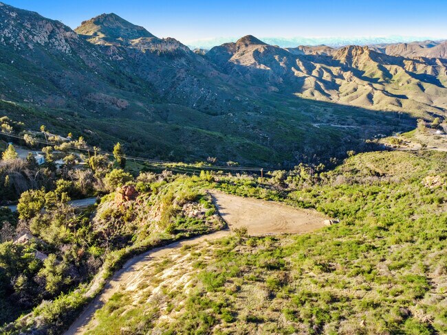
Residentialacreage
LOS ANGELES
LCA11*
California
B and X Area of moderate flood hazard, usually the area between the limits of the 100-year and 500-year floods.
11.89 AC
2024
Santa Monica Mountains
2025
Los Angeles
800335
Los Angeles-Long Beach-Glendale, CA
NEARBY LISTINGS FOR SALE OR LEASE
DEMOGRAPHICS near 0000
1 mile
3 mile
5 mile
2024 Total Population
611
3,624
42,651
2029 Population
632
3,668
42,558
Pop Growth 2024-2029
+ 3.44%
+ 1.21%
(0.22%)
Average Age
45
46
45
2024 Total Households
261
1,394
16,260
HH Growth 2024-2029
+ 3.07%
+ 1.08%
(0.39%)
Median Household Inc
$85,833
$163,855
$157,394
Avg Household Size
2.30
2.50
2.50
2024 Avg HH Vehicles
2.00
2.00
2.00
Median Home Value
$1,045,652
$1,084,928
$1,087,711
Median Year Built
1986
1983
1978
Nearby Places
Map Layers
Map Styles
 Street
 Aerial
Transit
 Traffic
 Biking
Places
Listings with unknown addresses are not visible on the map
- Restaurants
- Banks
- Shops
- Fitness
- Groceries
PUBLIC TRANSPORTATION
AIRPORT
Bob Hope
Drive
Walk
Distance
Bob Hope
61 min
37.2 mi
Los Angeles International
Drive
Walk
Distance
Los Angeles International
71 min
45.3 mi
Freight Ports
The Port of Hueneme
Drive
Walk
Distance
The Port of Hueneme
61 min
35.8 mi
SALE & LEASE HISTORY
LISTING DATE
SALE/LEASE

Mar 15, 2022
For Sale
Nearby Properties
Address
Land Use
TOTAL SIZE
Lot Size
Zoning
Address
Land Use
TOTAL SIZE
Lot Size
Zoning
11,818 SF
8.14 AC
LCRR1*
Address
Land Use
TOTAL SIZE
Lot Size
Zoning
10,293 SF
22.25 AC
LCA11*
Address
Land Use
TOTAL SIZE
Lot Size
Zoning
4,288 SF
5.03 AC
WVCR*
Address
Land Use
TOTAL SIZE
Lot Size
Zoning
4,333 SF
Address
Land Use
TOTAL SIZE
Lot Size
Zoning
Address
Land Use
TOTAL SIZE
Lot Size
Zoning
1,554 SF
34.79 AC
LCRR1*
Address
Land Use
TOTAL SIZE
Lot Size
Zoning
9,505 SF
74.48 AC
LCA11*
Address
Land Use
TOTAL SIZE
Lot Size
Zoning
1,988 SF
10.66 AC
LCRR1*
Address
Land Use
TOTAL SIZE
Lot Size
Zoning
3,200 SF
Address
Land Use
TOTAL SIZE
Lot Size
Zoning
2,129 SF
Address
Land Use
TOTAL SIZE
Lot Size
Zoning
2,140 SF
Address
Land Use
TOTAL SIZE
Lot Size
Zoning
44,112 SF
11.18 AC
LCRR1*
Address
Land Use
TOTAL SIZE
Lot Size
Zoning
111.95 AC
LCR1
Address
Land Use
TOTAL SIZE
Lot Size
Zoning
3,797 SF
Address
Land Use
TOTAL SIZE
Lot Size
Zoning
2,418 SF
Address
Land Use
TOTAL SIZE
Lot Size
Zoning
4,121 SF
5.65 AC
LCA11*
Address
Land Use
TOTAL SIZE
Lot Size
Zoning
3,639 SF
23.45 AC
LCRR1*
Address
Land Use
TOTAL SIZE
Lot Size
Zoning
41.68 AC
LCA11*
Address
Land Use
TOTAL SIZE
Lot Size
Zoning
2,641 SF
Address
Land Use
TOTAL SIZE
Lot Size
Zoning
1,974 SF
Address
Land Use
TOTAL SIZE
Lot Size
Zoning
1.04 AC
LCC3-RR1*
Address
Land Use
TOTAL SIZE
Lot Size
Zoning
Address
Land Use
TOTAL SIZE
Lot Size
Zoning
2,494 SF
Address
Land Use
TOTAL SIZE
Lot Size
Zoning
23.20 AC
LCA11*
Address
Land Use
TOTAL SIZE
Lot Size
Zoning
2,559 SF
Address
Land Use
TOTAL SIZE
Lot Size
Zoning
3,653 SF
10.45 AC
LCA11*
Address
Land Use
TOTAL SIZE
Lot Size
Zoning
2,109 SF
24.54 AC
LCA11*
Address
Land Use
TOTAL SIZE
Lot Size
Zoning
2,864 SF
3.36 AC
LCRR1*
The World's #1 Commercial Real Estate Marketplace
Connect with us
© 2026 CoStar Group
The information above has been obtained from sources believed reliable. While we do not doubt its accuracy we have not verified it and make no guarantee, warranty or representation about it. It is your responsibility to independently confirm its accuracy and completeness. Any projections, opinions, assumptions, or estimates used are for example only and do not represent the current or future performance of the property. The value of this transaction to you depends on tax and other factors which should be evaluated by your tax, financial, and legal advisors. You and your advisors should conduct a careful, independent investigation of the property to determine to your satisfaction the suitability of the property for your needs.