Property Record
0000, Pacific Palisades, CA 00000


NEARBY LISTINGS FOR SALE OR LEASE
Property Detail
0000
Los Angeles-Long Beach-Glendale, CA
OM 4-19-28 FOR DESC SEE ASSESSORS MAPS POR OF LOTS 98,99,106,107 AND 108
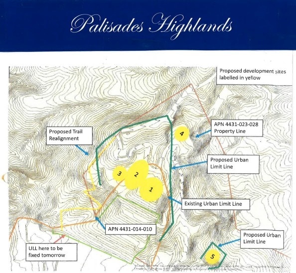
4431-023-028
Los Angeles
Residentialacreage
California
D
98-99
06037C1558F
150.61 AC
2024
Santa Monica Mountains
2025
Los Angeles
980019
DEMOGRAPHICS near 0000
1 Mile
3 Mile
5 Mile
2024 Total Population
3,747
20,577
72,364
2029 Population
3,626
19,995
70,625
Pop Growth 2024-2029
(3.23%)
(2.83%)
(2.40%)
Average Age
46
46
46
2024 Total Households
1,391
8,236
29,812
HH Growth 2024-2029
(3.52%)
(3.01%)
(2.45%)
Median Household Inc
$231,068
$192,403
$167,877
Avg Household Size
2.60
2.40
2.40
2024 Avg HH Vehicles
2.00
2.00
2.00
Median Home Value
$1,133,607
$1,137,754
$1,136,723
Median Year Built
1978
1970
1966
Nearby Places
Map Layers
Map Styles
 Street
 Aerial
- Restaurants
- Banks
- Shops
- Fitness
- Groceries
PUBLIC TRANSPORTATION
AIRPORT
Los Angeles International
DRIVE
WALK
Distance
Los Angeles International
32 min
16.2 mi
Bob Hope
DRIVE
WALK
Distance
Bob Hope
47 min
30.0 mi
Long Beach (Daugherty Field)
DRIVE
WALK
Distance
Long Beach (Daugherty Field)
52 min
36.4 mi
Freight Ports
Port of Los Angeles
DRIVE
WALK
Distance
Port of Los Angeles
59 min
39.6 mi
SALE & LEASE HISTORY
LISTING DATE
SALE/LEASE

Sep 30, 2022
For Sale
Jan 07, 2022
For Sale
Nearby Properties
Address
Land Use
TOTAL SIZE
Lot Size
Zoning
Address
Land Use
TOTAL SIZE
Lot Size
Zoning
193,462 SF
64.72 AC
LAA1
Address
Land Use
TOTAL SIZE
Lot Size
Zoning
64,344 SF
1.04 AC
LAR3
Address
Land Use
TOTAL SIZE
Lot Size
Zoning
25,040 SF
4.19 AC
LAC2
Address
Land Use
TOTAL SIZE
Lot Size
Zoning
16,200 SF
0.41 AC
LAR3
Address
Land Use
TOTAL SIZE
Lot Size
Zoning
24,813 SF
13.23 AC
LARE40
Address
Land Use
TOTAL SIZE
Lot Size
Zoning
0.99 AC
LAC1
Address
Land Use
TOTAL SIZE
Lot Size
Zoning
90,794 SF
7.54 AC
LARE40
Address
Land Use
TOTAL SIZE
Lot Size
Zoning
20,497 SF
24.94 AC
LARE40
Address
Land Use
TOTAL SIZE
Lot Size
Zoning
24,258 SF
0.37 AC
LAR3
Address
Land Use
TOTAL SIZE
Lot Size
Zoning
28,720 SF
0.77 AC
LARE15
Address
Land Use
TOTAL SIZE
Lot Size
Zoning
19,497 SF
1.84 AC
LCC4*
Address
Land Use
TOTAL SIZE
Lot Size
Zoning
27,590 SF
1.09 AC
LAC1
Address
Land Use
TOTAL SIZE
Lot Size
Zoning
31,964 SF
0.43 AC
LAR3
Address
Land Use
TOTAL SIZE
Lot Size
Zoning
10,258 SF
0.44 AC
LCR305
Address
Land Use
TOTAL SIZE
Lot Size
Zoning
10,258 SF
0.44 AC
LCR305
Address
Land Use
TOTAL SIZE
Lot Size
Zoning
13,068 SF
0.20 AC
LAR3
Address
Land Use
TOTAL SIZE
Lot Size
Zoning
5.45 AC
LARE40
Address
Land Use
TOTAL SIZE
Lot Size
Zoning
23,207 SF
0.48 AC
LCR3*
Address
Land Use
TOTAL SIZE
Lot Size
Zoning
0.38 AC
LARE15
Address
Land Use
TOTAL SIZE
Lot Size
Zoning
4,150 SF
0.27 AC
LARE20
Address
Land Use
TOTAL SIZE
Lot Size
Zoning
9,528 SF
0.19 AC
LAR3
Address
Land Use
TOTAL SIZE
Lot Size
Zoning
12,498 SF
0.47 AC
LARD1.5
Address
Land Use
TOTAL SIZE
Lot Size
Zoning
7,898 SF
0.28 AC
LARD3
Address
Land Use
TOTAL SIZE
Lot Size
Zoning
4,373 SF
12.83 AC
LCRR-M1*
Address
Land Use
TOTAL SIZE
Lot Size
Zoning
6.24 AC
LARE40
Address
Land Use
TOTAL SIZE
Lot Size
Zoning
15,966 SF
107.11 AC
LAA1
Address
Land Use
TOTAL SIZE
Lot Size
Zoning
1.22 AC
LARE15
Address
Land Use
TOTAL SIZE
Lot Size
Zoning
11,288 SF
0.48 AC
LCR305
Address
Land Use
TOTAL SIZE
Lot Size
Zoning
0.83 AC
LARE15
Address
Land Use
TOTAL SIZE
Lot Size
Zoning
0.53 AC
LAR1
The World's #1 Commercial Real Estate Marketplace
Connect with us
© 2025 CoStar Group
The information above has been obtained from sources believed reliable. While we do not doubt its accuracy we have not verified it and make no guarantee, warranty or representation about it. It is your responsibility to independently confirm its accuracy and completeness. Any projections, opinions, assumptions, or estimates used are for example only and do not represent the current or future performance of the property. The value of this transaction to you depends on tax and other factors which should be evaluated by your tax, financial, and legal advisors. You and your advisors should conduct a careful, independent investigation of the property to determine to your satisfaction the suitability of the property for your needs.