Property Record
Ramona Ave, Sacramento, CA 95826

This Property Is For Sale
NEARBY LISTINGS FOR SALE OR LEASE
-
-
-
No Photo
-
SE Corner of Jackson Rd and Florin Perkins Rd Rd
Sacramento, CA 95826
$30,000 - $7,730,000
0.04 - 50.47 AC Lot
Land
-
-
-
-
-
-
-
-
-
-
View all Sacramento listings for sale on LoopNet.com
Property Detail
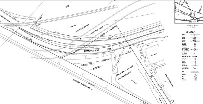
Ramona Ave
015-0033-009
POR OF THE NW 1/4 OF SEC 15, T8N, R5E, MDB&M, DESC AS: BEGAT THE INTERSECTION OF THE ELY R/W LN OF THE S.P.R.R. MAIN
Industrialacreage
Sacramento
X
California
06067C0195H
1.24 AC
2024
South Sacramento
2025
Sacramento
005204
Sacramento--Roseville--Arden-Arcade, CA
DEMOGRAPHICS near Ramona Ave
1 Mile
3 Mile
5 Mile
2024 Total Population
16,466
151,414
404,960
2029 Population
16,753
152,882
408,592
Pop Growth 2024-2029
+ 1.74%
+ 0.97%
+ 0.90%
Average Age
33
38
38
2024 Total Households
6,305
59,744
157,671
HH Growth 2024-2029
+ 2.25%
+ 1.03%
+ 1.02%
Median Household Inc
$58,246
$68,707
$66,996
Avg Household Size
2.10
2.40
2.40
2024 Avg HH Vehicles
2.00
2.00
2.00
Median Home Value
$438,415
$469,558
$450,645
Median Year Built
1971
1965
1966
Nearby Places
Map Layers
Map Styles
 Street
 Aerial
- Restaurants
- Banks
- Shops
- Fitness
- Groceries
PUBLIC TRANSPORTATION
TRANSIT/SUBWAY
University/65Th Street (Gold Line - Sacramento Regional Transit District Light Rail (The RT))
DRIVE
WALK
Distance
University/65Th Street (Gold Line - Sacramento Regional Transit District Light Rail (The RT))
2 min
11 min
0.6 mi
Power Inn (Gold Line - Sacramento Regional Transit District Light Rail (The RT))
DRIVE
WALK
Distance
Power Inn (Gold Line - Sacramento Regional Transit District Light Rail (The RT))
3 min
20 min
1.0 mi
COMMUTER RAIL
Sacramento (Capitol Corridor - Capitol Corridor Joint Powers Authority)
DRIVE
WALK
Distance
Sacramento (Capitol Corridor - Capitol Corridor Joint Powers Authority)
10 min
5.7 mi
AIRPORT
Sacramento International
DRIVE
WALK
Distance
Sacramento International
25 min
17.5 mi
Freight Ports
Port of Stockton
DRIVE
WALK
Distance
Port of Stockton
60 min
51.1 mi
Nearby Properties
Address
Land Use
TOTAL SIZE
Lot Size
Zoning
Address
Land Use
TOTAL SIZE
Lot Size
Zoning
10.28 AC
H
Address
Land Use
TOTAL SIZE
Lot Size
Zoning
7,742 SF
12.66 AC
M-1S-SWR
Address
Land Use
TOTAL SIZE
Lot Size
Zoning
299,943 SF
4.95 AC
H
Address
Land Use
TOTAL SIZE
Lot Size
Zoning
1.33 AC
R-1
Address
Land Use
TOTAL SIZE
Lot Size
Zoning
2,317,288 SF
220.58 AC
M-2-SPD
Address
Land Use
TOTAL SIZE
Lot Size
Zoning
9.29 AC
R-1 OB-R-P
Address
Land Use
TOTAL SIZE
Lot Size
Zoning
1.15 AC
R-1
Address
Land Use
TOTAL SIZE
Lot Size
Zoning
490,607 SF
32.63 AC
RD-30
Address
Land Use
TOTAL SIZE
Lot Size
Zoning
31,163 SF
1.57 AC
C-2-TO-SPD
Address
Land Use
TOTAL SIZE
Lot Size
Zoning
350,049 SF
8.51 AC
MRD-SWR
Address
Land Use
TOTAL SIZE
Lot Size
Zoning
45.93 AC
M-2S
Address
Land Use
TOTAL SIZE
Lot Size
Zoning
281,448 SF
13.42 AC
RMX-TO R-2
Address
Land Use
TOTAL SIZE
Lot Size
Zoning
320,072 SF
2.65 AC
C-2
Address
Land Use
TOTAL SIZE
Lot Size
Zoning
383,000 SF
25.52 AC
M-1
Address
Land Use
TOTAL SIZE
Lot Size
Zoning
179,178 SF
3.35 AC
RO
Address
Land Use
TOTAL SIZE
Lot Size
Zoning
2.59 AC
OB-R
Address
Land Use
TOTAL SIZE
Lot Size
Zoning
122,425 SF
0.59 AC
C-2-SPD
Address
Land Use
TOTAL SIZE
Lot Size
Zoning
119,380 SF
18.92 AC
M-2S
Address
Land Use
TOTAL SIZE
Lot Size
Zoning
1.15 AC
R-1
Address
Land Use
TOTAL SIZE
Lot Size
Zoning
148,642 SF
7.15 AC
RD-30
Address
Land Use
TOTAL SIZE
Lot Size
Zoning
156,462 SF
8.36 AC
R-3
Address
Land Use
TOTAL SIZE
Lot Size
Zoning
280,519 SF
2.50 AC
C-2-SPD
Address
Land Use
TOTAL SIZE
Lot Size
Zoning
40.67 AC
M-2-SPD
Address
Land Use
TOTAL SIZE
Lot Size
Zoning
258,252 SF
1.66 AC
C-2-SPD
Address
Land Use
TOTAL SIZE
Lot Size
Zoning
190,723 SF
9.10 AC
RD-30
Address
Land Use
TOTAL SIZE
Lot Size
Zoning
141,251 SF
4.86 AC
C-2-SPD RM
Address
Land Use
TOTAL SIZE
Lot Size
Zoning
91,185 SF
1.37 AC
C-2-SPD
Address
Land Use
TOTAL SIZE
Lot Size
Zoning
345,600 SF
14.84 AC
M-1S-SWR
Address
Land Use
TOTAL SIZE
Lot Size
Zoning
164,981 SF
3.95 AC
OB-SWR-PUD
Address
Land Use
TOTAL SIZE
Lot Size
Zoning
53,386 SF
7.75 AC
C-2-SPD
The World's #1 Commercial Real Estate Marketplace
Connect with us
© 2026 CoStar Group
The information above has been obtained from sources believed reliable. While we do not doubt its accuracy we have not verified it and make no guarantee, warranty or representation about it. It is your responsibility to independently confirm its accuracy and completeness. Any projections, opinions, assumptions, or estimates used are for example only and do not represent the current or future performance of the property. The value of this transaction to you depends on tax and other factors which should be evaluated by your tax, financial, and legal advisors. You and your advisors should conduct a careful, independent investigation of the property to determine to your satisfaction the suitability of the property for your needs.