Property Record
1909 Unknown, Palm Bay, FL 32905
This Property Is For Sale
NEARBY LISTINGS FOR SALE OR LEASE
Property Detail
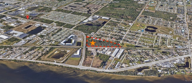
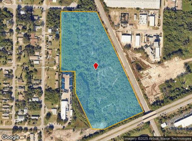
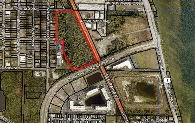
1909 Unknown
Palm Bay-Melbourne-Titusville, FL
P & M Housing Development
28-37-14-00-00003.0-0000.00
THAT PART OF NW 1/4 OF NE 1/4 LYING W OF FEC RR & N OF ROBERT J CONLAN BLVD EXC N 25 FT & W 175 FT, ORB 3955 PG 3936
Industrialacreage
Brevard
A
Florida
12009C0611G
14.59 AC
2024
Brevard County
2025
Orlando
0651231012
DEMOGRAPHICS near 1909 Unknown
1 Mile
3 Mile
5 Mile
2024 Total Population
5,379
56,799
117,422
2029 Population
6,081
62,548
129,077
Pop Growth 2024-2029
+ 13.05%
+ 10.12%
+ 9.93%
Average Age
43
44
45
2024 Total Households
2,341
25,171
50,955
HH Growth 2024-2029
+ 12.82%
+ 9.97%
+ 9.85%
Median Household Inc
$29,662
$46,458
$55,791
Avg Household Size
2.20
2.10
2.20
2024 Avg HH Vehicles
1.00
1.00
2.00
Median Home Value
$125,268
$226,228
$252,369
Median Year Built
1981
1983
1985
Nearby Places
Map Layers
Map Styles
 Street
 Aerial
- Restaurants
- Banks
- Shops
- Fitness
- Groceries
PUBLIC TRANSPORTATION
AIRPORT
Melbourne Orlando International
DRIVE
WALK
Distance
Melbourne Orlando International
15 min
5.9 mi
Freight Ports
Port Canaveral
DRIVE
WALK
Distance
Port Canaveral
54 min
29.6 mi
Nearby Properties
Address
Land Use
TOTAL SIZE
Lot Size
Zoning
Address
Land Use
TOTAL SIZE
Lot Size
Zoning
1,105,462 SF
18.74 AC
CC1
Address
Land Use
TOTAL SIZE
Lot Size
Zoning
1,245,196 SF
110.73 AC
I1
Address
Land Use
TOTAL SIZE
Lot Size
Zoning
1,695,838 SF
106.06 AC
Address
Land Use
TOTAL SIZE
Lot Size
Zoning
408,025 SF
15.72 AC
Address
Land Use
TOTAL SIZE
Lot Size
Zoning
292,165 SF
24.39 AC
RM15
Address
Land Use
TOTAL SIZE
Lot Size
Zoning
332,802 SF
37.02 AC
I1
Address
Land Use
TOTAL SIZE
Lot Size
Zoning
368,326 SF
14.77 AC
C1
Address
Land Use
TOTAL SIZE
Lot Size
Zoning
342,276 SF
12.53 AC
LI
Address
Land Use
TOTAL SIZE
Lot Size
Zoning
326,454 SF
14.20 AC
RM20
Address
Land Use
TOTAL SIZE
Lot Size
Zoning
393,147 SF
38.03 AC
RM20
Address
Land Use
TOTAL SIZE
Lot Size
Zoning
349,772 SF
16.27 AC
R2
Address
Land Use
TOTAL SIZE
Lot Size
Zoning
213,482 SF
1.27 AC
Address
Land Use
TOTAL SIZE
Lot Size
Zoning
24.95 AC
I1
Address
Land Use
TOTAL SIZE
Lot Size
Zoning
295,347 SF
14.61 AC
R2
Address
Land Use
TOTAL SIZE
Lot Size
Zoning
213,704 SF
0.57 AC
CC3
Address
Land Use
TOTAL SIZE
Lot Size
Zoning
201,017 SF
13.77 AC
RM20
Address
Land Use
TOTAL SIZE
Lot Size
Zoning
330,705 SF
25 AC
I1
Address
Land Use
TOTAL SIZE
Lot Size
Zoning
270,428 SF
19.69 AC
R2
Address
Land Use
TOTAL SIZE
Lot Size
Zoning
309,725 SF
14.70 AC
R2 (6)
Address
Land Use
TOTAL SIZE
Lot Size
Zoning
184,447 SF
14.06 AC
R2
Address
Land Use
TOTAL SIZE
Lot Size
Zoning
219,628 SF
29.84 AC
R2(6)
Address
Land Use
TOTAL SIZE
Lot Size
Zoning
560,257 SF
118.47 AC
LI
Address
Land Use
TOTAL SIZE
Lot Size
Zoning
203,448 SF
10.36 AC
C2
Address
Land Use
TOTAL SIZE
Lot Size
Zoning
219,361 SF
3.63 AC
CC3
Address
Land Use
TOTAL SIZE
Lot Size
Zoning
139,968 SF
23.46 AC
CRA
Address
Land Use
TOTAL SIZE
Lot Size
Zoning
225,833 SF
14.45 AC
R2
Address
Land Use
TOTAL SIZE
Lot Size
Zoning
206,724 SF
11.74 AC
R3 (15)
Address
Land Use
TOTAL SIZE
Lot Size
Zoning
205,308 SF
11.04 AC
RM20
Address
Land Use
TOTAL SIZE
Lot Size
Zoning
4,000 SF
12.20 AC
IU
Address
Land Use
TOTAL SIZE
Lot Size
Zoning
340,577 SF
29.82 AC
CP
The World's #1 Commercial Real Estate Marketplace
Connect with us
© 2026 CoStar Group
The information above has been obtained from sources believed reliable. While we do not doubt its accuracy we have not verified it and make no guarantee, warranty or representation about it. It is your responsibility to independently confirm its accuracy and completeness. Any projections, opinions, assumptions, or estimates used are for example only and do not represent the current or future performance of the property. The value of this transaction to you depends on tax and other factors which should be evaluated by your tax, financial, and legal advisors. You and your advisors should conduct a careful, independent investigation of the property to determine to your satisfaction the suitability of the property for your needs.