Property Record
Vac Sierra Highway Vic Ave, Lancaster, CA 93534

NEARBY LISTINGS FOR SALE OR LEASE
Property Detail
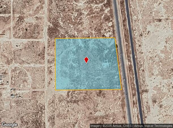
Vac Sierra Highway Vic Ave
Los Angeles-Long Beach-Glendale, CA
29887
3116-014-036
TRACT NO 29887 LOT 3
Desertorbarrenland
Los Angeles
AO
California
06029C4025E
3
2024
9.57 AC
2025
Antelope Valley
900703
Los Angeles
DEMOGRAPHICS near Vac Sierra Highway Vic Ave
1 Mile
3 Mile
5 Mile
2024 Total Population
8,301
59,033
108,880
2029 Population
8,214
57,158
105,653
Pop Growth 2024-2029
(1.05%)
(3.18%)
(2.96%)
Average Age
36
35
36
2024 Total Households
2,441
16,598
33,054
HH Growth 2024-2029
(1.15%)
(3.40%)
(3.14%)
Median Household Inc
$35,614
$49,890
$50,359
Avg Household Size
3.20
3.40
3.20
2024 Avg HH Vehicles
2.00
2.00
2.00
Median Home Value
$61,606
$211,294
$237,314
Median Year Built
1988
1983
1982
Nearby Places
Map Layers
Map Styles
 Street
 Aerial
- Restaurants
- Banks
- Shops
- Fitness
- Groceries
PUBLIC TRANSPORTATION
COMMUTER RAIL
Lancaster (Antelope Valley Line - Southern California Regional Rail Authority (Metrolink))
DRIVE
WALK
Distance
Lancaster (Antelope Valley Line - Southern California Regional Rail Authority (Metrolink))
6 min
4.3 mi
Freight Ports
Port of Long Beach
DRIVE
WALK
Distance
Port of Long Beach
116 min
99.5 mi
SALE & LEASE HISTORY
LISTING DATE
SALE/LEASE

Aug 30, 2017
For Sale
Nearby Properties
Address
Land Use
TOTAL SIZE
Lot Size
Zoning
Address
Land Use
TOTAL SIZE
Lot Size
Zoning
552,178 SF
17.77 AC
LRHI*
Address
Land Use
TOTAL SIZE
Lot Size
Zoning
Address
Land Use
TOTAL SIZE
Lot Size
Zoning
552,178 SF
4.70 AC
LRHI
Address
Land Use
TOTAL SIZE
Lot Size
Zoning
27,070 SF
17.12 AC
LRHI
Address
Land Use
TOTAL SIZE
Lot Size
Zoning
44,015 SF
7.16 AC
LRHI
Address
Land Use
TOTAL SIZE
Lot Size
Zoning
37.45 AC
LRSP
Address
Land Use
TOTAL SIZE
Lot Size
Zoning
Address
Land Use
TOTAL SIZE
Lot Size
Zoning
58.68 AC
LCD22*
Address
Land Use
TOTAL SIZE
Lot Size
Zoning
Address
Land Use
TOTAL SIZE
Lot Size
Zoning
57.24 AC
LCD22*
Address
Land Use
TOTAL SIZE
Lot Size
Zoning
81.54 AC
LCD22*
Address
Land Use
TOTAL SIZE
Lot Size
Zoning
77.36 AC
LCD22*
Address
Land Use
TOTAL SIZE
Lot Size
Zoning
10,512 SF
33.67 AC
LRHI
Address
Land Use
TOTAL SIZE
Lot Size
Zoning
32.84 AC
LCD22*
Address
Land Use
TOTAL SIZE
Lot Size
Zoning
26.32 AC
LCM1
Address
Land Use
TOTAL SIZE
Lot Size
Zoning
17.50 AC
LCD21*
Address
Land Use
TOTAL SIZE
Lot Size
Zoning
11,880 SF
1.04 AC
LRCPD
Address
Land Use
TOTAL SIZE
Lot Size
Zoning
20.24 AC
LRSP
Address
Land Use
TOTAL SIZE
Lot Size
Zoning
51.10 AC
LCD21*
Address
Land Use
TOTAL SIZE
Lot Size
Zoning
35.05 AC
LCD21*
Address
Land Use
TOTAL SIZE
Lot Size
Zoning
30.68 AC
LRHI
Address
Land Use
TOTAL SIZE
Lot Size
Zoning
60 SF
29.74 AC
LCA22*
Address
Land Use
TOTAL SIZE
Lot Size
Zoning
5,491 SF
1.29 AC
LRCPD
Address
Land Use
TOTAL SIZE
Lot Size
Zoning
39.96 AC
LCD22*
Address
Land Use
TOTAL SIZE
Lot Size
Zoning
1,000 SF
9.53 AC
LRHI
Address
Land Use
TOTAL SIZE
Lot Size
Zoning
4,900 SF
2.23 AC
LRHI
Address
Land Use
TOTAL SIZE
Lot Size
Zoning
19,050 SF
9.78 AC
LRHI
Address
Land Use
TOTAL SIZE
Lot Size
Zoning
10.32 AC
LRCPD
Address
Land Use
TOTAL SIZE
Lot Size
Zoning
39.23 AC
LCD2
The World's #1 Commercial Real Estate Marketplace
Connect with us
© 2025 CoStar Group
The information above has been obtained from sources believed reliable. While we do not doubt its accuracy we have not verified it and make no guarantee, warranty or representation about it. It is your responsibility to independently confirm its accuracy and completeness. Any projections, opinions, assumptions, or estimates used are for example only and do not represent the current or future performance of the property. The value of this transaction to you depends on tax and other factors which should be evaluated by your tax, financial, and legal advisors. You and your advisors should conduct a careful, independent investigation of the property to determine to your satisfaction the suitability of the property for your needs.